- Joined
- Sep 22, 2020
- Messages
- 4,691
- Reaction score
- 1,499
LOL, just kidding, of course it exists. But than again, I was only told that it does. I flew a lot of airplane miles. I drove thousands of road miles. I have not seen anything to confirm the below hypothesis. At the same time, I have seen actual places, but I did not see the entire planet from above. Nothing in my experience, or educational background supports this hypothesis. We have GPSs guiding our travels. We have Google Earth capable of showing us even the most distant areas with great detail. Yet, there are a few intricate historical details which prompted me to share some of the observations I made looking through various maps, and documents. Maps, in particular, do raise a few questions, for certain things do raise questions. Primarily why would questionable things of this nature exist in first place?
I will start by mentioning a person named Hubert Howe Bancroft. According to Wikipedia, "Hubert Howe Bancroft (1832 – 1918) was an American historian and ethnologist who wrote, published and collected works concerning the western United States, Texas, California, Alaska, Mexico, Central America and British Columbia."
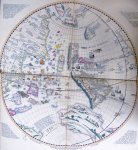
In his History of the Northwest Coast, v1: 1543-1800 (1884), on page 41 I found the following map. Apparently Oronteus Finaeus in 1531 adhered to the original idea that the New Regions (North America) were a part of Asia.
Basically, what we see in the below map, is the continent of the South America hooked up directly to Asia. Sure does not make any sense.

For whatever reason I thought about the other topic on this forum - America in Asia: 1827 State of Nations map. Personally, I do find coincidences highly suspicious in general. At some point, they stop being just coincidences, and become something more than just that. But I was not at that point yet.

Not thinking much thus far, I kept on pushing the topic. Below is the map found on David Rumsey website.

1561 Carta Marina Nvova Tavola

I did the exact same thing, and ended up with the map below.

1620 - Alla carta da navigare - Porcacchi Tomaso

Same operation followed

Planisfério de Rosselli - c. 1508

This map has Hispaniola and Cuba islands on it. From this perspective it is much more interesting to connect both sides. The original map is slightly uneven on the left side, hence the break in connection.

Fun Part
As you can see, the above map has islands like Cuba and Hispaniola on it. From this perspective, the resemblance between the map above, and a few of the older maps below is somewhat weird. What's also weird, we have a Spanish colony Veragua which was located in the Central America situated on one of these older maps.

And it's not where it is supposed to be at. For whatever reason it is placed in that weird non-existent peninsula looking chunk of land.


At the very least, we have a few very interesting maps out there. What they may suggest is up to the individual observer.


* * * * *

KD: Not much here, just a few of my observations. Still trying to figure out how Tartarian Kings end up in the North America, and why Russia used to own Alaska, a chunk of a far away land. Remember that:
I will start by mentioning a person named Hubert Howe Bancroft. According to Wikipedia, "Hubert Howe Bancroft (1832 – 1918) was an American historian and ethnologist who wrote, published and collected works concerning the western United States, Texas, California, Alaska, Mexico, Central America and British Columbia."
Hubert Howe Bancroft

1832 – 1918
Source: The Works of Hubert Howe Bancroft - This is a 39-volume collection of histories of western North America and Central America, written by Hubert Howe Bancroft. It was published in San Francisco in the late 19th century.1832 – 1918
In his History of the Northwest Coast, v1: 1543-1800 (1884), on page 41 I found the following map. Apparently Oronteus Finaeus in 1531 adhered to the original idea that the New Regions (North America) were a part of Asia.
Basically, what we see in the below map, is the continent of the South America hooked up directly to Asia. Sure does not make any sense.
For whatever reason I thought about the other topic on this forum - America in Asia: 1827 State of Nations map. Personally, I do find coincidences highly suspicious in general. At some point, they stop being just coincidences, and become something more than just that. But I was not at that point yet.
1740 Carte des Lieux ou les
Differentes Longueurs du Pendule
Navigation Map

Not much done here, I simply moved North American continent from the left side of the map to the right side. I just figured, why not?Differentes Longueurs du Pendule
Navigation Map

1561 Carta Marina Nvova Tavola

1620 - Alla carta da navigare - Porcacchi Tomaso

Planisfério de Rosselli - c. 1508

Fun Part
And it's not where it is supposed to be at. For whatever reason it is placed in that weird non-existent peninsula looking chunk of land.

At the very least, we have a few very interesting maps out there. What they may suggest is up to the individual observer.


* * * * *
- Fort Elizabeth is the last remaining Russian fort on the Hawaiian islands
- Fort Ross is a former Russian establishment on the west coast of North America in what is now Sonoma County, California.
- There are more than 20 towns in the U.S. bearing the name of Russia’s capital Moscow, three St. Petersburgs and about 10 spots featuring the monikers of Russian regional towns.
- All other things, people and places hidden from us...
Note: This OP was recovered from the Sh.org archive.
Note: Archived Sh.org replies to this OP: Continent of North America does not exist... or could it be a part of Asia?