- Joined
- Sep 14, 2020
- Messages
- 186
- Reaction score
- 345
I propose that the Bering Strait and the Anian Strait are not the same, and old maps that many of us thought show Alaska (myself included) actually show an entirely different chunk of land bridging the two lands of modern day mainland North America and Siberia. It's also possible that Northeast Siberia was either a part of this land or America itself. The latter is I had previously concluded after trying to reconcile how Japan was apparently in the Bering Strait, but I didn't know about the possibility of another territory that reached Japan from America, because maps such as Ortelius labeled it as America. Some label it as The Land of Jesus (or Ainu?). For a while I erroneously thought St. Lawrence Island was Japan and they had somehow moved, but Japan's apparent location in the Bering Strait never sat right with me, and many maps seemingly displayed this.
Many old maps such as the classic Ortelius maps that we've looked at many times have fascinated us when researching Prester John, Quinsay and Arsareth. I've mulled over this for months. I used to think that Japan on these maps was not Japan now, but had to be one of the destroyed islands between Siberia and Alaska, then somehow modern day Japan was named as such after the destruction of the original one. I don't think that anymore, because old maps show some consistency we can refer to today.
Let's look at some of these.
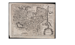
Ortelius Map of Tartary, 1570-1572

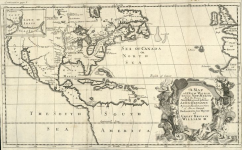
Louis de Hennepin, Map of a Three-Story Country between the New Mexico and the Glacial Sea, 1698

Alleged Nazi map based off the moon plasma map projections (looking to the moon for a reflection of true earth)

I cannot post Urbano Monte's map because it's too massive for my internet to handle uploading, but I encourage you to look at it yourself and compare it to the above Nazi map.
Lastly,

Ages ago, KD speculated that the mythical city of Quinsay was in Russia and not China based off the assumption that the Bering and Anian straits were the same, I thought so too but now I disagree. It's an excellent thread that was key to me realizing some things here.
Another thread that's required reading is Bizarre transformation of the North American Continent: 16th through 19th centuries where we can actually see other maps depicting Anian/Iesso as part of mainland America.
Quinsay cannot possibly have been in modern northeast Siberia because historical maps place it near what seems to be the tail end of the "Great Wall of China".
This is relevant because we're going to be using Japan and the approximate location of Quinsay as important landmarks.
Let's look at a modern map of the path of the great wall and compare it to the Urbano Monte map KD used,


Of course, things move, sink, rise, get destroyed or altered.
We're dealing with a lot of unknowns as usual, but Quinsay is consistently near Japan. That narrows things enough for some rough landmarking.
Some correlations: proximity of a similar lake Quinsay would've sat in to Japan, nearness to the tail end of the Great Wall
A large caveat: Korea is either not seen on Urbano Monte or it's "Corai", a microscopic island.
This approximation is good enough for what we're using it for. Clearly, the lands have changed since the time these maps were made. And I believe we're being lied to, and this land of Iesso (Land of Jesus or Land of Ainu?) may still exist, or may not, but something doesn't add up with the Bering Strait. We'll get to that soon.
Using Japan and the approximate estimation of Quinsay we can roughly estimate some borders. Maybe I'll make myself look like a fool because I don't know how to read map distortions for new or old maps but roll with me for a minute.
The land identified as Amerique or America in some maps such as Ortelius, and Terra de Iesso in others, can't possibly be Alaska as we know it today because of how much lower Alaska would have to be to be near Japan. This necessitates either a third landmass or an extension of America, whether separated by a narrow body of water or not, that is either underwater or hidden today.
Many old maps such as the classic Ortelius maps that we've looked at many times have fascinated us when researching Prester John, Quinsay and Arsareth. I've mulled over this for months. I used to think that Japan on these maps was not Japan now, but had to be one of the destroyed islands between Siberia and Alaska, then somehow modern day Japan was named as such after the destruction of the original one. I don't think that anymore, because old maps show some consistency we can refer to today.
Let's look at some of these.
Ortelius Map of Tartary, 1570-1572
Louis de Hennepin, Map of a Three-Story Country between the New Mexico and the Glacial Sea, 1698
Alleged Nazi map based off the moon plasma map projections (looking to the moon for a reflection of true earth)
I cannot post Urbano Monte's map because it's too massive for my internet to handle uploading, but I encourage you to look at it yourself and compare it to the above Nazi map.
Lastly,
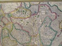
1693 Cantelli da Vignola Map of the Tartar Empire
(note that this one has Tazata island, an island in Scythian myth as well as more very important information I'll let a friend I invited dive into when the time is right.)Ages ago, KD speculated that the mythical city of Quinsay was in Russia and not China based off the assumption that the Bering and Anian straits were the same, I thought so too but now I disagree. It's an excellent thread that was key to me realizing some things here.
Another thread that's required reading is Bizarre transformation of the North American Continent: 16th through 19th centuries where we can actually see other maps depicting Anian/Iesso as part of mainland America.
Quinsay cannot possibly have been in modern northeast Siberia because historical maps place it near what seems to be the tail end of the "Great Wall of China".
This is relevant because we're going to be using Japan and the approximate location of Quinsay as important landmarks.
Let's look at a modern map of the path of the great wall and compare it to the Urbano Monte map KD used,
Of course, things move, sink, rise, get destroyed or altered.
We're dealing with a lot of unknowns as usual, but Quinsay is consistently near Japan. That narrows things enough for some rough landmarking.
Some correlations: proximity of a similar lake Quinsay would've sat in to Japan, nearness to the tail end of the Great Wall
A large caveat: Korea is either not seen on Urbano Monte or it's "Corai", a microscopic island.
This approximation is good enough for what we're using it for. Clearly, the lands have changed since the time these maps were made. And I believe we're being lied to, and this land of Iesso (Land of Jesus or Land of Ainu?) may still exist, or may not, but something doesn't add up with the Bering Strait. We'll get to that soon.
Using Japan and the approximate estimation of Quinsay we can roughly estimate some borders. Maybe I'll make myself look like a fool because I don't know how to read map distortions for new or old maps but roll with me for a minute.
The land identified as Amerique or America in some maps such as Ortelius, and Terra de Iesso in others, can't possibly be Alaska as we know it today because of how much lower Alaska would have to be to be near Japan. This necessitates either a third landmass or an extension of America, whether separated by a narrow body of water or not, that is either underwater or hidden today.
Attachments
Last edited: