- Joined
- Sep 14, 2020
- Messages
- 186
- Reaction score
- 345
I have been trying really hard to find Arsareth, Gog/Magog and Argon/Tenduc for a year now and I brought up the issue of map distortion and continental growth or even the sea border shifting land from what would be an extension of modern day Alaska and northwest USA into what is now most of Siberia in my thread hereYou are right, it is very possible.
I made a super position, what do you think?
Here is a link to the location of the district that appears in the first video, there are no images of the place except the google maps image.
Zhalainuo'er District Google Maps
As you can see, it is a construction zone of new districts in China, I think they imply that they built these buildings but who knows?
As the video narrates, the city looks in semi abandonment and how lucky to have this video because it is the clearest view of this district, how many times I have not heard that they do not build like this and maybe here they want to imply that they do? or is it just a Tartar - Qing - Manchu - Cathay city?
I don't know how well these overlays work because 1628 John Speed shows a more complete map of Siberia featuring Nova Zemla which is absent in the Magnae Tartarie map you seem to have used, and I can't make sense of that.
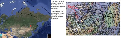
My main theories are the continent changed (and it certainly did because the Kamatchka peninsula and the sea beside it are totally missing until modern day) and/or we have no idea how to factor in distortion of old maps and translate it to the distortion of modern maps, including satellite maps and the moon plasma map/Nazi moon map which gives Siberia a completely different shape. Basically the entire region of Siberia is ambiguous and impossible to geolocate anything from historical maps to until we figure out how to map the distortion and continental morphing. But you're correct that your overlay roughly matches Korea and Japan, which I used as landmarks for my thread to conclude the Anian Strait can't be the Bering. Either there's a huge distortion issue going on with old maps like we have with modern ones, or massive parts of both continents sank and rose and remapped the continental borders to where they're completely unrecognizable and impossible to trace.
If I'm not retarded (and this really doesn't reduce anything beyond my initial calculations that basically the entire continent is a grey zone for potentially tracing settlements like this ghost town and mythical locations) that means Argon/Arsareth/Gog and Magog/"Mongul" on these maps/Sumongul could be anywhere on the north, northeast and east edges of the continent or somewhere in the middle. The continent is colossal and not conveyed well at all in historical or modern maps.
It makes geolocating even this ghost city much much harder because Mongolia is extremely far down south compared to how historical maps make you think. And it COULD be that the entire region of Siberia spontaneously came out of nowhere, or that it expanded east, or receded west, but you have to factor in for Nova Zemla being on older maps like the John Speed one. Those show the entire Siberian area, and the one we're using only shows a part of it. The part we're mapping with Korea and Japan may be more or less almost perfect but the further you get north the more distortion there might be, so our estimations for this ghost town may be off or spot on.
I have no idea until I figure out how to read map distortion. Almost the entire north side of Eurasia is basically the east side
Attachments

Last edited:
