Mappe Monde Celeste Terrestre et Historique 1787

busy.baci

Deleted
Joined
Jan 31, 2022
Messages
346
Reaction score
719
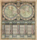
This map is really interesting and has caught my attention for quite some months. I've been busy reading books and researching other topics, but from time to time I revised this map in order to understand more about what it says in the description boxes in caption.

The model it represents is that of the heliocentrism and you could see the classical explanation of the moon phases. But what I'm trying to understand with my poor French is the description the map gives about historical figures and nations. I've seen some dates which are really interesting regarding the formation of European Empires and the leaders which lead them. I can't fully understand what it says because it's in French and I'm not finding any translation of this map in English on the Web.

Please, could someone who knows French from the members read it and try to point out anything irregular for that time period? Something which stands out as out of place or anything of interest in general. I think it's worth a try.

You can find it on Wikimedia Commons also.
 

Attachments

  • 1787_world_map_-_Mappe-Monde_Celeste_Terrestre_et_Historique.jpg
    1787_world_map_-_Mappe-Monde_Celeste_Terrestre_et_Historique.jpg
    9.3 MB · Views: 942
Very interesting map.

I don't speak french, so not sure how much help I can be, but I'm sure you can translate it online easy enough, most of it is easy enough to read.

I did see this in the corner.... its very small, but it seems to say that the orbit of Venus is 365 days, 5 hours and 49 minutes.... which is weird..... isnt that pretty much the Earths' 'solar orbit'?

1657721651597.png
 
I did see this in the corner.... its very small, but it seems to say that the orbit of Venus is 365 days, 5 hours and 49 minutes.... which is weird..... isnt that pretty much the Earths' 'solar orbit'?
That's a good catch. There are some weird dates here in this map even for the old Empires that we already know.

Republiques.jpg
What are those founding dates about the Roman Republic in the year 3545, the Republic of Athens in the year 3984, the Republic of Venice in the year 452 by the inhabitants of the province of Aquila? I don't understand what is the time reference for these dates. It's definitely weird to me.
 
The model it represents is that of the heliocentrism

It seems the map actually implies a concave earth, as explained by Wild Heretic here:


Concave Earth Theory – The Wild Heretic

Most importantly, if you type in “map of the earth 1600” into an image search engine, nearly all the maps of the entire “globe” show a concave sphere. The same applies to “ancient maps of the earth” or “ancient maps“. Even typing “globe” into the keywords – “ancient maps of the globe” brought a total of five convex old world maps with many more concave ones evident.

This shows that nearly all the cartographers in the renaissance (early 1600s) thought the Earth was a concavity, not a convexity. What happened at this time? The “primitive” man idea is ruled out because Concave Earth Theory (CET) is counter-intuitive. Previous to early 1600 AD only Plato believed that we lived inside a concave Earth (Phædo). The Earth (e.g. water) looks like a flat plane to the horizon and so an uneducated man would presume that the Earth was flat. Mathematicians and astronomers in the Middle Ages presumed the Earth was geocentric convex, thanks largely to the publication of Ptolemy’s Algamast… or so we are told. This latter model is also intuitive, as the heavens look to be rotating around the Earth.
 
It seems the map actually implies a concave earth, as explained by Wild Heretic here:
Maybe, from the shape of the parallells it implies the concave model of the earth. But not the same thing for the moon. Why would they include different models of the solar system in this map? They show 3 models of it: The Tycho-Brahay model, the Copernicus model and the Ptolemee model. There is even an oval solar system with 2 suns, one at apogee and the other one at perigee. It's just confusing.
 
I don't know if this has been mentioned by others but on this map as with many older maps there are these faces at the edges of the map blowing wind. I'm not sure if these beings are meant to represent angles and I always assumed they just indicated the general direction of wind but looking at these equally spaced faces all around this map, it looks like it's meant to symbolize an inlet valve of some sort. Are we meant to understand that air pressure worldwide is controlled externally through these? I don't know when the low pressure/high pressure model of wind was first theorized so perhaps this is how they understood things before then. But many suppose the older civilizations have a better understanding of how the world we live in actually works so something to think about.

A second thing which I've noticed and again, I'm not well-versed in maps so perhaps this is know to many already, but Australia is Nouvelle Hollande (which I'm guessing means New Holland) and there above Antarctica is the Magellanique ou Terre Australe but I don't see a Terre Australe, which I don't understand seeing as Australia was apparently "discovered" in 1606. Also, the map shows what looks like New Zealand. It's named N. Zelande. So where is Terre Australe? I would think the name suggests there is a land mass named Australe.

Peace
 
That's a good catch. There are some weird dates here in this map even for the old Empires that we already know.
What are those founding dates about the Roman Republic in the year 3545, the Republic of Athens in the year 3984, the Republic of Venice in the year 452 by the inhabitants of the province of Aquila? I don't understand what is the time reference for these dates. It's definitely weird to me.
Really interesting, considering the first date is the jew republic, founded by moises in 2543, and that lasted 1580 years, until the temple got destroyed in 79 of IC ou JC (Jesus Christ i guess ?) Weird date and all, nothing is making sense. The roman republic was created before athen, which is not the case in our history book ?

If any of you have something that would need explanation, i can provide help, since i speak french ! The map is in old french, but i understand most things on it !

Also @Seeker you're right with venus, but in the middle right on the border, it states that the sun is doing a revolution in 365 days and a couple of hours, which is also strange !

Anyway folks, this map is really special, and i'm trying to find indications on the strange dates that don't add up !
 
Maybe, from the shape of the parallells it implies the concave model of the earth. But not the same thing for the moon. Why would they include different models of the solar system in this map? They show 3 models of it: The Tycho-Brahay model, the Copernicus model and the Ptolemee model. There is even an oval solar system with 2 suns, one at apogee and the other one at perigee. It's just confusing.

I noticed something very interesting about those 3 models.

All of them have a firmament. Always appearing just before the stars. (See red arrows)

Can anyone read/translate what is written by the yellow arrows? (@Jsallard ?)

1657823923008.png

Also, interesting symbol for Mercury

1657824397567.png
 
Last edited:
If any of you have something that would need explanation, i can provide help, since i speak french ! The map is in old french, but i understand most things on it !
This would be a great help indeed. I noticed that dates refer in accordance with the creation of the world. In the first round green bouquet at the left it says that the world is 5772 years old at the moment this map was made. The date for Mohammad is placed correctly at the year 570 AD according even to our calendar, sot the 4k year dates used in these map must be correct also. I guess.

The map describes Nimrod as a religious leader of the Payenees. From what I know that sect was founded in France. Anonyme. Du rapport de la Magie avec la Théologie payenne. Extrait de « Histoire de l’académie royale des inscriptions et belles lettres », (Paris), tome septième, 1733, pp. 23-32.
Aparently in the past, black magic, alchemy, demon worshiping was considered a valid religion on par with Christianity or Islam. Super weird.

What is interesting is what it describes about Jesus, he's the third person from left in yellow toga in one of those green round bouqets.

Iesus.jpg
Le monde.jpg

1."COM. SARE. 30. et MOR. a33 IESUS CHR.NAI en 4053 A"
2. "Le MONDE a començe al'Equinoxe du Printems: ily a 5772 ou 4053 ans avant I.Christ par Adami"

  1. Is it saying that Jesus commenced at 30 years old as a prophet and died at 33 years of age in the year 4053 after the creation of the world?
  2. In the second cut image about the world what is it saying exactly about Jesus and the creation of the world from Adam? I think those dates are crucial for reading correctly the rest of the events described in this map.
 
Last edited by a moderator:
I noticed something very interesting about those 3 models.

All of them have a firmament. Always appearing just before the stars. (See red arrows)

Can anyone read/translate what is written by the yellow arrows? (@Jsallard ?)


Also, interesting symbol for Mercury

The first yellow arrow in pointing toward ''Premier Mobile'' which is ''First Mobile'' but a mobile is the thing suspended above the new born cradle that turn with shapes or planets.
The second yellow arrow is pointing on ''1 Cristalin'' with one ''L'', but in french it takes 2 (Cristallin) and it translate to ''1 Crystalline''. There's also a ''2 cristalin'' and under that the stard with the firmament ! Kinda strange honestly.

@BusyBaci :
The first point is in latin, not in french ! I tried to translate it but was not able. But the year 4053 should be the year he was born, not died (Because of the point 2)

The second one is interesting : 2. "Le MONDE a començe al'Equinoxe du Printems: ily a 5772 ou 4053 ans avant I.Christ par Adami"
and can be translated to : ''The world started at the spring equinox : 5772 years ago or 4053 years before Jesus Christ by Adami'' I'm not sure the ''By Adami'' is what but with the capital letter it is probably a person, maybe the calendar inventor?
Your guess is good for the dates. The map was made in 1786*

*
1657885324756.png


So if we do (5772-4053)= 1719 , the year of the creation of the map should be 1719 not 1786. There's a 67 years gap that need to be placed somewhere. Is Jesus Christ born on year 67 of our calendar ?

Also, the 5 circles under jesus describe the 4 sects of christianity (That are heresy as described in the text) : The arianism, the grec schism, the luteranism and Calvinism. The 4 sects are known today, but the first one more than any other (I'm looking at you Hitler) :
1657886079404.png
Apparently the Ariens were created in 316 (Before or After Christ is unknown, probably after since it christianity, so year 4053 + 316 = 4369 ) but it's the oldest (By far) of the 4 sects of christianity. The were lead by Arius, priest of Alexandria. The sect have be tolerated in Holand, Hungary and Turkey.

There's so much stuff on this map, it's amazing !

Also sorry for the long wall of text
 
The first point is in latin, not in french ! I tried to translate it but was not able. But the year 4053 should be the year he was born, not died (Because of the point 2)

The second one is interesting : 2. "Le MONDE a començe al'Equinoxe du Printems: ily a 5772 ou 4053 ans avant I.Christ par Adami"
and can be translated to : ''The world started at the spring equinox : 5772 years ago or 4053 years before Jesus Christ by Adami'' I'm not sure the ''By Adami'' is what but with the capital letter it is probably a person, maybe the calendar inventor?
Your guess is good for the dates. The map was made in 1786*
No need to apologize. Thank you very much for confirming it, your input is priceless. The production history of this map is long and it was made in a long time span with different updates to it by different cartographers. I think the last update it received was in the year 1786, so every other event's date described in it must have been calculated in respective to the year 1786.

Here is a short history of the map: 1787 Jaugeon / Desnos Wall Map of the World in Hemispheres
quotes:

Screenshot 2022-07-15 at 14-45-43 1787 Jaugeon _ Desnos Wall Map of the World in Hemispheres.png
 
I did my best to translate some of the text in captions about the Muscovites by using google translate. I'm sure I did made plenty of errors writing that text in correct French because of the flooding Latin abbreviations it uses, which I can't fully comprehend. Here it goes:

La Moscovie.jpg
"LA MOSKOVIE
Qui veut dire en hebreu ou les homes vsent de l'arcet sont cruels, et qui a po fondat Moloch, fils de Iaphet, qui veutdire Environnant. Estune Monarchie heredit, qui contient 3 Roiau et 22 provinces: Arrousee de 4 fleuv dont un porte 700 lieiies batteau ans sortir de cet Estat qui estriche en Cire, Miel Bois et Fourrur Tous les peupl y sont Esclay de leur Czar ou Emperor titre que Bazile Iean a cpris en 1537. Ony conmence l'anee aou mois de 7 l'ordere de Chevalerie est de St. Georg la Relion estla Grec Sep 1036 a comence en 887 Ruric etse gouverne par Pierre Alexeovitz a present."


Translation:

MOSKOVIA Which means in Hebrew where men with bows are cruel, and who founded Moloch, son of Iaphet, which means Surrounding. Is a hereditary Monarchy, which contains 3 Kings and 22 provinces: Watered by 4 rivers, one of which carries 700 leagues of ships to leave this State which is rich in Wax, Honey, Wood and Fur All the people there are Esclay of their Czar or Emperor title that Bazile Iean took over in 1537. Ony begins in the year August or month of 7 the order of Knighthood is of St. Georg the Relion is the Greek Sep 1036 began in 887 Ruric and is ruled by Peter Alexeovitz at present.

A very interesting story to tell. Especially about the known god Moloch being represented here as the son of Iaphet. I had no idea Iaphet was into black magic and paganism. Really interesting.

Edit: Is this map implying about a Moloch like this one as the son of Iaphet:

moloch.jpg

So according to the map, the grand son of Noah is Moloch and he has something to do with Muscovites and he's into child sacrifice offerings.
This guy reminds me of the Minotaur who was killed by the mighty hero of Greek legends, Theseus. The bull, one of the beloved symbols of Wall Street. ha
We're in a bear market by the way. lol
 
Last edited by a moderator:
This is a very interesting map. Just how much of the information is valuable, how much invented ?

Never heard of some Republics like Luques or Genes (Genova?) and never heard of Dominique Fulgose, so googled the name and found this Almanac from 1760 containing some of the text from the map. So it seems that this was official HIStory in the 1700s, even with changes within that century.

In 1760 Louis XV was King of France from 1715 until 1774, then came Louis XVI until 1792, when France became a Republic & Empire under Napoleon I. I think it’s strange that from 1610 to 1792 4 consecutive Kings were namend merely Louis. (XIII – XVI)

Link Almanach

dominique.JPG

There are differences between the text on the map and the one in the book, at least for the following Republiques:

Republique of Athenes ;)

athene-republic.JPG

different dates of creation, map: 3984 Book: 4914

On the map is clearly noted Medon, premier Archonte, premier = first archon and in the book MEDON is the dernier Archonte dernier = last one.


Republique of Switzerland, different dates of creation, map: 1315 Book: 1535

suisse-repu.JPG

suisse-repu-book.JPG

The Republique of RAGUSE is not mentioned in the book.

raguse-only-map.JPG

There are more differences for sure, it will take some time to go through all of it

Edit:

I would like to add a better translation of the part from Muscovy, this is really very interesting, not to be found in the book !

Muscovy
Which means in Hebrew where men use the bow and are cruel and which has for founder Moloch, son of Iaphet, which means Surrounding. Is a hereditary monarchy, which contains 3 Kingdoms and 22 provinces: Watered by 4 rivers, one of which carries 700 boat leagues without leaving this state, which is rich in Wax, Honey, Wood and Furs. All the peoples there are slaves of their Czar or Emperor, a title that Bazile Iean took in 1537. The year begins there in the month of 7ber. The order of chivalry is of St Georg, the Religion is Greek since 1036 started in 887 by Ruric and the first governor Pierre Alexeowitz at present.

Bazile means Basileo, a macedonian titel Alexander 3,the Great used to have.
 

Attachments

  • greco-empire.JPG
    greco-empire.JPG
    85.6 KB · Views: 127
Last edited:
Hi, native french speaker here.

First off, I used a high resolution scan of the map to read it more comfortably.

I was looking around and... there is a "La Grande Tartarie" (Great Tartary) section. So I thought to myself that you guys would probably be interested!

la-grande-tartarie.png

LA GRANDE TARTARIE

Estoit autrefois un Empire hereditaire le plus grand et le moins connu de l'Asie composé de 5, grands Etats arrousé de six Fleuves dont un appellé Tortar, conserve le nom des peuples que les Hebreux nommèrent Tortares Reste, où Laissé apres qu'une partie de leurs tribus fut relegué aude-là de la Medie: Les mesme qu'ils appellerent Magogiens et les Romains Massag[eriens ou] Getes, Caché où Liquefié comme qui diroit Inconnus et Espars, jusqu'en 1200 que Zingis Cham fonda leur Empire. Ils se divisent par Hordes ou Assemblée, Etoient Circoncis avant 1247, qu'ils reçeurent le Mahometisme. Tenté en plusieurs endroits, et ne se gouverne a present que par plusieurs Princes assés malheureux.

Note: I expended the abbreviations and in places were the original text was erased, I added my best guess in between brackets.

GREAT TARTARY

Was in olden days an hereditary Empire the greatest and the least known of Asia composed of 5, great States watered by six Rivers of which one called Tortar, keeps the name of the people that the Hebews named Tortares Rest [trad.: remaining part], or Left alone after a part of their tribes was relegated beyond Medie [trad.: Media?]: the same that they called Magogians and the Romans Massagerians or Getes, Hidden or Liquified as one would say Unknown and Dispersed, until 1200 when Zingis Cham [trad.: Gengis Kan?] founded their Empire. They are divided in Hordes or Assemblies, Being Circoncised before 1247, when they received Mohammedism [trad.: Islam]. Tented [trad.: dwelling in tents?] in several places, and at present being governed only by a few rather unhappy Princes.

Note: I wrote words added for comprehension in italic (like in the KJV) and translator notes in between brackets.

Wow, that was intense! Great Tartary being an actual empire founded by Gengis Kan, populated by some of the lost tribes of Israel, that converted to Islam like stated in the infamous CIA document... what do you think?

If you want me to look at another section of the map, please tell me in this thread.
 
Last edited:
Is there some reason for the map authors to explain placenames by how the Hebrews call them? Did the old French mindset perceive it as some primal knowledge? Because the explanations don't seem right.
Muscovy
Which means in Hebrew where men use the bow and are cruel and which has for founder Moloch, son of Iaphet, which means Surrounding.
This sounds like the classic European perception of Tatars or Scythians.
I fail to understand how any form of Muscovy/Moscow could mean that in Hebrew.

For reference,
Bow = Keshet קשת
Cruel = Akhzar אכזר
There are synonyms for 'cruel' and 'men' but they're still unrelated here.

As for Iapeth, does he also mean to say here that "Surrounding" is from Hebrew?
Iapeth or Yefet is derived from Beauty, and also means to open/expand.
GREAT TARTARY

Was in olden days an hereditary Empire the greatest and the least known of Asia composed of 5, great States watered by six Rivers of which one called Tortar, keeps the name of the people that the Hebews named Tortares Rest [trad.: remaining part], or Left alone after a part of their tribes was relegated beyond Medie [trad.: Media?]: the same that they called Magogians and the Romans Massagerians or Getes

Unfortunately there is no name such as Tortares/Tartars and the likes, used originally by Hebrews/Jews to name themselves or any people. In Hebrew literature, the people of Tartary can be called Kadars, Gog/Magog, Ishmaelites.
'Tartar' was adopted to Hebrew from Western literature.

As for Tartars being lost tribes of Israel, it is purely based on one, disputed point of view within Judaism. It can be considered, but not used as proof.

The Talmud tells a story about the directions in which the 10 Tribes were exiled. The Talmud is known to have used many placenames that nobody understands, and their meaning is discussed over for centuries.
So one of the directions is past the "Sambation River". Sambation is not in Hebrew, obviously. (It's not the only direction, though)
The Talmudic legend says, that the tribes are "trapped" beyond the river, because it is always raging, and only rests on Saturday (when Jews aren't allowed to cross). Basically an allegory to why the tribes are never coming back.
It is said by medeival Jewish scholars that the name Sambation comes from Sabbath, Saturday, and therefore it isn't a real river.

But in early modern times, scholars became obsessed with the river, and tried to identify it, anywhere from Africa to Turkey, Syria, and Afghanistan. Some even went on expeditions to locate it.
One of the identifications says that since the Arabs called the Don river
"Al Sabat" and that Kyiv was named "Sambats" by Constantine VII, then that must be the river. This one POV developed into identifying Tartars with the lost tribes, and it's really a longshot. It just coincides with the mystery of the Tartar origin, and the lost tribes legends, that made some scholars assume the connection.

I'm personally not in support of the ancient Jews being exiled from West Asia.

Does this map have other instances where explanations are referenced to "The Hebrews"?
 
Does this map have other instances where explanations are referenced to "The Hebrews"?
Yes it does. I'll be looking around and translate one per day until there is no more.

Next stop, the most beautiful country in the world: France!

1660672306800.png
LA FRANCE

Appellée GAULE de l'hebreux Galaath, Pluie acause de ses innondations frequentes, où de Gala Laict de la blancheur de ses peuples est un Roiaume hereditaire composé de plus de 40 Provinces au moins de 4000 villes, a 11 Parlemens, 18 Archeveschés, 108 Eveschés, 13 Chefs d'Ordres où de Congregations, plus de 40000 Cures, et 17 Universités ; arrousé de 4 principales Rivieres ; a les Alpes, les Pyrennées, le Rhin, et la Mer pour bornes. Riche en Bled, Vin, Sel, et Toille. Son Ordre principal de Chevalerie est du Saint Esprit. Acommencé en 418 par Pharamond. professe la religion Romaine et se gouverné par Louis 15 le bien aimé[r] de Ses Peuples

FRANCE

Called GAULE from the hebrew Galaath, Rain because of its frequent floods, or from Gala Laict because of the whiteness of its people is a hereditary Kingdom composed of more than 40 Provinces at least 4000 cities, has 11 Parliaments, 18 Archbishoprics, 108 Bishoprics, 13 Chefs of Orders or of Congregations, more than 40000 Presbyteries, and 17 Universities ; watered by 4 principal Rivers ; has the Alpes, the Pyrenees, the Rhine, and the Sea for limits. Riche in Wheat, Wine, Salt, and Clothe. Its principal Knight Order is of the Holy Spirit. Began in 418 with Pharamond. professes the Roman religion and was governed* by Louis the 15 the beloved of His People.

* I think this is a mistake, it should be "is governed", but the last accent on "gouverné" makes it past tense. Maybe an edit made after the death of Louis the 15?

It's very interesting to see that the Gauls were called this way because of the floods. I saw a reference to this yesterday: Sixteenth century maps from Tuscany

For reference,
Bow = Keshet קשת
Cruel = Akhzar אכזר
There are synonyms for 'cruel' and 'men' but they're still unrelated here.
I don't have the skills to do it myself. Could you check the words bow and cruel in aramaic and in yiddish? Thank you!

Edit: Thanks to @intothevoid for providing the correct translation for "Cures".
 
Last edited:
I fail to understand how any form of Muscovy/Moscow could mean that in Hebrew.


Does this map have other instances where explanations are referenced to "The Hebrews"?

I have no idea how they came to any of the informations about the nations displayed on the map. Those are also not listed in the Almanach of 1760. Maybe that was "secret" info for the King Louis .. but it was rather a "Trojan Horse" !
Meaning of Moscow could be "dissolving or melting star", as taken hebrew letter roots from "Ancient hebrew lexicon of the Bible":
MaSKaB ? MS KB dissolving star?
ms.JPG
kb.JPG

yes, I think there are a few references on the map with "ebreux" ou hebreux, I can collect them, if you want.

Same for the date of creation of the world, how could they know or calculate it?

you might have guessed, there are also differences for those years on map/book

Map: Start Spring equinox 5772 years ago or 4053 before Christ
would be 5772-4053 = 1719 … now the map was allegedly created over a long period of time to be dedicated in 1783 to the King.

monde-debut.JPG

Almanach: Start Spring equinox 5741 years ago or 4051 before Christ
5741-4051 = 1690, but the Almanach is from 1760 ? 70 years of difference !

commencement-1.JPG
Maybe 1690 was the date, when the text was first written? But then why didn’t they bother to correct the number of creation years for the 1760er Almanach, wherein they tell even the exact times of lunar & solar eclipses from that year ? That is strange!

And then there is still 2 years of difference for the birth of Christ.

Now there is the Metonic cycle of the moon, every 19 years the moon is at the exact same place in the firmament. Even the dates of new/full moons are the same for long time within a cycle of 19 years … example full moon 5.12.2025, 2006, 1987, 1968, … check here

The sun returns to the same place in the zodiac at spring equinox every 33 years or 12053 days, accurate to within 20 seconds … Iesus, the son/sun born on winter solstice, dies at 33. Religions are star gazer myths. Encoded sacred/secret knowledge.


Sun & moon are SYNchron again on the same zodiac place after 19 x 33 cycles = 627 years. I guess to start, both sun & moon were at the Equatorial line, Spring Equinox, new moon .. or full moon at equinox

The Metonic cycles should at least be the same for the years they tell people. Let me grab my calculator !

This is how the Metonic cycle is calculated:

The golden number of any Julian or Gregorian calendar year can be calculated by dividing the year by 19, taking the remainder, and adding 1. (In mathematics this can be expressed as (year number modulo 19) + 1.)

For example, 2022 divided by 19 gives 106, remainder 8. Adding 1 to the remainder gives a golden number of 9.


MAP: 5772 = 1719

Year 5722 = Metonic cycle 16, Year 1719 = Metonic cycle 10

BOOK: 5741 = 1690

Year 5741 = Metonic cycle 4, Year 1690 = Metonic cycle 19
and Year 1760 = M13, as indicated in the Almanach 1760

This is just about confusing us with everything, as well with the former nations, the number of years, … do “THEY” not want us to know where we are in the cycle ? … because when there is a start, there is also an end, unless it’s looped ? Or … ? I do not buy the Big Bang Theory !

The end of the realm, like the sun goes dark? Son/sun dies, after 33 cycles ?? it would mean the end of all organic life.
33 x 19 = 627 ? or 33 x 627 = 20 691 solar years ? or lunations ? Or ... ? whatever, we are no longer able to read that “clock”.
 
Last edited:
Tips
Tips
Please respect our Posting Rules.
Back
Top