Native American Nations and Septentrionalis

Starfire

Moderator
Staff member
Active Member
Joined
Jun 15, 2022
Messages
216
Reaction score
694
Location
Cleveland, Ohio
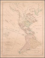
By now I think we've all seen Septentrionalis on a map, either on the North American continent as America Septentrionales or on the Arctic Sea/North Sea as Mare Septentrionales. When you look it up they tell you it means north, but I do think there is more to it than that (as usual).

Quiahuitl posted this in the Novaya Zemlya thread:
"This is all very interesting. There's the Mare Septentrionalis in 1576 and most of North America is marked Septentrionalis around this time and onwards for a century or more at least into the 1600s and on into the 1700s if memory serves.

Septentrionalis means seven tribunals in Latin so there's a theory this was the name of a legal jurisdiction or empire. Or maybe a trading empire. Or even just a banking and justice system within which fair trade was possible.

I checked the Latin and trionalis means every three years - triennial. 'Tribunal' is actually a Latin word that we still use unchanged in modern English. I wonder if this is the opposite of our system of Babylonian debt slavery - a trading system in which every debt must be cleared within three years so the accumulation of 90% of everything into a few hands wasn't possible."


I responded with:
"Perhaps seven areas/local governments overseen by a central government with elections every three years?
Also regarding debt forgiveness, you probably already know about Jubilee Years including debt forgiveness. It's the 50th year after 7 years x 7 years=49 years."


and

"When a building was updated...very often the sets of three arched windows and doors were removed and made square and sets of two. One poster thought this was to change the harmony of the area. It may have been. But I think it also was a domineering power play against the Old World Trionalis."

When I sidetracked into the Cherokee Nation recently I discovered their seal contains a seven-pointed star, dated September 6, 1839. This was their forced new home in Oklahoma Indian Territory, at their new capital Tahlequah.

Cherokee_Capitol_1869_(13).jpg

The seven-pointed star was their traditional symbol. It was said to represent the seven clans of the tribes or the seven tribes of the Nation. Their Peace Flag was said to be seven red seven-pointed stars arranged as the Big Dipper on a white background. The War Flag was reversed colors. The Big Dipper is part of the Ursa Major/Great Bear constellation and always appears in the northern sky in the northern hemisphere. Could septentrionalis have come to mean north in navigation due to the seven stars of the Big Dipper always appearing in the north? And then the original meaning for it as the name of an entire culture was able to be buried by TPTB.

Even today the modern Cherokee Nation flag contains seven white seven-pointed stars plus an extra black seven-pointed star for the people who died on the Trail of Tears.

The Cherokee Nation and a confederation of native tribes/nations could have been the same seven in septentrionalis. Perhaps there were three nations or confederacies that all had the number seven as a symbol. Together they could be covering all of what we call North America.

I looked at the Iriquois Confederacy. They were 5, then 6 tribes, so no luck there. But their hero Hiawatha had seven daughters! Kind of like how the stars Pleiades are called the Seven Sisters, and are the seven daughter of Atlas.

Having grown up in the Pacific Northwest, I am pretty familiar with the tribal system out there. They didn't get butchered as much by the colonizers, but they did still die of illnesses. They weren't known to be a great confederacy in the recent past. But they all had similar culture and lifestyle. They used cedar trees for almost everything - the trunks for totem poles, canoes and longhouses, bark as clothing and blankets, wood for fires, sap as resins and glues, branches as waterproof thatch, berries and cones for medicine and maybe food. They lived on a lot of seafood and berries. They rotated holding great Potlaches where they would feast and give presents. They also held council and made decisions at the Potlatches. The Seven Sisters of the Pleiades were very important to them and was prominent in their mythology. But I am not aware of a unifying symbol.

The great Sioux Nation certainly has both seven and three represented. From blog.nativehope.org:
"The appropriate name for the Sioux is the People of the Seven Council Fires (Očhethi Šakowiŋ Oyáte). They speak one of the three dialects of the same language, Siouan. Within the Očhethi Šakowiŋ are seven bands: Waȟpékhute, Waȟpéthuŋwaŋ, Sisítȟuŋwaŋ, Bdewékhaŋthuŋwaŋ, Iháŋktȟuŋwaŋ, Iháŋkthuŋwaŋna, and Tithuŋwaŋ. There are now various groups who descend from the original seven and maintain autonomy over the governing of their oyáte (tribe).

The terms "Lakota," "Nakota," and "Dakota" are often used interchangeably with "Sioux," and they are the three largest subsets of the Great Sioux Nation."


The Great Sioux Nation could maybe be Septentrionalis by itself, with those number associations. It did stretch across the middle of what is now Canada and the United States.

Please add to these thoughts or let me know if I might have a strong theory here.
 
Last edited:
I propose that the ancestors of the Native Americans co-existed with the giants that were living in North America. This applies to South American natives and giants too, but I am not as familiar with their mud flood status and history. The Spanish and Portuguese got there early enough they were able to pretend that they built the buildings themselves. Early explorers speak of giants in Patagonia, but they must have died of disease (or something). The Incas and Aztecs have giants in their histories. Central and South America have many stories of giants living peacefully with humans or co-existing peacefully in nearby settlements.

I believe that the mudflood buildings were built by the giants and natives to live together, since they have taller and shorter stories together in the same buildings. The ancestors of the Native Americans lived in the shorter UPPER stories of the buildings. The giants lived in the taller LOWER stories. Their relationship was most likely the giants as masters and the native humans as slaves/servants. (Or they could have been equals. Or the humans may have been masters over the giants, using them as dumb labor and keeping them fed and housed in exchange. Who knows, so many things are lies...)

This giant/taller bottom story/stories and much shorter human upper stories is more noticible in a lot of European Old World buildings that were never mud flooded or were dug out of the mud. Here in the United States a lot of bottom stories were left buried and just modified/remodeled to explain it. But in the buildings that were dug out you can see what I'm saying.

Untitled-4.jpg
th-2677003024.jpg

This one didn't get dug out. You can see there were two tall stories before the short stories started.

th-152264188.jpg

The co-existing giants and humans would have all been part of the same existing social structure of the time. Trade, socializing, festivals - all would have included both humans and giants. They would have lived within the same political structure as well. It was most likely three larger groups which each had seven smaller groups within it. The Europeans called it Septentrionalis on their maps before it was destroyed. We don't know what they called themselves. This was an intact Hyperborean culture with huge antiquitech buildings and an active airship system, with giants and humans co-existing and living in the same buildings with each other (with the humans as slaves). Just like European and Asian cultures used to have (with the humans as slaves).

However, at the same time there were tribes of natives who DIDN'T live with the giants. They lived in their tipis or huts and hunted, fished, grew, gathered. And they were free. They called their land local words that meant "Land of the Feathered Serpent". They had their confederations and nations. They probably traded with the giants. Some of their young adults probably wanted to go live in the cities and work for the giants as indentured servants.

I found this on Ancient-origins.net:
Chief Rolling Thunder of the Comanches, a tribe from the Great Plains, gave the following account of an ancient race of white giants in 1857:
“Innumerable moons ago, a race of white men, 10 feet high, and far more rich and powerful than any white people now living, here inhabited a large range of country, extending from the rising to the setting sun. Their fortifications crowned the summits of the mountains, protecting their populous cities situated in the intervening valleys."
"They excelled every other nation which was flourished, either before or since, in all manner of cunning handicraft—were brave and warlike—ruling over the land they had wrested from its ancient possessors with a high and haughty hand. Compared with them the palefaces of the present day were pygmies, in both art and arms. …”
The chief explained that when this race forgot justice and mercy and became too proud, the Great Spirit wiped it out and all that was left of their society were the mounds still visible on the tablelands. This account was documented by Dr. Donald “Panther” Yates , a researcher and author of books on Native American history, on his blog.

Yates also writes of the Starnake people of Navajo legend, describing them as: “A regal race of white giants endowed with mining technology who dominated the West, enslaved lesser tribes, and had strongholds all through the Americas. They were either extinguished or ‘went back to the heavens.'”


Then the worldwide mud flood happened around 1650 Scalinger time, reputedly due to a comet, but more likely caused by the Europeans against the giant cultures to finally finish them off. It may have been the earth's crust slipping or the pole shifting. The soil could have easily been liquified with sound or vibrations to sink the buildings 10-15 feet. This buried the taller first story where the giants lived. If the liquification was done at night when all of the giants were sleeping, it would kill the majority of the giants. Meanwhile the humans (slaves? workers? friends? it's hard to know...) would still be alive because they lived and slept in the shorter upper stories.

The human survivors safe upstairs are the ancestors of today's Native Americans. They would have been spiritual people then, as they are now. Probably even more so if they were living the Hyperborean lifestyle of clean energy and spirit, possibly fed and nurtured by sound and vibration alone. Such a pure life they didn't need bathrooms in the buildings...

I believe that some of these spiritual people would have run for the hills when the catastrophe happened!!! They would have seen their god striking down the giants whilst sparing the human lives as a punishment. The buildings were likely seen as tainted and having bad juju by some of the natives. Like the Chief says in the quote above. The natives that left were probably slaves that had been stolen or bought from the natives and would have been welcomed back by their tribes.

Others may have continued to live in the partially buried buildings until forced out by the White Man. These humans were probably multigenerational "born to the manor house" and no longer part of any native tribes. They were probably the overseers and foremen and trusted close servants and bastard children of the giants. They probably kept some humans enslaved and had the whole southern plantation lifestyle in place before the colonists started pouring in.

They would have tried to maintain social structures that had existed for humans before the mud flood. Interpersonal relationships and clan identities would have continued, and some local trade - but trade and communications with national communities would have stopped. The airships that were in the air at the time would have survived for a while, but the on ground repair shops and support systems were gone. The cyclotrons that recharged the electric trollies and cars were buried, along with the trollies and cars. All of a sudden they didn't have power, food or support systems.

The few giants who survived had even more problems than the humans! First of all, their homes were uninhabitable and all their belongings were ruined. They were too large to live in the upper stories where the humans were living. They could stay outside in warm weather, but had to find large caves to live in during cold weather and then stayed there. All their giant sized clothing and tools were gone, so eventually they wore animal skins. Their crops were destroyed, so no food and no seed crops for next year either. Any penned animals would have been unable to escape to higher ground and would have perished. So if they ate produce and meat, they were starving. The antiquitech in the buildings was ruined by the mud, so if they subsisted off energy, they were starving. And they needed a lot more food to survive because of their size.

The MAIN problem the giants had was that they were no longer the boss. All of a sudden there were WAY less giants than humans. They didn't have their human servants slaughtering a lamb for them, roasting it on a brazier, sprinkling it with herbs and spices, and whispering prayers and blessings over it before choosing the choicest portions for them. (Oh wait, I might be getting confused with a priest...)

Eventually the giants regressed into cave dwelling cannibals. The giants didn't have the sustenance they were used to, so eventually they turned to eating natives. A lot of different Native American tribes have tales of killing off small bands of cannibal giants that live near them, often in caves, and they are always the last of the giants in that area. Then they buried their bones in the mounds. (To be stolen and hidden away by the Smithsonian.) The Paiutes have a tale of their tribe burning the giants in a cave. This would have been about 370-300 years ago.The stories in Mexico of red haired cannibal giants living in caves sounds like they went feral after the catastrophe there too.

So after killing off the giants, the natives lived fairly peacefully with each other but not so peacefully with the White Man who kept pushing them westward. The White Man wasn't afraid of those old buildings and used them for banks and libraries and government seats.

More later. Please tell me what you think so far. Thanks.
 

Attachments

  • 11CB4275-48AD-43B6-8AB9-66BD2C37C6B4.jpeg
    11CB4275-48AD-43B6-8AB9-66BD2C37C6B4.jpeg
    508.5 KB · Views: 237
I don't know.

I was kind of being snarky spouting the narrative, there.

There were many groups of people here before the Europeans acted like they found it first. Here's a list of groups that are talked about by historic, scientific and esoteric sources:

- The first people, called Native Americans, who came over from Asia, travelled North and South America leaving settlers all over, then some went back to Asia and the rest stayed here (trackable by DNA records), the Mayas, Hopis, Chocktaw, Lakota, Inuit, Aztec, Athabathians, etc.
- The Atlantean people (Sons of the Law of One) and their colonies, also refugees from it's destruction
- The Phoenician people (Sons of Belial) and their colonies
- The Celtic people (Arian) and their colonies
- The Norse and Swedish people and their colonies
- The Hebrew people and their colonies
- The "long neck people" of Parapas skull fame that were chased out of the Mediterranean area and ended up in Peru
- The African people known as Olmecs
- The Patagonian giants
- The Easter Island heads end up being complete statues which were buried up to their necks by massive landslides off the nearby bald mountain, so probably life sized representations of previous inhabitants (many Polynesian islanders are very tall, including the last Queen of Hawaii)
- Catalina Island and Baja California giants
- Pre-Aztec giants known as Quinametzin that built Teotihuacan and other pyramid cities
- later Mexican giants were cannibals who lived up in the mountains
- The Kingdom of Anian was along the Pacific Northwest coast of Canada, remnants are the Ainu tribe of Japan who are fair skinned and bearded (unlike Japanese and nearby Inuits)
- The Kingdom of Quivera shows up on maps on the Western Pacific coast, perhaps Northern California and Nevada, said to be ruled by a Tartarian king and loaded with gold

Many of the above people were said to be giants or large statured. Many Native Americans are still large statured. Many of the above list are said to be white, including some native tribes.

Some thoughts about the giant sized people we hear about that lived more south, in Mexico, Central America and South America. I don't know if they lived in the same buildings with each other, but the natives and giants did seem to co-exist. The Spanish and Portuguese have a few accounts of giant bones they were shown and local stories they were told when they colonized these southern areas, as well as the Patagonian giants seen by explorers themselves. They forced out whatever giants were left or killed them (with weapons or disease), just like 80-90% of the natives eventually died. Maybe some were forced west to Easter Island and Hawaii.

Up north on the Great Plains/Midwest the situation would be as I laid it out in the above post. The giants living in the big buildings with slave/servant natives upstairs. And plenty of natives living free in their tribes and confederations.

There were some early European settlements on the East coast. I think the giants went west on their own when the new human European settlers showed up. The settlers gladly took over the buildings left behind and lied about building them.

Then the mud floods would have happened around 1650/370 years ago. I believe that the area of the destruction illustrated by the mud floods was focused on the northern lands of North America and Asia. The European imperialists that were behind the destruction were careful not to damage their own colonies too much, just the giant cultures in North America and Old World cultures in Asia. It could have been bombs or plasma weapons or laser weapons.

So all the southern lands and California that were Spanish and Portuguese were pretty intact. The French and British lands in eastern North America were pretty okay.

But the Great Plains were buried in 10-20 feet of mud, killing the giants on the ground floor. The Plains natives apparently didn't care for the giants much and killed off the survivors of the catastrophe and 'buried them in mounds' or burned their bodies. Most of the 'Indian mounds' are buried houses and buildings that grass grew on. The giant skeletons found buried in mounds are just the residents of the houses suffocated in their sleep by mud.

The northwest coast of North America and Alaska were very close to Asia and even
physically connected during various ice ages. There was a single culture that Europe hadn't been able to get to easily. The culture that was called Tartaria in Asia and Septentrionalis in North America.

This whole West coast got pretty decimated - lots of Alaska is altered, the Northwest Territories and Yukon seem damaged, and there's evidence of mud flooding in the low coastal areas.

The shapes of land on the Asia side changed too. Japan gained a whole island, parts of Kamchatka and Siberia disappeared, the Zemlya panhandle became the island New Zemlya, and all those circular lakes appeared.


Thanks for the image of Pintoricchio's fresco. I ended up looking at most of his work.
 
So back to Septentrionalis. The definitions for it say that it means North, because it's Latin for the Big Dipper which is always in the north.

From Latin septentrionalis, from septentriones ("seven ploughoxen"), a name for the constellations now known as Ursa Major and Ursa Minor, which appear in the northern sky.

Septentrio (N) – Isidore relates it to the Arctic circle ("circle of seven stars", i.e. the Ursa Minor). Septentrio can mean "commander of the seven", and the Pole Star is indeed the chief star of the Ursa Minor. An alternative etymology derives it from septem triones (seven plough-oxen), a reference to the seven stars of the Plough (Ursa Major).


Several maps have versions of America Septentrionalis and versions of North on the same map.

This one has the 'Mar Del Nort' on the right (eventually called the Atlantic Ocean) and 'America Septentrionalis' over the Great Plains area. So this mapmaker wasn't using Septentrionalis to indicate North! And on the illustrated title emblem he has seven natives pictured.

BMC-9_p._23.jpg

On both these below map it says 'Nord, O Tramontana' at the top, obviously indicating that up is North on this map. That is important at that time because the Portuguese portolan maps had up as South on their maps. Tramontana was the navigators' name for North and the North Wind. At that time there was an attempt at reconciling the navigators' wind names/directions with the mapmakers' compass rose. This would explain the two different names for North. But still the first mapmaker chose to call North America 'America Settentrnale'...
And the second mapmaker knew the difference between the Nord and Sud seas, but still named the entire page of the atlas 'America Settentrionale'!!! So it HAD to be what the country was called. Not just North or South America.

IMG_0782-1024x768.jpg

th-3455205392.jpg

The map below is lovely and has some clues. The illustrated title emblem has a whole scenario. These illustrations usually have some basic stereotypes about the subject of the map, so I'm going to pick it apart.

carta-geografica-dell-america-settentrionale-RNN7CR.jpg

Under the sign is a native king, wearing little clothing but his crown. His native guard is behind him keeping watch with a bow and arrow. The king is talking to one of his subjects on the ground who is processing some baskets or maybe fish traps. Or this person could have just been shipwrecked and was using water baskets as floating devices. In that case the king would be graciously offering him hospitality. It shows a stereotype of a ruler who is kind to people below him, with a standing army, and full of confidence that he is invincible.

Behind them in the water you can see Neptune/Poseidon on his chariot made of sea creatures, with his Trident in hand and another sea creature next to him. He is obviously important to Septentrionalis, maybe the patron protector/god. I believe that he is the stereotype of the Roman culture being active in North America. Neptune would be a protector of this Roman culture. If the man on the ground was shipwrecked, it would have been Neptune providing the storm or the sea creature to wreck the ship and protect Septentrionalis from invaders.

Neptune is associated with the planet Neptune, which has the number 7 as it's astrological/numerology number. So perhaps the inspiration for Septen- ?

And his Trident famously has three prongs, perhaps the inspiration for -trionalis?

Notice on the map how dense all the city names and writing are on the eastern and southern parts of the continent. But nothing on the Great Plains or Northwest. That whole blank northwest area with not a thing marked. Like maybe no one had been allowed in to map it? The illustrated map label also occurs in the northwest portion of the page. Perhaps it is naming the blank part of the map?

The map may be from 1750, based on a written notation at the top. The date also fits with the location names shown on the map. There are references to Native American tribes. What is now Lake Michigan used to be Lake Ilinesip, etc. So the natives were very much a presence and could have effectively kept explorers out. Lewis and Clark didn't head west for another 60 years.

Still researching. Just a bunch of maybes and what ifs? right now. Please add anything relevant. Thanks

carta-geografica-dell-america-settentrionale-RNN7CR.jpg
 

Attachments

  • 3213632690_454394e303_b.jpg
    3213632690_454394e303_b.jpg
    297.5 KB · Views: 247
I was reading this thread:

Thread 'Mappe Monde Celeste Terrestre et Historique 1787' Mappe Monde Celeste Terrestre et Historique 1787

about this map:

1787 Jaugeon / Desnos Wall Map of the World in Hemispheres

1000002702.jpg


I noticed several things on it that interested me. It has aspects of a map, astronomical chart, history and calendar combined, with commentary on religion and society. Obviously a concerted effort by TPTB to lay out the history and timeline they required. What a treasure trove! It was started and then edited over a period of about 100 years (1688-1786). This particular image is likely the latest version. I believe some items remain on it that were overlooked during the editing process to change the narrative.

I did find an older version of the map, I believe it is the original from 1688, based on the inscription on the lower left border that says 1688. And California is still an island. Someone with a better grasp on French than I have might be able to find gaps in the narrative between the two.

I couldn't get the really high quality image to download right, but here's the link:

https://www.ign.es/web/BibliotecaIGN/12-L-15_01.jpg

And here's an okay image:

1000002727.jpg


------------

In this Post in thread 'Mappe Monde Celeste Terrestre et Historique 1787' https://stolenhistory.net/threads/mappe-monde-celeste-terrestre-et-historique-1787.6183/post-116330 there was a closeup of a portion of the map.

1000002703.jpg


There are four cultures listed in the second circle in yellow. Listed with each of them is the time of year they celebrate the start of the New Year. They are:

- The Egyptians at the Dog Days
- The Roman people at the Vernal Equinox
- The Hebrews at the Autumn Equinox
- The Septentrionals at the Winter Solstice

Obviously at the time of the creation of this map there was a distinct culture known by Septentrional. It was known of worldwide. Not just by name, people knew they followed a different calendar!

Here is the same medallion from the original map, but it is laid out as a spiral.

1000002726.jpg


1000002724.jpg


You will want to use the earlier link to get a clearer look. I dug into this a bit and the medallion represents the Epact of the Solar and Lunar calendars. Basically, the differences in the two calendars over a 19 year cycle. It was used to determine the timing of Easter.

It's probably just an artistic choice, with the second version being easier to read. But, when I first saw that spiral on the earlier version, I really got the feeling it was an older representation of time that was aligned with older energy systems such as wave, sound, light and plasma.

I don't know if the numbers in the two medallions match. This could have been used to help fix the Easter calendar problem I read about in another thread.

--------------

This is the first time I have seen North America called Columbia on a map. And the alternate name given is America Septentrionalis. These titles remain for the hundred years that this map was revised.
 

Attachments

  • 1738377868544.jpeg
    1738377868544.jpeg
    4.1 MB · Views: 71
  • 1738377883147.jpeg
    1738377883147.jpeg
    4.1 MB · Views: 85
Tips
Tips
Please respect our Posting Rules.
Back
Top