Let's conclude with the Dzungars. Perhaps I misinterpreted the maps, and that Chinese Tartary is, after all, part of China or Qing which is precisely why it is labeled as Chinese.
So I looked at some earlier maps
View attachment 36398View attachment 36399
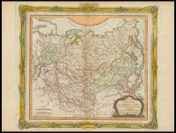
1730-1739, Dzungars as separate state, and the kingdom of Chinese Tartary
View attachment 36392
1750, and the Eluts are identified as a separate state
View attachment 36403
1766
View attachment 36397View attachment 36396
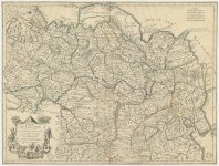
1770s, Calmuks aren't part of Chinese Tartary
View attachment 36393
View attachment 36394
1779 Calmuks/Eluths as part of Independent Tartary
View attachment 36391
1786, The dzungars are considered part of independent Tartary, although it's said that the Qing had already conquered the Dzungars in 1755–1759
View attachment 36400
Sometime in the late 18th century, and the Kalmyks still part of independent Tartary, even though their territory had shrunk
View attachment 36401
1798, independent tartary is still present but I don't see kalmyks
View attachment 36402
1799, now it's Chinese Tartary
Almost 50 years difference.
Let's conclude with the Dzungars. Perhaps I misinterpreted the maps, and that Chinese Tartary is, after all, part of China or Qing which is precisely why it is labeled as Chinese.
So I looked at some earlier maps
View attachment 36398View attachment 36399
1730-1739, Dzungars as separate state, and the kingdom of Chinese Tartary
View attachment 36392
1750, and the Eluts are identified as a separate state
View attachment 36403
1766
View attachment 36397View attachment 36396
1770s, Calmuks aren't part of Chinese Tartary
View attachment 36393
View attachment 36394
1779 Calmuks/Eluths as part of Independent Tartary
View attachment 36391
1786, The dzungars are considered part of independent Tartary, although it's said that the Qing had already conquered the Dzungars in 1755–1759
View attachment 36400
Sometime in the late 18th century, and the Kalmyks still part of independent Tartary, even though their territory had shrunk
View attachment 36401
1798, independent tartary is still present but I don't see kalmyks
View attachment 36402
1799, now it's Chinese Tartary
Almost 50 years difference.
When we look at the areas historically called Tartary, they all point to the same thing: the less developed, least known, and least populated parts of the world, both then and now. This is a perfect summary of Nikolai Morozov’s theory on the subject. I tend to agree with his general idea—that the flow of civilization moved from West to East, and not vice versa. Instead of Tartary being an ancient cradle of culture, it was actually the distant frontier that civilization reached last.
Tartaria: Nikolai Morozov
Introduction
In his multi-volume work
Christ, Nikolai A. Morozov presents a revolutionary reinterpretation of "Tartaria" (or Tataria). Historically mapped as a colossal East Asian empire ruled by nomadic Mongol-Tatar tribes, Tartaria is dismissed by Morozov as a "historical mirage" invented by medieval chroniclers.
Morozov argues that the events traditionally called the "Mongol-Tatar yoke" in Russia were not an Asian invasion. Instead, they were a series of Western European military and religious interventions originating from the Carpathian region. By analyzing historical timelines, military structures, and changing word pronunciations, Morozov claims that the narrative of an Eastern empire was constructed to hide the Roman Catholic origins of the early Russian state.
Discussion: The Carpathian Connection and the Western Yoke
To understand how an entire empire could be fabricated, Morozov decodes four major linguistic and geographic pillars of traditional medieval history:
| Traditional Historical Term | Morozov’s Reinterpretation | Historical Context |
| Tatar | Inhabitants of the Tatra Mountains | Central European forces (modern Poland, Slovakia, Hungary) rather than Gobi Desert nomads. |
| Horde | Latin Ordo (Knightly Orders) | Cruasading military contingents like the Teutonic or Livonian Knights. |
| Khan / Kha-kan | Khagan / Kogan (High Priest) | Pontifical representatives or the Roman Pope (Pontifex Maximus) himself. |
| Sarai (Volga Capital) | Sarajevo (Bosnia) or Adrianople | European political centers that were later "exiled" eastward on maps by 17th-century chroniclers. |
From "Tatras" to "Tatars"
The core of Morozov's theory relies on a linguistic link between the word "Tatar" and the Tatra Mountains in Central Europe. He asserts that Russian chroniclers originally used "Tatars" to describe military orders from the Carpathian region. Early Czech records referred to these invaders as
Tateri or
Tatrer. Over time, Orthodox clergy blended this with the Greek word
Tartaros (the underworld), transforming Western Catholic invaders into "filthy people from hell" to serve as religious propaganda.
Military "Hordes" as Latin "Orders"
Morozov argues that the military structure of the invaders was distinctly Western European. In his view, the word "Horde" is simply a distorted pronunciation of the Latin
Ordo (Order). The famous "Golden Horde" was actually the "Golden Order" (the Order of the Golden Cross). Its soldiers wore golden crosses on their armor and marched East during the Fourth Crusade to spread Catholicism among the Slavs.
The Papal Authority of the "Khans"
According to Morozov, the leadership of Tartaria trace back directly to the Roman Papacy. He claims that the title "Khan" is a shortened version of the biblical and Latin title for a high priest:
Kogan or
Pontifex. Under this framework, the "Great Khan" described by travelers like Marco Polo was actually the Pope, and local "Khans" were simply Catholic administrators. Even "Batu Khan" is reinterpreted as a play on
Batyushka or
Batyai—common Slavic terms for the Pope of Rome.
Moving the Capital: The Fictional "Sarai"
Morozov argues that the geography of Tartaria was retroactively altered in the 17th century under Russian Patriarch Nikon. He asserts that the Horde's capital, Sarai, was originally Sarajevo in Bosnia or a site near Adrianople. To erase the historical memory of Russia’s deep ties to the Catholic Church, later chroniclers "administratively exiled" these events to the Asian deserts, moving Sarai to the Volga River. Notably, the people living in the Volga region today never called themselves "Tatars" until the name was introduced in Russian schools during recent centuries.
Conclusion: The Reconstruction of History
Ultimately, Morozov portrays Great Tartaria as a massive historical fabrication. He concludes that the "Tatar yoke" was actually a period of Western European Catholic dominance over the Slavic East. This era ended not with the defeat of Asian nomads, but with Russia's geopolitical pivot back toward Greek Orthodoxy. By decoding these names and events, Morozov attempts to reclaim a "lost" chronology—one where the mysterious empire of the East is revealed to be nothing more than a shadow of the medieval West.