Oh do stop being offended on behalf of other people. It adds nothing to this thread. My questions were entirely on topic and the reply given didnt answer them. My response is honest and Lofwe wasnt offended.
Do these areas both here and in the Netherlands suffer from storm surges in modern times?
By modern times I mean from 1900 till the present day?
I recall some bloke suggesting that many valleys that today are river valleys were in earlier times actually lakes. When i remember his name and or where i come across it I'll add it in as it may help you.
I think he argues sea levels were higher and that was the reason for the lakes being there. It might well have a bearing on the damages to the old churches of which St Leonards is obviously one that was damaged.
Brain cell 346gt fired and i remebered his name Robert Langdon and here is his website;
Prehistoric Britain
The only historical event of any impact within this area of Essex was the Colchester earthquake late 1800’s that apparently shook a few houses and toppled a few chimney stacks. The alleged English civil wars bypassed this area. Regarding the Reformation, who knows!
For you information this area of Essex under study is predominantly rural agricultural land and is recognised as having been sparsely populated throughout it’s history, which is a little surprising when you consider it’s only an hour’s journey to London. Much (>50%) of the land is no more than 2m above chart datum and thus is protected by a sea wall (clay embankment) that encompasses the whole of the peninsular’s coastline. The remainder of the land is formed of soft rolling hills with a maximum height of 60m.
Storm surges deposit water onto land which drains back after a relatively short period following repairs to flood defences, if necessary, but they don’t deposit substantial depths of clay onto the land. It’s interesting to consider, what exactly is clay? Gravel, sand, silt and clay are all one and the same, formed from the same material, rock, it’s just a matter of scale depending on how long the material has spent in the grinder so to speak. Cataclysmic events, given enough kinetic energy, can liquify rock. For example let’s say a cataclysmic event in the Northern region of this world released sufficient energy to cause liquefaction of the lands and in turn caused a tsunami that washed through much of the Northern Hemisphere depositing beds of literally ground up everything, that we now refer to as clay beds. I’m not saying it did but hopefully you get my point, it’s possible.
I’m afraid that I don’t subscribe to the gobbledygook word salad nonsense referred to as Geology and most especially it’s alleged timeline, casting the formation of the lands we walk on back millions of years to rest in time periods sounding important only due to the difficulty in their pronunciation. I prefer to use common sense and rational thought.
Take a look at a geological map of Britain, is it not abundantly clear that the clay beds have washed in from the East? Consider for instance the beds of London Clay that form a large part of the East Coast, together with the Thames Valley and Estuary. If you were to exclude all the different types of clay from such maps
Replying to myself as it saves tablet typing, never fun.
The reasons why I asked those questions.
I have interest in the I and J and 1 dating discrepancies and have myself looked into them on maps and wall carvings, though only via digital photography, along with digital books and scans these investigations in concert with other members are in the archive somewhere.
The only non digital example I have come across is i have a mid 1700's book by Voltaire called The Life of Charles XII of Sweden. In there the I and the 1 are used for dating, no J.
The stones themselves are different sizes. The first extends beyond the photograph and has room for a lot more information about the person whose remains are underneath it.
Is there any additional information carved upon it on either side or is it just H S and J 777 ?
Do you presume the H and S refer to the Christian and Surname of the person?
Given the room for carving on that stone if its devoid of any other text that suggests a couple of things to me.
Whoever paid for or made the stone either didn't have the money for more carving or they wanted to hide or play down some scandal and arranged an out of parish burial.
Another possibility is there are two bodies buried their though I would have thought an 'and' would be between the H S.
Having examined the physical object does it look like the same hand carved text and numbers?
The other stone is physically much smaller and there is little room for anything else on that face of it. Does this stone have anything carvrc on the back face?
The reason for asking if theyy are located together is the possibility they have been moved at some point. Believe it or not fashion is a thing in graveyards. Its clearly visible in my local municipal cemetery.
The disparity in size is so marked that it is a possibility worth consdideration if they are located close together. If the headstones around them feature conventional 1 dating then its likely those pictured have either been moved as if they were of antiquity they would be closer to the church building as they would if they were graves of former clergy.
How close are they both to the church?
The smaller of the two is well into the degrading process in stark contrast to the latter is it made from different stone?
I suppose you have looked but in case you haven't have you read through any surviving parish registers, specifically the burial registers for this church?
These days if they survive they will likely be digitised but the digitising doesn't always add in margin notes.
When I began searching my genealogy in the early eighties I could request the actual registers at the Record Office in town and go see those they didn't have at the church's themselves. I could read the physical burial registers of the municipal cemetery but these days those records are no longer available to read openly.
I appreciate this church went out of use in 1973 but the registers may still be viewable in the Records office local to it.
Reason why the physical register is the thing to read is you may well find a margin note on the burial that sheds light on stones numbering, text and those buried.
I'm not telling you how to suck eggs just making suggestions and observations from my own experience of wandering around headstones.
This is interesting.
There is a clear, crystal clear, pattern in what you have found. Is there any correlation with prevailing wind and weather systems amongst these damaged and repaired churches?
If they werre all damaged in the same event it would be extraordinary and a clear indicator of the way storm and wind work on the stone work that faces the storm in that part of the island.
Or it could be a pattern of deliberate damage done to put the building beyond use. A destroyed Chancel does render a church useless.
I for one look forwards to you posting your findings from this most interesting endeavour.
Morning, good questions, I'll answer them in turn:
The two gravestones in question are in fact footstones rather than headstones. They are generally of a smaller size than their corresponding headstone and the information inscribed on them is therefor brief. Unfortunately in this instance their corresponding headstones are absent. Here's another few photos, again from local churchyards:
Next time I'm out and about I'll take some better photo's and publish so you get a better view. With regard to the footstone lettering, as in the case above, S - H, I don't presume anything but I can't imagine they would be anything other than the deceased's initials. Presumably there were rules to follow in terms of what was or was not allowed!
There is absolutely no doubt that the gravestones have been moved or disturbed in the past. Many of the graveyards themselves are in a complete mess, there are different datum levels everywhere, some graves appear raised others almost completely buried. If I didn't know better I would have wondered whether the whole site had been inundated with ~800mm of mud and dug-out after!! Photo below of the now deconsecrated church of St Lawrence, Asheldham (as an example).

Parish records I tend to avoid. Records exist simply because they're 'allowed' to remain in place. I distrust anything that could be a forgery or that may have been manipulated in any way. What is the veracity of old parish records? I'm not suggesting it's all fake but, you know, once bitten twice shy! So, under my remit, I choose to be risk averse wherever possible. My focus is what I can see with my own eyes and feel with my own touch because then you know it's real and tangible, that's knowledge. Under my historical analysis of the local churches I disregard anything that does not form part of the buildings fabric including fonts, plaques attached to walls and floors, etc as these items, which are often used for establishing dates, could have been transported there from the dark side of the moon as far as I'm concerned. Gravestones I would have normally discounted as well because as you say they may be non-local, however, that really isn't the point. Regardless of where these stones originated, Timbuctoo if you like, the essential point is that there existed a method of dating that differs from the modern form and most importantly, of which the modern record makes no mention. Forgery has certainly taken place because each of the 'J' dates are recorded in the Essex Archives with a 1 replacing the letter, similar to the 'I' dates. An important point to consider is what is not being said. The silence around this matter is deafening. There can only be one rational explanation and that's because the historical record is unable to defend its position and therefore HAS to remain silent, otherwise the occulted millennium shift would be exposed. You can't argue a point absent interaction from your opponent. Moving on...
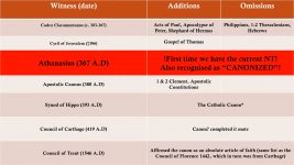
Regarding your interest in the church works, three tables below summarise the totality of the construction works, all taken from mainstream records (sorry about the colour scheme!):
Summarised as:
And:
And:
The prevailing wind is as you probably know from the south-west. These are substantial stone structures with buttressed walls so it's going to take a little more than a winter/summer storm to exact the extent of this past damage.
Another interesting fact relating to this 'historically non-eventful and peaceful mud bank' that I live on, which is incidentally made mention of in the Doomsday Book (make of that what you will!), is that various churches depicted on antique maps have disappeared, sort of memory holed. For instance churches that once stood at Snodham, Lawling and Ramsey Island. Further, the following churches were ruined and rebuilt on new sites, local to the old, where you can still find the original footprints and graveyards: Steeple, Mayland and Latchingdon.
Common sense demands a more robust explanation for what really is behind a litany of pretty catastrophic damage that's been occasioned to these old monuments. It requires a leap of faith!
Got to go, its the wife!!!!!!!
Interesting, in itself! We’re littered with obelisks and castles in the west & mid south. Have you noticed any basements in ‘Victorian/Georgian/Edwardian’ properties?
If Jesus is the light, and Julius is the sun, then they may be contemporaries ;-)
I am more inclined to think that they refer to a cosmological ‘starting point’.
This area is very rural. Prior to this drive by the authorities to build new houses on what was once protected greenbelt land there were very few buildings but lots of churches. There are very few of the allegedly Georgian buildings in the villages that dot this landscape. Some old structures in Burnham-on-Crouch but with the exception of the churches the old manor houses, called in these parts 'Halls', are generally found adjacent to the churches but I believe them to be mostly late 19th century. Not many basement round here I'm afraid,
I agree with regard to astrological events...
Sorry, I'm still getting used to this interface. Hopefully I'll tidy up.