- Joined
- Oct 5, 2020
- Messages
- 194
- Reaction score
- 875
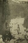
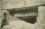
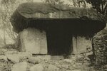
I found this situation of pyramids covered in mud interesting at the beginning of the 20th century. Besides that I did not know these Korean pyramids today in China, since for some reason we do not know much about the thousands of Chinese pyramids.
 The pyramid appears to be large enough to make this man look very tiny.

Janggun-chong or The General's Tomb is an ancient Korean pyramid, also known as the Eastern Pyramid. The pyramid is believed to be the burial tomb of King Gwanggaeto or his son King Jangsu, both former kings of Goguryeo.
The pyramid is located in what was formerly known as Gungnae, one of the capitals of Goguryeo, now Ji'an, Jilin Province, China. The pyramid was "rediscovered" in 1905.

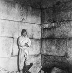
If they are huge blocks, these are the measurements ...
[Source: Encyclopedia of Korean Popular Culture (Janggunchong (將軍 塚))]

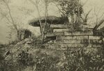
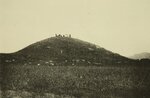
The same old question ...
How did they lift those rocks and cut the granite?
What happened in the 19th century for many of the pyramids that happened to be re-discovered in the 20th century. Were they full of mud?

In Mexico Leopoldo Batres, (Mexico City, 1852-1926) was a pioneer of modern archeology in Mexico, famous for his excavations during the Porfiriato.
Between 1884 and 1888, years in which he began his archaeological activity in Teotihuacan, where he exhumed the Temple of Agriculture, near the Pyramid of the Moon.
Other archaeological missions took him to Monte Albán and Mitla in Oaxaca in 1901-02, La Quemada, Zac. in 1903, Xochicalco, Mor. the Island of Sacrifices, Ver., again Teotihuacan between 1905 and 1910 and to the center of Mexico City.


Same situation with the pyramid of El Tajin (The city of thunder) Veracruz.
In 1785 the engineer Diego Ruiz visited and made a first description of the site while conducting an inspection looking for illegal tobacco fields.In the 19th century the site was visited by Guillermo Dupaix, Alexander von Humboldt and Carl Nebel, who published their notes on the place.
Carl Nebel's drawings of the Pyramid of Niches
The first archaeologists to arrive at the site in the 20th century included Teobert Maler, Eduard Georg Seler, Francisco del Paso y Troncoso, and Herbert Spinden and Ellen. With the discovery of oil in the area, roads were built from the 1920s through the 1940s.

I think it is between the late nineteenth and early twentieth centuries that these re-discoveries occur. In 1840 the American John Lloyd Stephens, in the company of the English artist Frederick Catherwood, visited the archaeological site of Chichén Itzá. At that time it was located within the ranch of the same name that belonged to Juan Sosa.In 1894, Edward Herbert Thompson acquired the Chichén-Itzá Hacienda and conducted studies and explorations in the area, especially within the sacred cenote. During these works, many objects found were improperly sent to the Peabody Museum of Archeology and Ethnology at Harvard University, although, later, and due to the intervention of the Mexican Government, some of the objects were returned. When Thompson died in 1935, the property passed to his heirs, although control and jurisdiction, as well as the systematic exploration and maintenance of the extensive archaeological site is in charge, by law, of the National Institute of Anthropology and History, a decentralized body. of the Mexican federal government. In 1860, French archaeologist Désiré Charnay traveled to Mexico, where he visited and photographed several of the Mayan ruins, including Palenque, Izamal, Chichén Itzá, Uxmal, Sisal, Dzitás, and Ticul, as well as the cities of Mérida and Campeche. Upon his return to France, he managed to mount an exhibition with the photographs taken in Mexico, which captured the attention of Parisian society, to the extent that Emperor Napoleon III sponsored in 1863 the edition of his book Cités et ruines americaines, where he described what learned in his travels and plates of his best photos were published.

Facade of the Temple of the Nuns, as it was in 1860. Photograph by Désiré Charnay.
Are we seeing the results of a cataclysm? The date 1915 to 1930 is important as well as KD said SH Archive - What happened between 1915 and 1930?
Sources:
http://encykorea.aks.ac.kr/Contents/Item/E0048318#https://es.wikipedia.org/wiki/Pirámide_de_Xi'Anhttps://es.wikipedia.org/wiki/Leopoldo_Batreshttps://es.wikipedia.org/wiki/El_Tajínhttps://es.wikipedia.org/wiki/Chichén_Itzá
The pyramid is located in what was formerly known as Gungnae, one of the capitals of Goguryeo, now Ji'an, Jilin Province, China. The pyramid was "rediscovered" in 1905.
[Source: Encyclopedia of Korean Popular Culture (Janggunchong (將軍 塚))]
1) A cemetery of a certain area was made by scattering fine gravel around the site where the external structural grave is located. Some estimate that there may be other barriers or stone walls, but the gravel is actually surrounded by a square of about 70 to 80 cm on one side as a sign of the collapse of the stone wall. ). Generally, the Jeokseok tombs in Goguryeo are simple Jeokseok tombs, Gidan Jeokseok tombs, and Gwak Jeokseok tombs with a type of single-stage stone chambers and bongseok stone tombs. According to this, the general tombs are included in the single-stage stone chambers. The tomb was made of granite in the shape of a 7-story pyramid. The stone was made by cutting granite into jangdaeseok [長 臺 石: rectangular cube] according to the standard, and then carefully polishing the surface. There are about 1,100 in total.
The size of the stone is not necessarily constant, but roughly the first layer uses a large stone, and it seems to gradually decrease as it goes up. The first floor has dimensions of about 2 m long and 1 m thick, while there are also about 2 m long and 0.7 m high. The largest jangdaeseok is 5.7 m long, 1.12 m wide and 1.1 m thick. On the second floor and higher, the thickness of the stone is reducing to about 0.5m. Also, at the bottom of each floor, there are some especially long jangdaeseoks about 5 to 6 m long. Looking at the number of levels of each floor that jangdaeseok is stacked on, the first floor has 4 levels, and each floor has 3 levels from the second to the seventh floor, and the upper jangdaeseok on the upper floor is convex to fix the jangdaeseok lower on the upper floor. Technically it is considered that it increases the solidity, for example, it makes it suitable for long seats. The top was rounded into a dome shape by mixing lime and gravel. The first floor of the tomb is square, the length of each side is 31.5 m, the height is 12.4 m and the area is 960m2.
The same old question ...
How did they lift those rocks and cut the granite?
What happened in the 19th century for many of the pyramids that happened to be re-discovered in the 20th century. Were they full of mud?
In Mexico Leopoldo Batres, (Mexico City, 1852-1926) was a pioneer of modern archeology in Mexico, famous for his excavations during the Porfiriato.
Between 1884 and 1888, years in which he began his archaeological activity in Teotihuacan, where he exhumed the Temple of Agriculture, near the Pyramid of the Moon.
Other archaeological missions took him to Monte Albán and Mitla in Oaxaca in 1901-02, La Quemada, Zac. in 1903, Xochicalco, Mor. the Island of Sacrifices, Ver., again Teotihuacan between 1905 and 1910 and to the center of Mexico City.
Same situation with the pyramid of El Tajin (The city of thunder) Veracruz.
In 1785 the engineer Diego Ruiz visited and made a first description of the site while conducting an inspection looking for illegal tobacco fields.In the 19th century the site was visited by Guillermo Dupaix, Alexander von Humboldt and Carl Nebel, who published their notes on the place.
Carl Nebel's drawings of the Pyramid of Niches
The first archaeologists to arrive at the site in the 20th century included Teobert Maler, Eduard Georg Seler, Francisco del Paso y Troncoso, and Herbert Spinden and Ellen. With the discovery of oil in the area, roads were built from the 1920s through the 1940s.
I think it is between the late nineteenth and early twentieth centuries that these re-discoveries occur. In 1840 the American John Lloyd Stephens, in the company of the English artist Frederick Catherwood, visited the archaeological site of Chichén Itzá. At that time it was located within the ranch of the same name that belonged to Juan Sosa.In 1894, Edward Herbert Thompson acquired the Chichén-Itzá Hacienda and conducted studies and explorations in the area, especially within the sacred cenote. During these works, many objects found were improperly sent to the Peabody Museum of Archeology and Ethnology at Harvard University, although, later, and due to the intervention of the Mexican Government, some of the objects were returned. When Thompson died in 1935, the property passed to his heirs, although control and jurisdiction, as well as the systematic exploration and maintenance of the extensive archaeological site is in charge, by law, of the National Institute of Anthropology and History, a decentralized body. of the Mexican federal government. In 1860, French archaeologist Désiré Charnay traveled to Mexico, where he visited and photographed several of the Mayan ruins, including Palenque, Izamal, Chichén Itzá, Uxmal, Sisal, Dzitás, and Ticul, as well as the cities of Mérida and Campeche. Upon his return to France, he managed to mount an exhibition with the photographs taken in Mexico, which captured the attention of Parisian society, to the extent that Emperor Napoleon III sponsored in 1863 the edition of his book Cités et ruines americaines, where he described what learned in his travels and plates of his best photos were published.
Facade of the Temple of the Nuns, as it was in 1860. Photograph by Désiré Charnay.
Are we seeing the results of a cataclysm? The date 1915 to 1930 is important as well as KD said SH Archive - What happened between 1915 and 1930?
Sources:
http://encykorea.aks.ac.kr/Contents/Item/E0048318#https://es.wikipedia.org/wiki/Pirámide_de_Xi'Anhttps://es.wikipedia.org/wiki/Leopoldo_Batreshttps://es.wikipedia.org/wiki/El_Tajínhttps://es.wikipedia.org/wiki/Chichén_Itzá