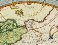
This is all very interesting. There's the Mare Septentrionalis in 1576 and most of North America is marked Septentrionalis around this time and onwards for a century or more at least into the 1600s and on into the 1700s if memory serves.
Septentrionalis means seven tribunals in Latin so there's a theory this was the name of a legal jurisdiction or empire. Or maybe a trading empire. Or even just a banking and justice system within which fair trade was possible.
I checked the Latin and trionalis means every three years - triennial. 'Tribunal' is actually a Latin word that we still use unchanged in modern English. I wonder if this is the opposite of our system of Babylonian debt slavery - a trading system in which every debt must be cleared within three years so the accumulation of 90% of everything into a few hands wasn't possible.

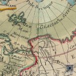
There appear to have been WMDs used in the Tartaria region around 1816, see this thread Destruction of Tartaria
And maps stopped showing Tartaria some time after that. There's also a Scythian ocean, other forum members seem to know more about the Scythians than I do.
Septentrionalis means seven tribunals in Latin so there's a theory this was the name of a legal jurisdiction or empire. Or maybe a trading empire. Or even just a banking and justice system within which fair trade was possible.
I checked the Latin and trionalis means every three years - triennial. 'Tribunal' is actually a Latin word that we still use unchanged in modern English. I wonder if this is the opposite of our system of Babylonian debt slavery - a trading system in which every debt must be cleared within three years so the accumulation of 90% of everything into a few hands wasn't possible.
There appear to have been WMDs used in the Tartaria region around 1816, see this thread Destruction of Tartaria
And maps stopped showing Tartaria some time after that. There's also a Scythian ocean, other forum members seem to know more about the Scythians than I do.