- Joined
- Aug 22, 2022
- Messages
- 116
- Reaction score
- 250
My theory so far: the recent history of the British Isles has been hijacked, and disaggregated so that the invaders' destruction is blamed on various other parties, including the indigenous population. The relentless, brutal attacks on man, beast, and building, and internal subterfuge, blackmail and bribery have proved successful, and the natives are now captured in the invaders' web of privileges and rights, to be dispensed and withdrawn on a whim. Britain's ancient history has been largely obliterated or consigned to mythology.
Questions remain: what happened to the true nobility and House of Wessex?
Alfred's Tower
I became fascinated by Alfred’s Tower (51°06′53″N, 2°21′54″W) when I came across a statue of King Alfred, otherwise known as Alfred the Great, a third of the way up on its north-eastern face. Another post has more details on the possible relationship between King Edward VII, King Alfred and Queen Elizabeth.
This beautiful triangular tower is massively solid, yet elegant, almost chateau-like with its pointed west turret. An impressive 48m/160ft tall - that’s 18-20 floors high! - it is set in a commanding position at the end of a long, high ridge in Wiltshire, looking west over Somerset and Dorset. It is not a well-known monument, and seems to have been largely forgotten, which in itself is strange. It is an iconic structure.


The site is managed by the suspect National Trust, a charitable organisation that manages a lot of British heritage sites. It acknowledges that King Alfred the Great’s army was once here, and I suspect that his son King Edward was familiar with the place:

It seems that the National Trust would prefer it if you got in your car, drove down to their box office, cafe and shop, and spent your two and a half hours there.

Viewed from a distance, it is striking, but the trees don’t allow you to appreciate the scale of it. Not that I would like the trees to be chopped down, but I’m just saying that If They wanted to, They would have.
Below is the map provided by the National Trust. It wasn’t until a few days later that I looked at the place names closely, and, to be honest, they turned my stomach, and I’m glad I didn’t notice when I was visiting.

Six Wells Bottom & St. Peter’s Pump
The centre of the map has areas called Lynch Wood, Sunny Hanging and Shady Hanging. There is also Hilcombe Hanging, by Alfred’s Tower, and White Sheet Hill is about three miles to the east.

This is Six Wells Bottom, looking along the top red/blue path on the map above, from left to right. Shady Hanging is to the left, with Sunny Hanging to the right of the gentle valley. From the corresponding angle of the sun, we can surmise that the hangings took place in summer.

Despite being called Six Wells Bottom, there are no longer any discernible wells except for this rather hideous mess, with an old world cherry on the top. It is at the other end of the valley, just visible a kilometre away in the middle of the photo above. This is St Peter’s Pump:

The name St. Peter gives a clear Catholic connection. The pump’s story is that it was made in 1474 and placed near to St Peter's Church in Bristol, a port city 35 miles away, where it was originally dedicated to St. Agnes or St Edith. It was removed in 1766, and placed here two years later, by Henry Hoare, on a grotto base over one of the springs that form the source of the River Stour. It certainly is not functioning - it’s hard to see how it would function - and the shoddy, scruffy walls are not in keeping with the smart, old buildings around.
Perhaps the name references St. Peter’s Pence? Peter’s Pence is the name given to donations or payments made directly to the Holy See of the Catholic Church, a practice which arose first in England, and was/is basically a tax. The pillaging of Wessex’s nobility would certainly swell the coffers of the victors, pumping considerable wealth into their currency. Maybe it even seals the well where the bodies were thrown, like a gruesome trophy photograph taken by a murderous psychopath of his victim’s secret burial place.
It is either coincidence or confirmation that the Hoares, professed owners of Stourhead Park since the early 1700’s, are the founding family of C. Hoare & Co., the oldest private bank in England, which is still thriving today, primarily serving high-net-worth families and individuals.
Okay, all this is circumstantial evidence - we need something more.
Stourhead House Inscription
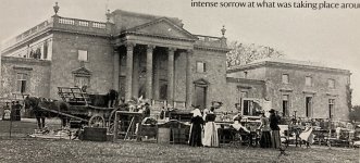
Stourhead House, as the name implies, lies at the head of the River Stour, which rises in Six Wells Bottom. It is rather plain as stately homes go, but in a secure location on the same high ridge as Alfred’s Tower, with a fresh water supply that can be controlled and protected from poisoning.

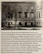
However, at the rear of the building that I found something … chilling.
The back of the house is quite nice, with a wall-edged ha-ha, maybe once a moat, about fifty metres from the house, and a view along the ridge to a 100ft/ 32m tall stone obelisk. Following the ridge beyond the obelisk takes you round to Alfred’s Tower.


On the central pediment of the house, there is a Latin inscription, under a double-headed eagle; both associated with the Holy Roman Empire, and distinctly non-native.
 Although it is difficult to make out some of the text, due to the angle of the photograph, it is possible to make out:
Say What ???????
Finally, I would like to add that this is a novel theory, to my knowledge, just in case the Watchers have been persuaded by the Parasitic Ruling Class that We, the people, are fine with having our noble ancestors slaughtered, and replaced with evil personified. Attempts appear to have been made to allow for both “hidden in plain sight” with clues still on display, and simultaneously “plausible deniability “. I live in hope for retribution for their sins, and I hope you got that, Watchers!
Questions remain: what happened to the true nobility and House of Wessex?
Alfred's Tower
I became fascinated by Alfred’s Tower (51°06′53″N, 2°21′54″W) when I came across a statue of King Alfred, otherwise known as Alfred the Great, a third of the way up on its north-eastern face. Another post has more details on the possible relationship between King Edward VII, King Alfred and Queen Elizabeth.
This beautiful triangular tower is massively solid, yet elegant, almost chateau-like with its pointed west turret. An impressive 48m/160ft tall - that’s 18-20 floors high! - it is set in a commanding position at the end of a long, high ridge in Wiltshire, looking west over Somerset and Dorset. It is not a well-known monument, and seems to have been largely forgotten, which in itself is strange. It is an iconic structure.
The site is managed by the suspect National Trust, a charitable organisation that manages a lot of British heritage sites. It acknowledges that King Alfred the Great’s army was once here, and I suspect that his son King Edward was familiar with the place:
It seems that the National Trust would prefer it if you got in your car, drove down to their box office, cafe and shop, and spent your two and a half hours there.
Viewed from a distance, it is striking, but the trees don’t allow you to appreciate the scale of it. Not that I would like the trees to be chopped down, but I’m just saying that If They wanted to, They would have.
Below is the map provided by the National Trust. It wasn’t until a few days later that I looked at the place names closely, and, to be honest, they turned my stomach, and I’m glad I didn’t notice when I was visiting.
Six Wells Bottom & St. Peter’s Pump
The centre of the map has areas called Lynch Wood, Sunny Hanging and Shady Hanging. There is also Hilcombe Hanging, by Alfred’s Tower, and White Sheet Hill is about three miles to the east.
This is Six Wells Bottom, looking along the top red/blue path on the map above, from left to right. Shady Hanging is to the left, with Sunny Hanging to the right of the gentle valley. From the corresponding angle of the sun, we can surmise that the hangings took place in summer.
Despite being called Six Wells Bottom, there are no longer any discernible wells except for this rather hideous mess, with an old world cherry on the top. It is at the other end of the valley, just visible a kilometre away in the middle of the photo above. This is St Peter’s Pump:
The name St. Peter gives a clear Catholic connection. The pump’s story is that it was made in 1474 and placed near to St Peter's Church in Bristol, a port city 35 miles away, where it was originally dedicated to St. Agnes or St Edith. It was removed in 1766, and placed here two years later, by Henry Hoare, on a grotto base over one of the springs that form the source of the River Stour. It certainly is not functioning - it’s hard to see how it would function - and the shoddy, scruffy walls are not in keeping with the smart, old buildings around.
Perhaps the name references St. Peter’s Pence? Peter’s Pence is the name given to donations or payments made directly to the Holy See of the Catholic Church, a practice which arose first in England, and was/is basically a tax. The pillaging of Wessex’s nobility would certainly swell the coffers of the victors, pumping considerable wealth into their currency. Maybe it even seals the well where the bodies were thrown, like a gruesome trophy photograph taken by a murderous psychopath of his victim’s secret burial place.
It is either coincidence or confirmation that the Hoares, professed owners of Stourhead Park since the early 1700’s, are the founding family of C. Hoare & Co., the oldest private bank in England, which is still thriving today, primarily serving high-net-worth families and individuals.
Okay, all this is circumstantial evidence - we need something more.
Stourhead House Inscription
Stourhead House, as the name implies, lies at the head of the River Stour, which rises in Six Wells Bottom. It is rather plain as stately homes go, but in a secure location on the same high ridge as Alfred’s Tower, with a fresh water supply that can be controlled and protected from poisoning.
However, at the rear of the building that I found something … chilling.
The back of the house is quite nice, with a wall-edged ha-ha, maybe once a moat, about fifty metres from the house, and a view along the ridge to a 100ft/ 32m tall stone obelisk. Following the ridge beyond the obelisk takes you round to Alfred’s Tower.
On the central pediment of the house, there is a Latin inscription, under a double-headed eagle; both associated with the Holy Roman Empire, and distinctly non-native.
VASTATAS A.D. 1902 RESTAURAVIT ——AD1903
or
LAID TO WASTE 1902 RESTORED 1903
or
LAID TO WASTE 1902 RESTORED 1903
Say What ???????
Finally, I would like to add that this is a novel theory, to my knowledge, just in case the Watchers have been persuaded by the Parasitic Ruling Class that We, the people, are fine with having our noble ancestors slaughtered, and replaced with evil personified. Attempts appear to have been made to allow for both “hidden in plain sight” with clues still on display, and simultaneously “plausible deniability “. I live in hope for retribution for their sins, and I hope you got that, Watchers!