SH Archive What happened to the Siberian forests 200 years ago?

SH.org OP Username
KorbenDallas
SH.org OP Date
2018-04-12 03:34:50
SH.org Reaction Score
19
SH.org Reply Count
11

KD Archive

Not actually KorbenDallas
Active Member
Joined
Sep 22, 2020
Messages
4,691
Reaction score
1,500
This is interesting how one topic leads to another. This time I came across some information about the Siberian Taiga Forests. Apparently the age of the Siberian Forests is estimated to be around or under 200 years. This is somewhat bizarre because the Siberian region was, for the most part, an uncharted territory well into the early stages of the 20th century. The lifetime of the Siberian Pine can reach up to 850 years. There are plenty of other trees out there whose lifespan is around 500-600 years. Yet the Siberian forests are estimated to be approximately 200 years old. This is explained by major wild fires happening from time to time. The above explanation is very convenient for some areas, but can not account for the entire Siberian region.

With an area of 13.1 million square kilometres (5,100,000 sq mi), Siberia accounts for 77% of Russia's land area, but it is home to just 40 million people—27% of the country's population.

siberia_map_outline.jpg

I do not think that total, human infused deforestation of such a vast region was possible in the 19th, or early 20th century. Demographic data simply does not support it. As it was mentioned above, current population of Siberia is approximately 40 million people. You can reference Geography of Siberia to see that there were barely any people out there.

Also, I think this issue of "200 year old trees" will encompass way more than just Russian Siberia. A fairly good portion of the Northern Hemisphere above, approximately, the 40th parallel north, could be affected. That I will try to elaborate on later in this article.

First thing we need to understand that areas kin to California Redwood Forests, Oregon Redwoods Trail, and Quinault Rain Forest Valley on the Olympic peninsular are rare exceptions.

redwood_ca_1.jpgredwood_ca_2.jpgredwood_ca_3.jpgredwood_ca_4.jpg

There is probably a reason why the above are located within the same coastal vicinity anyways.

TallestTrees.jpg
Also we do have some old trees in various locations, but those are single occurrences, and usually have some sort of a commemorative plaque next to them.

tree_plaque_1.jpgtree_plaque_2.jpg

To gain some sort of an understanding of how old a tree is, I would like to recommend this Tree Age Calculator. It might surprise you, when you plug in the tree data on your local "big" tree. It just might be that it is only 75 years old.

tree_age_1.pngtree_age_2.pngtree_age_3.png

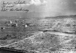
Well, let's get back to the Siberian issue. We will start with the 1908 Tunguska Meteorite. The event itself is not in question here. Mind that there was no known commercial, or any other type of logging activity conducted in this remote area.

tunguska_event_map.jpg

We will simply inspect some damages to the surrounding vegetation.

tunguska_meteor_1.jpgtunguska_meteor_3.jpgtunguska_meteor_2.jpg
It can be clearly seen in the above photos that the trees in the area were fairly young in 1908. Their size uniformity indicates that they were of approximately the same age. No huge old trees can be seen. You are welcome to google-check for your self.

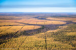
Now let us look at some of the photos of the Siberian region attributed to the early 20th, and late 19th centuries.

siberia_0.jpgsiberia_1.jpgsiberia_2.jpgsiberia_3.jpgsiberia_4.jpgsiberia_5.jpgsiberia_7.jpgsiberia_7.jpgsiberia_8.pngsiberia_9.jpgsiberia_10.jpgsiberia_11.jpgsiberia_12.jpgsiberia_13.jpgsiberia_14.jpgsiberia_15.jpgsiberia_16.jpgsiberia_17.jpgsiberia_18.jpgsiberia_19.jpgsiberia_20.jpgsiberia_6.jpg


In the above photos is Russian Taiga approximately 100-120 years ago. Just below are the photos of the same vicinity but taken recently. It is estimated that an average age of the forests in Siberia is just under 200 years old.

new_siberia_3.jpgnew_siberia_2.jpgnew_siberia_5.jpgnew_siberia_7.jpgnew_siberia_1.jpg
new_siberia_6.jpgnew_siberia_4.jpgnew_siberia_8.jpgnew_siberia_9.jpgnew_siberia_10.jpg

Below you can see a tree life expectancy table I google-translated. But I do not see those 500 year old forests in the pictures above. And there can be none, because there were very young trees in Siberia in the beginning of the 20th century. If you want to see what a 500 year old tree looks like, here they are, all stand alone. They are rare and protected.

Tree_Age-1.jpgTree_Age-2.jpgTree_Age-3.jpg
While natural explanations, like fires and logging are plausible enough, it is also naive to think that all the woods recycled themselves one way or the other. Of course for the lack of a better explanation we have to accept the "fire and logging" theory.

Bizarre Fire Breaks

And than you have these bizarre fire break type perpendicular lines cut through different chunks of wilderness. And those lines do not care whether they go through a river or over a hill. They just stay straight and perpendicular to each other. I have no clue what kind of technology was used to line those up. How do you cut those through the Siberian forest, and what for? The area below is 10x12 miles, but there are tons of those. One of the images has grid lines in case you want to find it on your Google Earth.

Map_grid_siberia.jpgMap_grid_siberia_1.jpg

* * *
There is one place in Europe where multiple old trees were located. Of course our scientists assigned them a non-surprising age of 8,000,000 years old. Yes, this is supposedly the age of the stumps you can see below. They were dug out from under feet of sand and dirt in Hungary. Non-fossilized but yet they are supposed to be dinosaur old.

stump_prehistoric_1.jpgstump_prehistoric_2.jpgstump_prehistoric_3.jpgstump_prehistoric_4.jpgstump_prehistoric_5.jpgstump_prehistoric_6.jpg
This way the first floors of the buildings in this article also have to be 8,000,000 years old: Mud flood, dirt rain, and the story of the buried buildings. Jokes aside, I think that a very similar "mud flood"event caused the death of these trees.

* * * * *

Then I googled for some pictures of Washington state, along the I-90 corridor, west of snoqualmie.

snoqualmie-washington_1.jpgsnoqualmie-washington_2.jpgsnoqualmie-washington_3.jpgsnoqualmie-washington_4.jpgsnoqualmie-washington_5.jpgsnoqualmie-washington_6.JPG
But guess what, they are not over 200 years old either. Using the same tree age calculator, they might be close to a certain degree. I did see some bigger trees out when hiking, but they are very rare and hardly reach 300 years old. The mass is definitely within 200 years. Surely, no logging was done there 200 years ago. There could be none in 1820s.

Here is a few older photos of some locations in the state of Washington.

usa_forests_1.pngusa_forests_2.pngold_washington_trees_1.jpgold_washington_trees_2.jpgold_washington_trees_3.jpg

Once again, there are some old trees, but there is no forest of old trees. If you go up higher to the Mt. Rainier National Park you can see some huge Douglas Fur trees at the Grove of Patriarchs. The area is snow free June through October, and the elevation is 2,200 feet. Some of the furs are claimed to be thousands years old. But the area where they grow is very small. It proves that old trees used to be in the area. A few survived, and the rest did not.

Mount+Rainier+National+Park_douglas_Fur_1.jpgMount+Rainier+National+Park_douglas_Fur_2.JPGMount+Rainier+National+Park_douglas_Fur_3.jpgMount+Rainier+National+Park_douglas_Fur_4.jpg

The uniformity of the other "all over the place" forests suggests a much younger age. Considering that the life span of the majority of the evergreens is pushing 650-900 years, this is bizarre. Of course if you do not consider another bizarre fact: the map shenanigans of the North American continent.

Below I display several iterations of North America as presented by our ancestors. Watch the progression from one map to the next. Time makes a huge difference.

Map date: 1564 - 1570 - 1590 - 1630 - 1642 - 1647 - 1694 - 1716 - 1744 - 1797 - 1847

1564_map_america.jpg1570_map_america.jpg1590_map_america.png1630_map_america.jpg1642_map_america.jpg1647_map_america.jpg
1694_map_america.jpg1716_map_america.jpg1744_map_america.jpg1797_map_america.jpg1847_map_america.jpg

It appears that a very long time ago, in the 16th century, there was a specific understanding of the outline of the North American Continent. But then something happened and the area became Terra Incognita. With time it was rediscovered and thus it reappeared on the map, this time with a differently looking outline. Could this be an event related to the other weird geographical, and urban transformations like the emergence of Sahara Desert and burial of the buildings? May be it could.

Is it possible this event killed huge tree masses in the Northern Hemisphere. I think it is.

P.S. question: do you have old forests with 500+ year old trees in your area? (forests, and not single trees)
Note: This OP was recovered from the Maxine archive.
 
Да, есть такая загадка.
1) На фотографиях видно, что вокруг городов нет лесов или они небольшие.
2) Теперь леса выросли :)
Даже если взять деревни, где рубят дерьмо для обогрева, а коровы жуют молодые деревья ... Трава и деревья по-прежнему занимают территорию, и весь скот не может их съесть.
3) Еще странный факт, что леса выросли недалеко от полярного круга.
Раньше говорили, что там только карликовые леса и т.д.
Сейчас что-то эти леса соизволят вырасти :))

4) Есть подозрительные поляны, линии.
Очень похоже на каналы, железные дороги или дороги, кварталы города.
Тема - «прямые дороги».
Человек не может делать их на этом уровне.

Да, при Сталине были программы по искусственному созданию лесов против пустынь.

Но такой масштаб пересеченных линий невозможен :)
 

Attachments

  • 2102_900.jpg
    2102_900.jpg
    209 KB · Views: 627
  • AMiHHvQp35rJS7B8MZoAXnVzWlomVxmOqDJJBR1Op9D-kxGqaRk_ns0qx3eqhT57ryHn_C6GHT9U91O2BgGYiEGTeHZEI...jpeg
    AMiHHvQp35rJS7B8MZoAXnVzWlomVxmOqDJJBR1Op9D-kxGqaRk_ns0qx3eqhT57ryHn_C6GHT9U91O2BgGYiEGTeHZEI...jpeg
    309.4 KB · Views: 590
Да, есть такая загадка.
1) На фотографиях видно, что вокруг городов нет лесов или они небольшие.
2) Теперь леса выросли :)
Даже если взять деревни, где рубят дерьмо для обогрева, а коровы жуют молодые деревья ... Трава и деревья по-прежнему занимают территорию, и весь скот не может их съесть.
3) Еще странный факт, что леса выросли недалеко от полярного круга.
Раньше говорили, что там только карликовые леса и т.д.
Сейчас что-то эти леса соизволят вырасти :))

4) Есть подозрительные поляны, линии.
Очень похоже на каналы, железные дороги или дороги, кварталы города.
Тема - «прямые дороги».
Человек не может делать их на этом уровне.

Да, при Сталине были программы по искусственному созданию лесов против пустынь.

Но такой масштаб пересеченных линий невозможен :)

Translated with Google-

Yes, there is such a riddle.
1) The photographs show that there are no forests around the cities or they are small.
2) Now the forests have grown :)
Even if you take the villages where shit is cut for heating, and cows are chewing young trees ... Grass and trees still occupy the territory, and all livestock cannot eat them.
3) Another strange fact is that the forests grew [grow?] near the Arctic Circle.
They used to say that there are only dwarf forests, etc.
Now something these forests will deign to grow :))


4) There are suspicious glades, lines.
It is very similar to canals, railways or roads, city blocks.
The topic is “straight roads”.
A person cannot do them at this level.

Yes, under Stalin there were programs to artificially create forests against deserts.

But such a scale of crossed lines is impossible:)
====================

I added the bold emphasis and the questionable translation grew or grow. The rest of the translated khaoz text implies that trees are growing further North now where they didn't before.

Keeping in mind all of the above and the KD original, there is an addition factor to consider. A C3 tree of any type can only grow when, along with lesser conditions such as nitrogen, micronutrients, proper soil, etc., these four key conditions are met:
  • Light (the Sun)
  • Temperature
  • Water
  • Atmospheric CO2
Of these four, the one that has changed, and dramatically, over the past 200 years is Atmospheric CO2. It has risen from about 280 ppm in 1820 to about 415 ppm today. (At about 120 ppm, C3 trees stop growing and die. Almost all tress are C3 trees.)

So perhaps trees that were formerly marginal became viable in Siberia due to the increased CO2 level. Some background on this, particularly Part 7. That probably can't account for the 200 year old trees, but it can for the more recent push into the Arctic. This also shows up in the satellite data, 1982-present, as an increase in leaf area.
 
bout the Arctic Circle, I mean the tundra. There used to be a dwarf forest and tundra near the Arctic Circle.
Before = 50 years ago. Now all of a sudden the trees began to grow normally. And this is preserved in the books of the 60-80s :)

How can CO-2 influence?
-) Recently there was a Volcano ejection in Iceland, and all aircraft flight instruments were jammed.
Why torment countries with quotas when they can throw out so many substances in one week. There is no science in this.
You've all read about it yourself with criticism of the CO2 lobby.
-) Many areas are affected by the "permafrost" in the ground.
And who said that this is a normal state of the earth, maybe there should be palm trees and jungles growing?
Yes, now scientists are running around and saying that the permafrost is melting, bacteria are millions of years old and horror.
Another example is Mammoths (ELEPHANTS) completely intact and dead IN ONE MOMENT (!).
Plus, they are canned like cucumbers.

I don't think you can measure the CO2 level in 1820. (A lot of lies about the 19th century)
Experiments can only be done in reality.
You can measure the weather at the weather station. When scientists start talking about all sorts of laboratory methods, it's funny.
As an example, the plane was left in the ice of Iceland on the Glacier, and it sank tens of meters deep. Geologists must say that it is millions of years old :)

This is what I was looking for-

"Before = 50 years ago. Now all of a sudden the trees began to grow normally. And this is preserved in the books of the 60-80s"

Too bad we can't have any of these books.

I'd like to add it to my list of Signs of the Greening of the Earth. This can be hard to recognize because it is happening slowly and is diffused over all the lands. Twice the total vegetation mass in the United States has already been added, but it's spread out over the entire planet. Some examples-

Blackout. Look at shadows of trees and bushes. Are they completely black? Then the plant is intercepting every ray of sunlight. Did they used to do this, years and decades ago?

Wall of green. Rows of trees along roads that have grown together to block the Sun, from the ground up, along with all the little stuff in front of the trees. Dark as a cave inside.

Old tree, new branch. Are older, mostly deciduous, trees now sprouting new branches lower down on their trunks, more than they used to?

Arboreal Reconquista. Have you seen grasslands that are being invaded and taken over by new trees? In Idaho and Wisconsin, the state is actively trying to counter this.

Before-After. Do you have any sets of new and old pictures of a natural, untouched landscape, both taken from the same point of view? The old ones are preferably several decades old.
 
https://stolenhistory.net/threads/about-atlantis-and-north-boreal-deluge.1019/
So 200 years ago. That points 1500s 1600s magnetic center being relocated.
Probably 1400s as Greenland was abandoned on those days as unhabitable.
That means ICE PLATE was being moved from ALASKA to current GREENLAND.

Greenland around 1000 thousand years, was habitable.

The Norse population disappeared from Greenland in around 1500 AD for reasons that have never been fully explained – although countless well-founded theories about their disappearance still flourish today. Many of the Norse settlers’ ruins are still visible on plains and mountainsides in South Greenland and at Nuuk.

Why to name Greenland an island full of ice. Maybe was not covered by ice in the past (almost till around 1400s-1500s). Climate changed.
Alaska ice plate has been moved since then to Greenland, affecting north atlantic sea current.

In the same events I guess, a great tectonic activity, involving some Iceland volcanos very active.

https://en.wikipedia.org/wiki/List_of_large_volcanic_eruptions
Candidte is

The Veiðivötn eruption in 1477 is the largest known Icelandic eruption.

https://en.wikipedia.org/wiki/Bárðarbunga
This could explain since then, there are lots of islands sunk in the north atlantic path linking europe to americas.
Such as Frisland Island or Frisia or Saint Borondon Island "legend" (Brennan)

Frisland.jpg

Maps prior to 1500s-1400s shows an habitable island (not only in the south), and they show rivers (what should be impossible under perpetual ices).

Greeland.jpg
s-l1000.jpg

http://www.newyorkmapsociety.org/LTMysteriousMapmakers.html
Handmade_Greenland_Coptic_Bound_Book.png

Atlantis and Greenland Lost (unhabitable), myths mixed.

%2F98%2Fcc%2F12%2F98cc12d2be49db399d2ac15950618ccb.jpg

And that by the way explains why US WEST COAST was colonised so late (full of ice till medium california).

There are lots of maps like that

mollatlantis.jpg


Not only that, even we have the cultural tradition and consideration of north pole and california as a paradise place linked.
https://www.africaresource.com/rast...lifiacalafia-the-black-empress-of-california/
California Regio

uEVB9cp.png
rnia-state-flag-141482581-59a34ff50d327a00103d6690.jpg

Even in the flag (north polar star), and the bear.

So ice plate has being moved from ALASKA to GREENLAND in very recent times, not "millions of years". As north magnetic pole moving suggest.
It's interesting the ancient monuments allignment taking ANCHORAGE as a central point.

bVp5X6g.png

More interesting to correlate ANKH and Anchorage (Anchorage symbol is an Anchor).
California, Washington Columbia State, and northern territories, wasn't colonised till 1700s-1800s.

Yukon Gold fever is very recently. As ICE were dissappearing.
Klondike Gold Rush

It's strange as the official historians abuses of the so call "Black Legend" attribuited to Spain (And why the hell did not spanish steal that gold before?).

Alaska south bays are not so cold (specially in spring, summer and autumn), there is a microclimate due to pacific ocean warm waters anomalie.
research.jisao.washington.edu/pdo/

Maybe this anomalie was formed then some centuries ago.

It explains lack of detailed map in western america.

RQoCGbk.png
KDyXDW1.png

And it could explain geological history of Montana, and western north america ancient rivers changes.
And of course changes involving CALIFORNIA ISLAND being transformed in a peninsula.

mxRMR4j.png
CBPR51z.png

And the most giants trees in the world (like a new virgin territory), the Secuoyas, once ice retired.


This theory of north magnetics moving, and drifting the ice place, has some points of support.

Chichen Itza (Mesoamerican Pyramids are newers that Egypt), points Greenland (maybe a recording of these magnetics moving 500-600 years ago).


View: https://www.youtube.com/watch?v=oO6cIZsi-cM


But not millions of years as officialist Mario Buildreps sentences.


View: https://www.youtube.com/watch?v=tOl4r9ehTA4


For spanish and first europeans recolonisers, the territory of California is called NEW CALIFORNIA.

bL2MHre.png

https://www.ancient-origins.net/myths-legends-americas/search-cibola-seven-cities-gold-002603
AMERIKA as a land of "milk and honey".

So we have involved ICE PLATE MOVING, and a sort of disaster in boreal areas that burnt down the trees. And actually all trees in northern boreal areas has around only 200 years.

https://en.wikipedia.org/wiki/Boreal_forest_of_Canada
CFS_Boreal_876px_E.jpg

Is canadian forest ancient? NO. the same for siberian trees (around 200 years).
http://cfs.nrcan.gc.ca/publications?id=30085
We could say there was a problem around 1500s. Then, after 200 years of muddy lands, trees reflourished again.
A magnetic relocation and a very violent climate changes, with a sort of mud flood from north pole areas, devastating all around.

576d3ebcf3271.jpg

Officialist trying to square the circle.
https://phys.org/news/2016-06-siberian-larch-forests-linked-ice.html
 
Last edited by a moderator:
bout the Arctic Circle, I mean the tundra. There used to be a dwarf forest and tundra near the Arctic Circle.
Before = 50 years ago. Now all of a sudden the trees began to grow normally. And this is preserved in the books of the 60-80s :)

How can CO-2 influence?
-) Recently there was a Volcano ejection in Iceland, and all aircraft flight instruments were jammed.
Why torment countries with quotas when they can throw out so many substances in one week. There is no science in this.
You've all read about it yourself with criticism of the CO2 lobby.
-) Many areas are affected by the "permafrost" in the ground.
And who said that this is a normal state of the earth, maybe there should be palm trees and jungles growing?
Yes, now scientists are running around and saying that the permafrost is melting, bacteria are millions of years old and horror.
Another example is Mammoths (ELEPHANTS) completely intact and dead IN ONE MOMENT (!).
Plus, they are canned like cucumbers.

I don't think you can measure the CO2 level in 1820. (A lot of lies about the 19th century)
Experiments can only be done in reality.
You can measure the weather at the weather station. When scientists start talking about all sorts of laboratory methods, it's funny.
As an example, the plane was left in the ice of Iceland on the Glacier, and it sank tens of meters deep. Geologists must say that it is millions of years old :)

Blackout. Look at shadows of trees and bushes. Are they completely black? Then the plant is intercepting every ray of sunlight. Did they used to do this, years and decades ago?

I listened to something recently about light changing, I can’t remember if it made colours more or less intense but I’m aware the describer was using vegetables as an example.

I've seen videos and articles claiming that, in the past, people supposedly couldn't see certain colors due to the light being different. Pretty sure the Thunderbolt's channel did a video about it. According to them, Saturn used to be Earth's sun in what is termed the "polar configuration."
 
Same story for northern half of scandinavia. No really old forest. I know a of national park (that also have a small star fort) where science was forbidden when it came to the trees, until the interest vanished i guess. If any native speaker reads i could do with some help to make a post of this.
foundation.jpg
 
Have you seen The Lost History of a Flat Earth? The last hour covers the idea of the extended ice-covered earth plane with four quarters and a moving sun / moon system which means, according to the precession of the equinox, that each quarter is free of ice for around 7000 years then under ice for 21000 years. Very credible in my opinion and from the comments I could see that I was not the only one who felt that. There is one part (Hyperboria) which is the centre of the ‘earth clock’ which is directly under Polaris and permanently experiences habitably warm weather. This is honestly so much more plausible than it sounds so I highly recommend that you watch it. It blew my mind! I thought of it here because it might explain why the trees are so young, why they would have to falsify history and why they would strive to keep the population from knowing this. If a movement towards freezing / melting was imminent (the age of Aquarius) climate change threats might explain them away for a while. Apparently the Prague clock is an accurate description of the earth plane and still shows something of this in spite of a fire which came close to destroying it.
 
Tips
Tips
Please respect our Posting Rules.
Back
Top