- Joined
- Feb 12, 2022
- Messages
- 87
- Reaction score
- 110
I'm still waiting on the "Flat Earthers" to demonstrate that the physical, mechanical navigation techniques used for the last... 500+ years are incorrect, however the tropics are still navigated as if they are 2 bodies of equal distance.Can you provide a single proof that 60 degrees north and 60 degrees south are anywhere near the same distance?
How about 45 north and south?
30 perhaps?
Thanks
I literally, just yesterday, showed you how wrong you were.
Can you demonstrate the tropics are infact different sizes? (I think we both already know that answer.) Because if you can, then we can easily go through hundreds of years of captains logs, and point out "hey, they had to have double the supplies in order to travel this distance; and therfore we can demonstrate that they were lying!"
Unfortunately, the reality of the situation is that IN REALITY, the tropics are equal in size. Unless you can prove that they aren't, which no flat earther has done in the last 6 years, despite their good intentions.
Questioning the rug I stand on, after I've pulled the rug out from under you, doesn't make your rug appear back under neath your feet any faster. However, questioning the quality of the rug you were standing on, is how you got started in "Flat" Earth to begin with. Have you bothered to question the size of the tropics? How they are navigated as equally sized bodies?
If so, why is it flat earthers can't demonstrate that in reality they are 2 different sizes? Is it because.... In reality, they aren't?
I also noticed you didn't even bother to discuss my point about the luminaries above us and their REQUIRED increase in acceleration/deceleration over the transit of "Flat Earth." Is this because, in reality we know it doesn't work that way? The Eye is only good for Appearance.
I'm sure he'll answer this, but I'll go ahead and reply anyway.Appollonius a question if I may make so bold.
You know the earth to have a shape which you know is a three dimensional ball. This seems to be a fair assessment based on your postings here in this thread.
So why do you come into this thread, is it to have a laugh, show off, ridicule or something else?
Genuinely interested.
Because we know you guys have discovered "the lie." But what you haven't discovered yet, is "The truth." And while you are doing the best you can to pursue "The truth" you are failing yourselves in your pursuits because you have forsaken reality for what your eye and appearance tells you.
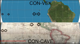
Reality, is a physically navigable thing. Do you not find it odd that there is no phsycial navigational proof for "flat earth" other than airplane routes? Do you not find it odd that literally, the only form of navigation to work with the AE projection is Flight? Occam's razor always applies. There is a reason the apparent horizon is always rising to eye level. Flat things don't rise physically or mechanically.