Lost New Orleans

Frostychud

Core Member
Active Member
Joined
Nov 17, 2021
Messages
306
Reaction score
1,930
PART ONE: INTRODUCTION

Some of the most interesting posts here are the deep dives on specific cities and buildings. New Orleans, Louisiana is a very special place and deserves to be examined, so I would like to start a thread about it, which I have divided into five parts as I have unearthed a lot of surprising information.

First, the official story. Louisiana was supposedly first explored in the late 17th century by Le Moyne, Sieur d'Iberville. Okay, we're one sentence in and we've already been lied to. Columbus found Cuba in 1492 but it took them two hundred years to follow the coast a few hundred miles north? My theory is that by starting the story off with a bald-faced whopper like this the mind is flash-hypnotized and primed to accept anything. The genius hypnotist Milton Erickson used to do this. When he met people he would just grab their arm unexpectedly to paralyze the conscious mind, utter a command, and presto, instant hypnotic induction.

New Orleans was supposedly officially founded in 1718. Louis XIV had died in 1715 and France was being ruled by his nephew and son-in-law, the Duke of Orleans. The kingdom was broke (supposedly because Versailles cost so much to build) so he and the "Scottish" banker John Law (made Controller General of Finances by Orleans) hatched a plan. Let me add in passing that Law is an important historical character who is credited with inventing paper money in its modern form.
engraving-John-Law.jpg
Years ago I dove deep on Law and remember reading a paper somewhere making the case that he was actually a Sephardic crypto-Jew. Sorry, I've lost the reference. In any case he is spooky as hell. Let me add that I am still not sure that any of these people really existed. The story goes that Law and Orleans decided to sell shares in a colonial enterprise in Louisiana. This was the East India Company M.O. and the suckers bit on it every time the scammers rolled it out. They still do. Law and Orleans put posters up all over Paris showing friendly Indians presenting settlers with platters of gold and diamonds in front of a mountain. I have tried to find a copy of this poster but have only succeeded in finding descriptions of it. The "Mississippi Company" ad campaign is considered to be the very first example of modern marketing (hypnosis) on record. The suckers of Paris lined up to give Law and Orleans their gold in exchange for paper shares in the company. The only problem is that it was all a complete lie. There are no mountains in Louisiana. It's completely flat. There is no gold. There are no minerals. What there was in Louisiana was alligators, snakes, yellow fever, and Indians (and maybe a few ruined cities, more below). The weather in New Orleans is tropical for half the year. It's very hot and humid and swampy and unhealthy. Law and Orleans knew this because they had received reports from Iberville and other settlers.

Mississippi Company - Wikipedia

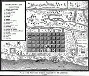
To keep the con going, Law and Orleans had to maintain plausible deniability. They filled a few ships up with hookers and convicts and sent them to the mouth of the Mississippi, where the local Indians had pointed out a propitious site for a city. New Orleans is still called the "Crescent City" because it sits in the middle of a huge round crescent bend in the river a few miles upstream from the mouth. A few miles to the north is Lake Pontchartrain. Pay attention to the grid right above the I in "River". That's the French Quarter, supposedly the historical kernel of the city. We will come back to that.
NewOrleansStreetRailwaysJan1904.jpg
Before continuing with the official history of the city, I would like to make a brief digression about the site. In another thread, I bring up the theory of a Russian blogger named Yyprst that there are certain geoactive sites on Earth from which energy radiates upwards. He suggests that large river bends curve around such sites. Well, New Orleans fits the bill perfectly. There is another very unusual detail here. In Grid of the Gods, Dr. Joseph Farrell argues that the power nodes on the surface of the Earth follow a certain geometry. Now, it so happens that both the latitude and longitude of New Orleans line up exactly, and I mean exactly, with two of the most important ancient sites Farrell discusses. The first is the Giza pyramid complex. Look at Google Earth. The latitude line upon which the Great Pyramid is situated cuts straight through the center of New Orleans. Let me say right away that I am highly skeptical of anything pyramid-related. It looks to me like they were built in the early 17th century. However, that doesn't mean that they aren't "real" in the sense that they don't have a real energetic function. I don't buy the hypothesis that they were just built to fake people out. The second site that lines up with New Orleans is the Tikal temple complex in Guatemala. Here the match is not quite so perfect, with the longitude line hitting about five miles to the east of the city, in the Gulf of Mexico. Still, this is startling and suggests the possibility that New Orleans is situated on a very active and important site on the Earth's surface. New Orleans has the reputation of being a "magical" place and I can confirm that there is something very unusual about the energy there, although of course this is a purely subjective datum.

Wikipedia gives us this artist's rendition of pre-colonial New Orleans with no source. We have an earth mound with a rudimentary ball pasmoid generator temple on top. After checking, I see this is actually a site in Alabama.
Taskigi_Mound_Aerial_HRoe_2020.jpg
Back to Law and Orleans. In 1720, the suckers in France finally catch on to the con. The value of their shares drops from 10,000 pounds to 500 pounds and the crypto-Jew Law flees France with a bag full of ca$h. He dies in Venice.

Everyone involved with the founding of New Orleans appears to be a spook. The Count of Pontchartrain, after whom the huge lake that forms the northern boundary of New Orleans is named, was the Navy Minister under Louis XIV and director of the East India Company from 1690 to 1693. He died in 1727 so was around for this episode.

If these people are even real.

Louis Phélypeaux was born on 29 March 1643 as son of Louis I Phélypeaux de Pontchartrain, and became an advisor to the Parliament of Paris by request on 11 September 1660. On 16 June 1677, he bought the post of First President of the Parliament of Brittany. (...) On 25 April 1687, he was recalled to Paris at request of king Louis XIV to become Controller-General of Finances, which began his career as minister. (...) From 6 November 1690 to 2 July 1714, Louis became Secretary of State of the Maison du Roi (Chief of the King's Household), and from 6 November 1690 to 5 September 1699 became Secretary of State of the Navy. From 13 November 1690 to 27 December 1693, Louis became Perpetual Head, President, and Director of the East India Company. (...) Phélypeaux served as Chancellor of France from 5 September 1699 to 1 July 1714.

So...this guy is big time. I notice some spookery in the numbers. Why do they include all these dates that no one cares about if not to signal stuff? Otto Didactic at Its-All-Fake claims that for spook signaling purposes, the number 1 can be read as whatever other numbers are next to it. The big spook numbers are of course 33, 77, 13 (33), 47, and 666 as well as any doubled or tripled numbers. Nine and six are interchangeable. So September 11, 1660, becomes 9/11/1660, which becomes 666666. Next we have June 16, 1677, which becomes 6/16/1677 or 666677 (or 666 77 if we write the date as 6/16/77). Finally we have November 6, 1690, which becomes 6/11/1690 or again 666666. Of course you have some other dates in there that seem to have no numerology attached. Maybe this is all delirium but I have seen enough evidence that spooks really do use these codes (the 33-saturated corona rollout being the most obvious), so who knows. In any case, we know this guy is a spook anyway because he was the head of the East India Company.

Short version: New Orleans was founded by a crypto-Jewish con artist banker (Law), the former Navy Minister and head of the East India Company (Pontchartrain), and the Duke of Orleans, who in addition to being regent of France also happened to be "Grandmaster of the Ordre du Temple", in other words, the head of the Templars. You could not find a spookier group of conspirators.

Back to the story. What's left after the bubble bursts in 1720 is a small little fortified town measuring six by eleven blocks, built next to the river.

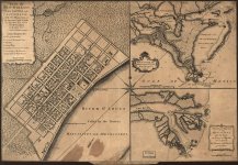
Here’s a map from 1718-20, marked 1728 and only published in 1753. What's the real date? Who knows. We see five horizontal blocks by nine vertical blocks. There is a building called “Government” that is separated from the city to the left. It does not appear on later maps. I think I know what this building is, and we will come back to it in Part Four.
1728Map.gif
Here's a map from 1720 with four horizontal blocks and eleven horizontal blocks, published for some reason in 1759 in London. Somehow we lost a horizontal block while gaining two vertical blocks.
1W-LA-NO-1720__07317__55590.jpg
Next is 1728. Dedicated to the India Company. Now the city measures six by eleven blocks and has a fort.
5436720_orig.jpg
Here’s a map dated 1731. But it’s missing two horizontal blocks. I guess it's older.
view.jpeg
Let's jump to the city in 1798 now:
vintage-map-of-new-orleans-louisiana-1798-cartographyassociates.jpg
The fort is different here and we picked up a few blocks, but it's still basically the same. The "Government" building is also gone. This "original" fortified village is today the French Quarter, where tourists go to drink Hurricane cocktails, barf in the gutter, and get robbed. I suspect that most of the French Quarter, now considered the historical heart of the city, was indeed built when they say it was. The buildings here are almost all old two- or three-story brick or wooden colonial buildings with galleries. It's very charming and picturesque. I say “almost” because there are at least two buildings in the French Quarter that strike me as possible salvage jobs, one of which might be the “Government” building that disappears after the first map. I will get to that. But first I want to point out something unusual. In senenty years the city doesn't grow at all. That's strange and now strikes me as a possible continuity error in a fabricated story. In that time Louisiana passes From French to Spanish control (in 1762), suffers two Great Fires (in 1788 and 1794), then passes back to France under Napoleon (in 1800), who turns around and sells it to Jefferson (in 1803).

Let’s look at the fires. The first one occurred on Good Friday, March 21 (3/21 which can be reduced to 33 or 322) at 1:30 PM (13 or 33), at 619 Chartres St. (666) and destroyed 1100 buildings (11). "Because the fire started on Good Friday, priests refused to allow church bells to be rung as a fire alarm." I can't believe I used to swallow stuff like this. What a joke. I guess this is just gratuitous mockery of Christians. At the Wikipedia entry we also get an overly dramatic description of the fire that sounds like fiction.

Great New Orleans Fire (1788) - Wikipedia

When you go to the Wikipedia entry for the 1794 fire, they tell us that the 1788 fire took place on March 12, not March 21. Busted. The date is made up, all that matters is that it adds up to 33/322. 12, 21, same difference. Also, the number of buildings that burned down is not the same in the two entries. Either this is a basic continuity mistake or the spooks are mocking us. I vote for the latter. I’ll be curious to see if it gets fixed soon.

Compare the following passages. First, from the 1794 fire entry:

The fire started on December 8, 1794, and stretched across 212 buildings, including the royal jail, though it stopped short of the riverfront buildings facing the Mississippi River. Among the buildings spared were the Customs House, the tobacco warehouses, the Governor's Building, the Royal Hospital, and the Ursulines Convent.

Now, the 1788 fire entry:

The fire area stretched between Dauphine Street and the Mississippi River and between Conti Street in the south and St. Philip Street in the north. It spared the riverfront buildings including the Customs House, the tobacco warehouses, the Governor's Building, the Royal Hospital, and the Ursuline Convent.

Busted again. The same five buildings in the same order were spared each time. The 1794 fire is just a fake copy of the also fake 1788 fire. I love catching the scriptwriters getting lazy and messing up the continuity.

Like San Francisco, New Orleans then has a suspicious “boom” period. From Atlas Obscura:

In 1803, when the United States bought New Orleans, along with the rest of the land in the Louisiana Purchase, the city had only about 8,000 people living in it. Planned on a tight grid, the city stretched just eleven blocks along a curve of the Mississippi River and six blocks back from the levee, to Rampart Street.

A little more than three decades later, New Orleans had become a world port, and in 1836 edged out New York City as the busiest export center in the United States. The population had grown to more than 60,000 people—many of them Anglo-Americans who, to the alarm of the city’s Francophone natives, had flocked to the port to make their fortunes.


For 15 Years, New Orleans Was Divided Into Three Separate Cities

That was fast. From a few shacks to a port bigger than New York in...how many years was that? Oh yeah, thirty-three.

The population of New Orleans doubled in the 1830’s and by the 1840’s the population was approximately 350,000, almost half of which were people of color or slaves, making it the fourth largest city in the United States at the time.

New Orleans's Golden Age

I would like to pause here and shift gears. Over the course of the next few posts, I will examine the classic “Stolen History” hypothesis, namely that all this is a coverup for the fact that New Orleans is a rehabilitated remnant city. When I first encountered the hypothesis that the New World had actually been recolonized with cities empty but more or less intact after either a natural catastrophe or a war using some kind of energy weapons (in my opinion the latter hypothesis is more probable), I immediately checked out New Orleans, but after looking at old maps and drawings, I told myself that the idea was crazy and forgot about it. Now I think it's possible that I just got my ass fooled by a handful of fake maps that could have all been fabricated in about a week and retroactively inserted into the archives, so I am revisiting the New Orleans file with more experience as a "researcher" under my belt, even if I do not feel worthy of that title yet.

If the Stolen History hypothesis is true, we ought to find out that the history of New Orleans was fudged, if not fabricated, to fit the recognizable buildings that we see in the first photographs from the 1850's. In other words, they started with the real city and retroactively created or modified a series of maps and photographs that would explain how the city went from being a little fort to one of the biggest and richest cities in the United States, complete with monumental architecture, in just thirty years.

The first obvious possible reset date is 1803, when the US took control of Louisiana. Here once again we have one of those magic dates right around 1800 in which "everything changed" because of Napoleon. The second obvious one is 1815, the date of the Battle of New Orleans, said to be the final battle of the War of 1812. You could probably ask a hundred educated New Orleanians to explain the Battle of New Orleans and the War of 1812 and no one would be able to tell you anything beyond “Andrew Jackson”. This war is some kind of black hole. I have no cognitive mapping for it whatsoever. Right off the bat at Wikipedia we get spook signaling. The battle took place on January 8, 1815. That’s 1/8, aces and eights, fake event code according to Miles Mathis. Remember, Moscow got nuked with some kind of DEW in 1812. Supposedly the Battle of New Orleans was more like a little skirmish that took place five miles outside of the city. Is this a cover story? Was the Battle of New Orleans bigger than we are told? Was New Orleans an important city that was also nuked in 1815 and then rebuilt? Were the French, British, Americans, etc. just squabbling over the postwar partitioning of New Orleans after they had collectively eliminated the “Tartarians”, a word which I simply use as shorthand for “whoever was there first and lost the war”? Kind of like Berlin in 1945, with French, American, British, and Soviet sectors? Were the “Creoles” the descendants of the original people who lived there? In New Orleans, “Creole” historically functioned as a catch-all term for anyone of any color with mixed non-Anglo heritage, with every possible variation of Black, Indian, French, Spanish, etc. present in the city. Still today one can find a lot of “light-skinned blacks” with blue or green eyes and “Indian” features, all on the French Quarter side of town. Some of them even still speak French (not many). I put “black” and “Indian” in quotation marks because I am not sure they are accurate terms. The Anglo-Americans were known for imposing strict racial segregation once they took over in 1803. It is almost as if one of their first jobs was organizing the mixed-race people they found there into fabricated categories based entirely on skin color and pitting them against each other: divide et impera. In other words, perhaps the multiracial Creoles were remnants of the previous civilization, and only later were they separated out into artificial racial groups and given new collective identities. As I once heard an older light-skinned black man joke on a bus, “Ain’t nothin pure come out of Louisiana”. The existence of the Mardi Gras Indian culture might also be an artifact of this original (botched) triage:

Mardi Gras Indians (also known as Black Masking Indians) are black carnival revelers in New Orleans, Louisiana, who dress up for Mardi Gras in suits influenced by Native American ceremonial apparel. Collectively, their organizations are called "tribes". There are about 38 tribes which range in size from half a dozen to several dozen members. (...) Mardi Gras Indians have been practicing their traditions in New Orleans at least since the mid-19th century, possibly before. The history of the Mardi Gras Indians is shrouded in mystery and folklore.

Mardi Gras Indians - Wikipedia
5d275cca7113e.image.jpg

This is not some kitsch costume thing. These people trace their history back to the Indians and take it seriously.

This is just an introduction. In Part Two we will begin to look at some old photos and hard evidence for an architectural coverup.

ADDED: I found a few very unusual Dutch caricatural engravings of John Law and his financial shenanigans. They have that "Roman"/pagan/Piranesi/"world before" look. I can't read them, but maybe someone else can. Perhaps there's something interesting here:
mississippi-bubble-1720-granger.jpg
iam-wha-100-0015.jpg
iam-wha-062-0760.jpg
hez-2707295.jpg
 

Attachments

  • 30th latitude.jpeg
    30th latitude.jpeg
    28.4 KB · Views: 661
  • 1728Map.gif
    1728Map.gif
    121 KB · Views: 326
  • 1W-LA-NO-1720__07317__55590.jpg
    1W-LA-NO-1720__07317__55590.jpg
    342.4 KB · Views: 344
Last edited:
PART TWO: CANAL STREET AND THE ST. CHARLES HOTEL

The biggest and widest street in New Orleans today is called Canal Street. It separated the French Quarter from the so-called "American Sector", so named because it was here that the "Americans" began to build and settle after 1803. Canal Street is what divides New Orleans into Downtown and Uptown, with the two halves of the city still having very different flavors. The Canal Street median is still referred to as the "neutral ground" because it functioned as a DMZ between the French Quarter and the American Sector during the tense years following the American takeover, in which the city was flooded with uptight Anglo immigrants who all settled on the other side of Canal Street from the original Franco-Spanish-Black “Creole” colonial city.

Canal Street is so-called because there was originally supposed to be a canal there that was never built. Hmmm. Otto Didactic, whose website has largely inspired me to write up this report, advances the idea that cities of the Olde World were canal-based, like Venice today. In particular he believes the avenues of Paris were originally canals and Paris was a big Venice. I find the idea highly convincing. It would explain where the subway tunnels come from. The old canals, possibly carved out with some kind of directed energy, had simply been culverted over at some point in the past. Presto, underground tunnel system with no new digging necessary. The story of the excavation of the Paris metro is another of those impossible stories that make you realize that we are really being lied to. The first subway line opened as part of the 1900 Paris World's Fair. Within ten years they had dug out something like a hundred miles of intersecting tunnels under one of the biggest cities in the world with primitive equipment. Yeah...maybe. It makes more sense that they were just fixing up the tunnels and sticking new trains down there. I also now think that the equally impossible Haussmann renovation of the mid-19th century was actually the government (rightfully) knocking down all the cheap shanties that had been built over the old buried canal/tunnel system by recent Industrial Revolution arrivals. Haussmann knew the old infrastructure was there and just saved it from being irretrievably covered up before it was too late. It would also explain why the avenues are so wide.

The Iconic Avenues of Paris are Ancient Canals

(Side idea. If Otto Didactic is correct and old world cities had canals instead of streets, is it possible that the vehicles were not boats but rather some kind of floating antigravity airships that hovered over water and only water? Was Paris Atlantis?)

Was Canal Street an actual canal in pre-Reset New Orleans? Here are a couple of photos of Canal Street throughout history:

1857:
canalstreet1.jpg
1858-1860:
057e482141627298d971360e115529cb.jpg
Little later:
2009670.jpg
Turn of the century:
service-pnp-cph-3a00000-3a00000-3a00100-3a00154r.jpg
1940:
view-of-canal-street-new-orleans-1940-MM2D59.jpg
Check out the following short article on Canal Street to get a feel for the narrative, written by Edward Branley, the "Nola History Guy" (more on him later).

NOLA History: Antebellum Canal Street - GoNOLA.com

Here's a bird’s-eye map of New Orleans established in 1850:
Image 1 (Bachmann).jpg
Canal Street is the wide street in the middle-right that leads to the river. The big building at its base is the Custom House and it is very important. We will hit that one last. The rightmost big building with the spire is St. Louis Cathedral, located at the heart of the French Quarter.

Here's a view from the American Sector looking towards Canal Street (perpendicular) and the French Quarter published in 1852:
New_Orleans_lithograph_from_1852 (1).jpg
We'll come back to these and try to pick them apart. For now let's move on to the first building that makes no sense, the St. Charles Hotel. It's the big domed hotel just off Canal Street, right in the center of the first map and just left of center on the second. Look closely at the dome. It’s different in the two views published only a year apart. The St. Charles Hotel was supposedly built in 1837 by James Gallier, an architect from Ireland who ended up in New Orleans and is credited with designing several of the most iconic structures in the American Sector, including the "Greek Temple" Gallier Hall which is still standing. More on him later too. But the St. Charles is really unbelievable. Check it out:

St. Charles Hotel, New Orleans - Wikipedia
Gaston_Pontalba_1848_St_Charles_Hotel_New_Orleans.jpg
images (20).jpeg
images (16).jpeg
images (18).jpeg
This photo looks fake to me. The dome and the columns don't line up quite right. The perspective is wonky.

It supposedly had the second-biggest dome in the United States after the US Capitol (!). This thing was 185 feet tall. Thirty years before it was built, New Orleans was a just a few wooden houses, and now we have this?
Screenshot_20230801_101149.jpg
It was...wait for it...destroyed by fire on January 18, 1851. Check the date: that's 1/18, aces and eights, spook code for a fake event, just like the Battle of New Orleans. We get a painting of the fire:
images (17).jpeg
The dome is still there on the 1852 map above. The building burned at the very beginning of 1851. You’d think a year would be enough time to fix the map before publication, but maybe not.

We have multiple different domes if we look at the drawings. We have a dome with no columns in the 1850 bird’s-eye map above if you look closely. I don't know what that means. Was this place even real? Was it fixed up? Did it only exist on paper? Also, to my knowledge, 1850 is too early for photography in New Orleans, yet that photo was supposedly taken before January 18, 1851.

The spectacular fire which took the first St. Charles Hotel in 1851, also, destroyed the First Methodist Church, First Presbyterian Church and 15 other buildings. There were some injuries, but amazingly, no fatalities. This seems remarkable when you consider that the hotel had over 800 guests in residence at the time of the fire.

NO_StCharlesHotel

So we have 18 total buildings and 800 guests. On 1/18. More aces and eights. No fatalities? Is this a joke?

The hotel was rebuilt in 1853. That was fast. The second version of the hotel looks identical to the first, only there is no dome:
download (13).jpeg
Crescent_City_illus_from_CresCityLimtd_1873_6_e_-491x528.jpg
Again, I don't know what to make of this. It looks like they just cropped the dome out of the photos and called it a second hotel. Or, more likely, they just added a dome to the other photo. Why? Does anyone recognize the dome from somewhere else? This hotel supposedly stood until 1894. Here is a photo from the late 1850's in which you can see the domeless top of the second St. Charles Hotel peeking from behind the buildings on Canal Street. This photo looks real to me:
Jay_Dearborn_Edwards_500_block_Canal_St_1859 (1).jpg
It gets more complicated. Here's a view of New Orleans under Union occupation, 1862, published in 1866:
ECWC TOPIC New Orleans PIC The Fleet at Anchor Frank Leslies Illustrated Newspaper.jpg
Eleven years after burning down, the first St. Charles Hotel is back, baby, only now there is a flat dome and no columns. Continuity error.

There was of course a THIRD St. Charles Hotel that was built after the second one also burned down. Here we have a modified-looking photo from the exact same damn angle. This thing at least was definitely real as it was there until the 1970's.
images (21).jpeg

Let's move on to our second grand hotel, called the Verandah, catty corner from the St. Charles. This one also burned down. The origin story of this hotel is laughably fake:

Verandah-Hotel-from-LSM-courtesy-Scully-James-Dakin-Architect-e1570049341697.jpg

The fiery birth and demise of the Verandah Hotel

When toasts were made, some men saluted their native countries, which incited others to do the same, with increasing alacrity and mounting retort. “Gentlemen, I give you my native land, England, with all thy faults, I love thee still,” crooned one guest, to which responded an Irishman, “Damned if I do!” The amity of the evening turned to enmity, and in this time and place, such affronts to pride and honor could lead to bloodshed. Instead, they led to a commercial challenge, as English-born Richard Owen Pritchard, incensed at the Irish investors, shouted, “Damn your hotel! I will build one of my own!” We know of this disastrous dinner from the recollections of one of the guests, which appeared in an 1876 newspaper article and which Scully deemed to be generally credible, if a bit colored.

All I can say is LOL. So this is what propaganda looked like in 1876. You can see how people were programmed to react to certain things in certain ways. The psychology here is schematic and unsophisticated. The Verandah supposedly burned down on July 19, 1855. No numerology that I recognize. The author, Rich Campanella, is a popular local historian we will see more of.

I am running out of photo attachments, so we'll wait until the next post for the third grand hotel. It only gets more confusing.
 
Last edited:
My sister in law just went to New Orleans, and it was sad to hear that everywhere she turned there was puke in the streets and some drunk idiot(s) around. Sounds like a blast, not!!!

I just wanted to let you know if you didn't all ready that there is a history of all the beautiful cast iron that you see in New Orleans. The information finds that these shapes that are of cast iron actually are symbols with meaning to the artists that made them.
 
Mind blowing research my man! I've always been attracted to Nola and I currently live a little over an hour away from there as I'm in the Mississippi Gulf Coast for at least a year working. Interesting find on the map showing how the Mississippi is also referred to as the Meshassepi which has a very Semitic sound to it as do many Native names but that'll be another story for another day. Essentially I agree New Orleans, which is part of the real Fertile Crescent as it's name literally was Crescent City (not the barren sandpit in the Middle East...Old World Florida does some good research on this) being a major Tartar/Mongol/Native hub and likely always had some sort of French/Latin presence. Interestingly, the native Choctaws called New Orleans Bulbancha which literally means "the place of many tongues."

Part of what I'm trying to piece together with our hidden American history is the war between the Germanic Holy Roman Empire (with allies from Spain and some pro-Reformation Italians) and the Vatican during this period which was evident with the 1527 Sack of Rome where the forces of Habsburg Charles V of the HRE defeated the forces of the Medici Pope Clement VII of the Vatican (so the story goes). Funny enough, Rome was supposedly sacked by Germanic Scythian Barbarians such as Visigoths and Vandals 1000 years earlier (and then 1000 years later they rediscover their toga-wearing past and want to replicate that civilization...just like how I want to replicate horse and buggy life in the 1800s because I discovered it in some photographs). Then there is the obvious connection with the Vatican and the Spanish monarchy (who were also Habsurgs) defeating the Moors and making their way to the Americas in 1492 with the Columbus story the same year Church defeated the Moors in the Battle of Grenada. To me, we're either looking at dividing the spoils of war between powerful families such as the Habsurgs and Medicis (who might also be front families for something far more sinister than even them) or factional infighting among these families which leads to all of these strange alliances and battles they have with and against each other (just like how we supposedly are friendly with Russia in Syria years ago and now we want to help Ukraine destroy them...Orwell in 1984 sums this up with we were always at war with Oceania...we were always allies with Oceania)! And Pope Clement VII apparently absolved Charles V for the attack when Charles said he didn't order the attack. Strange. Furthermore, the English were said to have been allies with the Vatican in the League of Cognac with the French and Venetians and after Charles V assumed power over the Vatican he denied the annulment of the marriage between his aunt Catherine of Aragon from Spain and Henry VIII of England and this famous story supposedly shifted England from the Vatican to their own English Reformation and eventual Anglican Church. Definitely a power struggle with the Vatican on both the Americas and the other side of the world.

Back to Nola, yea I agree I can't buy that story that no Europeans had come to this major Native trading part just a few hundred miles from the Caribbean and Florida panhandle between 1492 and 1690! I'm going to focus a lot on Nola in the research I'm doing trying to make sense of the Holy Roman Empire and Vatican feuds along with the Tartar/Mongol/Moor natives and Islam as a big part of piecing together our hidden history. Also, if you or anyone have any specific places in Nola or the surrounding area you want photographs of just let me know I'm in the area frequently and will do it next time I'm there which will be in the next couple of weeks. I got inspired after listening to Exhibit B by Jay Electronica and Mos Def after reading this. Jay Electronica is a Nola emcee and his second verse on that song is one of the greatest in hip-hop history as he rhymes about recovering from Hurricane Katrina. He also dated Kate Rothschild, a music mogul from the infamous family, which is also interesting.
 
PART THREE: THE ST LOUIS HOTEL

Our third grand hotel is the St. Louis. This one supposedly burned down in 1841 and was rebuilt identically. It functioned as the Louisiana State House for eight years between 1874 and 1882, then fell into disrepair and was finally torn down in 1917. This one is in the French Quarter and might be the grandest of the three.

king037.jpg
download (14).jpeg
download (19).jpeg
This last photo is the one that keeps me up at night. It looks fake, like the dome has been photoshopped in. There's something wrong with the depth. It's too flat. I see three superimposed two-dimensional layers. I guess getting the angle and perspective right when adding a dome to a cube are tough. Is the goal to make us believe there is some evidence that the "hotel" ever existed in a functioning state? Or that the dome ever had a roof? Someone took the trouble of creating this pasteup. Why? Does anyone recognize the dome from an Italian church somewhere?

I think this is a REAL photo of the dilapidated "hotel":
download (17).jpeg
download (16).jpeg
download (15).jpeg
I think the last one is a real but manipulated photo of the ruins being demolished, supposedly in 1917. Meaning: they only real photos we have are of a dilapidated, found structure. There are a lot of photos of this hotel, but they all show it messed up even though there ought to be plenty of photos of the place looking good considering it was used as the State House until 1882. All we have are drawings.
b43e86086dc51daa32b3201236c8c848.jpg
I_2_041_041.jpg
Here is the inside of the dilapidated rotunda. Problem one: the floor is way too high, right under the dome. Problem two: the clock and chandelier are bad early photoshops. But again, why? Also, the rotunda does not resemble the rotunda in the original engraving at all. That one has big arched doors. Did they just find an old dilapidated structure with a big rotunda and invent a fake "hotel" backstory before tearing it down? Was this the headquarters of the Resetters at some point?

The Old St. Louis Hotel

Richard Campanella explains, “auctions of every conceivable form of property, including enslaved human beings, were conducted beneath the 88-foot-high dome surrounded by towering Tuscan columns, like a scene out of ancient times” [1].

And then we get this photo with the two Masonic columns, supposedly the old slave auction block:
download (18).jpeg
We know it's a slave auction block because they're nice enough to give us a slave:
unnamed.jpg
Campanella again. Is this guy mocking us? 88 feet high, double eights again, with a 1 footnote after it for the ace? "Like a scene out of ancient times?" Richard Campanella is a popular contemporary historian of New Orleans who works at Tulane. He wrote a whole book about Lincoln's brief visit to New Orleans. I am not convinced Lincoln existed. Is this guy another spook? Am I just paranoid? The only obviously spooky detail I see on his CV is a stint in the Peace Corps, which I am pretty sure is an Intel operation…

Campanella is heavily promoted in New Orleans. In another article about the streets reclaimed from the river frontage past Levee/Decatur Street (more about that in Part Four), he writes the following:

All these American-named arteries had a singular geography: They would occupy the sandy beach that began forming naturally along the riverfront…starting in 1807, four years after the Louisiana Purchase. Creoles called it the “batture” and enjoyed promenading on it or carting away its sand for fill. It was all perfectly legal, because in their minds, Louisiana’s Roman civil law tradition viewed such ephemeral ‘terre d’alluvion’ as a public resource. The American legal perspective saw things differently. English common law regarded such riparian areas as belonging to whoever owned the adjacent land. Accordingly, proprietors of abutting properties eagerly erected makeshift levees to bring “their” batture under control – to the outrage of the Creole population, which viewed such actions as the privatization of public space and the loss of a cherished right.

The story of Front Street: New Orleans' fragmented relic of the St. Mary Batture, and how it formed

Okay, I know this is thin evidence. But twice now we catch this guy making possible winking references to antiquity in New Orleans. Why does he say Roman and not French or Napoleonic? (Louisiana is the only state to use the Napoleonic Code as the basis for its civil code.) And why does a sandy beach suddenly start forming four years after the Louisiana Purchase? Was New Orleans a full-fledged SPQ city that was stripped of its rights after being destroyed in the “Napoleonic” wars? Here we again also see the “Creoles” as heirs of a very different type of society than the Anglo one.

(We will come back to these mystery blocks added to the city in Part Five.)

Another local historian with a lot of articles on the net is the "Nola History Guy", Edward Branley, whom we have already caught feeding us aces and eights with the fake St. Charles Hotel. Here he is displaying the "thinking man" spook gesture. (Joseph Farrell does this too.) He does it in multiple author photos.
download (20).jpeg
Screenshot_20230731_191500.jpg
He mocks us too. In his article about the St. Charles Hotel I linked to in Part Two, he writes:

Oakey Hall, who later became the mayor of New York, said of it, 'Set the St. Charles down in St. Petersburg, and you would think it a palace; in Boston, you would christen it a college; in London, it would remind you of an exchange; in New Orleans, it is all three.'

I think he's telling us to our faces that these buildings were found and their functions later fabricated depending on which fake story was being pushed.

Can we catch Campanella throwing up gang signs too? Here's his official Tulane photo, hands hidden in pockets. Do you do that for portraits? I don't.
Campanella.jpg
Try the one-knee pose. I just did. It feels unnatural to me. I would squat. Maybe that's just me. Unfortunately the name on the grave is illegible.
campanella (1).jpg
It makes me think of the creepy 8-minute masked Masonic kneeling ritual the Democrats engaged in during the George Floyd psy-op:
01-Nancy-Pelosi-Fashion-Diplomacy-gq-june-2020.jpg
Something tells me Nancy Pelosi's choice of Freemason Orange for this ritual (even the shoes) is not a coincidence.
Richard_Campanella.jpg
Campanella also sports orange here. I think holding your wrist like that is significant. Inconclusive. However, when we take into account the fact that he is also right in between two columns...I start to get suspicious. Upon even closer inspection, I believe he has been pasted into that background. He kind of float-sits. The hat looks added on, maybe to make it easier to blend with the background. Or maybe because it has some occult signification. No shadow under the brim, busted. He's wearing it in all three photos. He is also lit differently than the background. They had to get him right between Jachin and Boaz.

To be fair, I cherry-picked these three photos of Campanella. Most of the photos of him online are totally normal. That last one seems like a smoking gun, however. This research makes me doubt my sanity. So many of these photographs are obviously fake and there is absolutely no explanation for that. Fakery necessarily implies concrete fakers. Someone added that chandelier and clock. There really were rooms full of people somewhere cutting up negatives, pasting them together, and passing the fake images off as real. They really were following orders given to them by superiors who had a larger deceptive aim in mind. The universality of the practice implies an organized central command structure. This is something very solid we hold in our hands here and we cannot forget that.

But then when I start reading what mainstream historians write, they clearly have at their fingertips a complete command of the documentary evidence. Campanella appears to have studied every extant map of the city since its founding and gives the impression of knowing the exact history of every single block, street, building, everything. He drops references offhand to the 1815 Tanesse map, the 1833 Zimpel map, etc. When I look at these maps, especially those after 1815, they look pretty damn convincing. I mean, at some point the history becomes real after all. Campanella and company seem rational, intelligent, and passionate about history. I imagine them reading what I write here and pitying me for being so deluded. After all, these people have spent their lives studying this stuff, and I am just working from typos on Wikipedia. At these moments I feel like a complete paranoid idiot talking about Directed Energy Weapons and secret forgery societies. "Look! He's kneeling in a photo! PROOF NEW ORLEANS WAS NUKED FROM AN AIRSHIP IN 1815!"

But then when I think harder I change my mind again. I lived through Covid. I witnessed in real time a completely fake narrative being rolled out and salted in with mountains of garbage documentary "evidence" produced by drone-class spooks. No one will doubt anything in twenty years. I’ve read Kammeier’s Falsification of German History. He picks the documents apart and shows that yes, there is a universal forgery operation going on here, yes, it is extensive, yes, they are clever and wicked, yes, there is a secret central planning committee, yes, they have come up with lots of tricks to confuse the hell out of you. I try to imagine myself as one of the hoaxers. I think about someone like JRR Tolkien, who created an entire fantasy universe complete with maps, psychologically convincing characters, and genealogies, and that was just one guy. What could a hundred well-funded people working full-time on such a project achieve in a lifetime? A thousand? I think about how complex and ingenious the plot of “The Wire” is, and it was written by just a few people sitting around a writers room part-time for a few years. Not only that, they actually filmed their stories. Even more impressive, they did not know where they were going with the story when they began, yet were somehow able to make the whole arc of the show seem inevitable. The only possible explanation is that they can always count on us, the viewers, to fill in the gaps with our own imagination without even realizing we are doing so, because that is the sad, enslaved nature of the human mind. We want to believe so badly that we will unconsciously take responsibility for all contradictions and inconsistencies in the stories we are told. When faced with the lies of our masters, our natural response is not anger but shame. They know this and they use it against us. When I start to think of it that way, it no longer seems impossible for a dedicated group of multi-generational history forgers to fill in a staggering amount of details and seed them everywhere. I can imagine that there was one guy who was the map guy for New Orleans and his sole job was to start backwards from a certain date and forge a convincing series of fakes showing the city growing. This would actually be relatively easy if there were no authentic maps that risked popping up. That means the operation would have had to begin before there were any other maps, or at least any mass-produced maps. I mean imagine that’s all you do, every day, make fake maps of just one city or region. On day one of the job you are given all the old maps of your city and simply instructed to study them and commit them to memory. By the time you’ve been there for a year you can probably crank out a flawless backdated fake map with any detail you want changed in a few days. A few times a year you meet with the map guys from other regions and compare notes. In the office next to yours is the color guy whose job is solely to invent anecdotes like the dumb story about the Englishman opening his own hotel or the priest refusing to ring the bell on Good Friday. There’s an editor whose job is to make sure everything fits together. It’s basically just like a newspaper office or a university department. Maybe Campanella’s job today is coming up with arcane old legal battles over levee soil and then seeding them into the archives. That’s exactly what I would do if I were a forger. I could imagine meeting with my associates once a week for wild brainstorming sessions over drinks. I can imagine congratulating myself on my cleverness as I come up with detail after convincing detail that no one would ever dream of doubting. Like an 1807 legal battle over batture soil, with aged-looking documentation supplied by the Art Department. There's a handwriting specialist there who can do every script from 1500 to 1900 in his sleep. Maybe that story got the whole team promoted from 24th to 25th degree Mason. I can also imagine how much fun it must be to drop little winking hints of antiquity in my fake stories. We'll see more of those in the next part. I can imagine individual agents trying to one-up each other in cleverness and sophistication like pro ballers practicing trick dunks. I can imagine the intoxicating feeling of triumph and power that must animate the whole enterprise once it becomes clear that it’s really working. I have a suspicion that hoaxing and forging are much, much easier than they seem from the outside. I guess it's fun, too. Like playing the piano, it looks like magic, but it’s really just something you can learn. I think the most important thing to remember is that if it’s on paper, it can be faked. As soon as you’re dealing with documents, you’re dealing with words, and as soon as you’re dealing with words, you’re dealing with magick spells. There is nothing easier for an intelligent person than to line letters and words up in such a way that people are cast into a hypnotic trance. Verisimilitude is cheap. In fact it is given for free by the hypnotized subject. Photos are a lot easier. Once you learn how to spot fake photos, they completely lose their hypnotic power. The forgers made a mistake by releasing all those tampered photos. It is much, much harder to spot fake stories, because in a certain sense, they are ALL fake, including the "true" ones. What I mean is that there is no such thing as a really existing story against which to compare a fake story. We can compare fake images to the real images we see with our eyes, but we cannot compare fake stories to real ones because there ARE no real ones. The very nature of the story is that it is an artificial construct made of magick letters. For this reason, I think examining photos and artifacts has a much greater chance of yielding results than wandering onto the terrain of narratives, where the hoaxers have complete control.

That said, I am not even sure if I believe what I am arguing here. I am simply approaching it as an exercise or an experiment, and seeing if anything sticks. I will say that more is sticking than I originally expected...

I will end this post by sharing a few words of wisdom from the legendary New Orleans rapper BG. In the dark and depressing song “He Used 2 Be a Man”, he sings the tale of a gangster going to prison and getting turned into a punk by “them big dogs”:


View: https://youtu.be/4vIqJCJ3dcg
(Looking at the thumbnail I see even BG is doing the thinking man.)

When you was on the street/you was a soldier/and then you got f*cked when you went to Angola

He ends the song with the following unforgettable observation about how sodomy really goes down in prison: Niggas be getting talked out of they ass. Niggas not even getting raped, they getting talked out of they ass. Nigga, that’s cold. In other words, when some spook historian is trying to hypnotize you with reassuring stories in order to metaphorically f*** you in the a**, you should be paying attention to his hands going down to his fly (the tampered-with photos and artifacts), not to the hypnotic words coming out of his mouth (the seamless narrative propped up by documents).

In Part Four we will look at more buildings and meet more weird people.
 

Attachments

  • download (17).jpeg
    download (17).jpeg
    11.5 KB · Views: 211
  • unnamed.jpg
    unnamed.jpg
    375.3 KB · Views: 247
Last edited:
Keep dropping the knowledge brother! I’m thinking maybe the references to Roman because the French may be an extension of the Roman Empire in the grand scheme. Like I said I’m working on trying to piece together the European events to correspond with the American events so I’ll see if I can come up with anything. Keep thinking Napoleon selling Louisiana to the US after just receiving a good portion of the modern US ranging from the Dakotas to Louisiana after a “secret“ 3rd Treaty of San Ildefonso with Spain in exchange for Spain receiving territories in Tuscany. Maybe these elites just trade land and livestock human slaves like billionaire sports owners trade players. But something just doesn’t seem right about this story. France and Spain were said to be allies until the Illuminati/Jacobite French Revolution where King Louis XVI of the House of Bourbon was executed, essentially ending the French Monarchy. So now Spain, who still has a monarchy, is at odds with France under Masonic Illuminist Napoleon Bonaparte. Spain supposedly just had this large territory that they traded back to France from the 1763 Treaty of Paris where they French supposedly gave them all that land because Spain lost so much land to the British. Geez these people change sides more than pro wrestlers. As you highlighted with the redactors of history, Orwell emphasized the extent of the operation in 1984 stating that it was a continuous work. Supposedly Spain was struggling to stave off US expansion, which to me just means Holy Roman Empire/NWO/Masonic/Illuminist expansion or whatever you want to call it. Still convinced that there’s so much more to the HRE/Vatican split than what we know and WW2 was the climax of the finale of the conflict. Still trying to piece it all together.
 
PART FOUR: JAMES GALLIER, MORE SPOOKS, THE CUSTOM HOUSE

Let's check out a few more buildings and see what we find. Here is the Church of the Messiah, looking very old-world, also in the American Sector.
2009.0224.19_o3.jpg
The people are drawn in. I think that's a fake wall around the base as well, added, I suppose, to hide something. But what? Why are all these photos altered?

In 1893 the congregation, under the leadership of Pastor Walter C. Pierce, sold the church and moved uptown. Barnett's church was torn down shortly after the sale to make way for a garden planned by neighboring property owner Joseph Hedwig.

More mocking fiction.

We saw earlier that James Gallier was the most famous historical architect in New Orleans. Let's hit him now. We've seen before that a lot of these characters are fake. What about this one? He supposedly died on the Evening Star (that's Venus), a boat that sank in 1866 and which appears to be a precursor of the fake Titanic sinking. They really do just keep using the same hackneyed scripts.

On September 29, 1866, The Evening Star set sail from New York without incident at 3:30 p.m. with approximately 219 passengers and 59 crewmen. On October 1 she passed Cape Hatteras, off the North Carolina coast, enjoying calm weather. The following morning, a cold breeze from the east created a heavy swell, increasing to a gale by evening. It was soon evident that the steamship was in the middle of a hurricane 180 miles east of Georgia’s Tybee Island.

Loaded Down with Iniquity - 64 Parishes

3:30, right? 180 miles, right? October 1, right? The ship was supposedly loaded with prostitutes, opera singers, and circus performers as well as several VIP's. The story reads like bad allegorical fiction. This website appears to be another spook operation. The author, Sally Asher, has a website named SallyAsherArts. I see "Ashera" there. That's also Venus. She has a photo of herself posing with warlock Michael Obama on her site. I guess that's a big honor for a ground-level spook. I wonder what she did to deserve it.

Her work has appeared in many local, national and international media outlets, including, but not limited to Newsweek, U.S. World News, The New York Times, The Real Yellow Pages, the 2009 Academy Awards Green Room, the Gambit, Time, Penthouse Magazine, and New Orleans Magazine. (...) Asher is a member of the Arts Council of New Orleans, the Louisiana Historical Society and the New Orleans Photo Alliance. She has also delivered lectures for Friends of the Cabildo.

From Google Books:

Asher frequently lectures on New Orleans history through the Louisiana State Museum. [She is a] member of multiple Mardi Gras krewes.

So she's in a bunch of spook councils and occult elite clubs (Mardi Gras Krewes, more below) and is published in the usual spook rags.

Her Instagram account shows her...

...doing the hidden hand in front of Carrie Fisher's grave (is she some kind of top witch?):
Screenshot_20230803_154156.jpg

...gushing over the Knights of Pythias:
Screenshot_20230803_154254.jpg

...touring the gravesites of local 19th century Freemason spooks:
Screenshot_20230803_154804.jpg
Lots of creepy occult signaling everywhere. She wrote a kids' book about mermaids (occultism) in which the main character's initials are CC (=33).

Let’s ditch the witch and look at a couple more "Gallier" buildings. Here's the Church of Christ, supposedly built on Canal Street in 1837:
christ_episcopal_normans_1845.jpg
From Edward Branley's site.

From Neighborhoods Archives

By 1845, real estate developer and merchant Judah Touro set his sights on the 701 block of Canal Street. He acquired most of the property on the block. In 1845, Touro made the congregation the proverbial offer they couldn’t refuse. Christ Episcopal acquired the corner of Canal and Dauphine Streets, one block up from the existing church. By 1847, Touro completed the deal. Christ Episcopal moved up the street. Congregation Dispersed of Judah moved into the church building at Bourbon. They remained there until 1855. While Touro passed in 1854, the project continued. They moved Dispersed of Judah to a new schul uptown and demolished the Canal Street synagogue. By 1857, the entire block consisted of a row of four-story buildings.

So once again we have a grand old Greek "revival" building attributed to Gallier disappearing in that crucial 1850's sweet spot right around when photographs were starting to appear. They demolished it how many years after building it? 1837 to 1855 is…eighteen years, that stupid magic number again. At least here we have a somewhat plausible explanation: the Jewish real estate developer wanted to monetize the property by building apartments.

Actually, let's check the developer, Judah Touro, whose name is all over New Orleans. Born June 16, 1775 - that's 6/16 or 666 - died on January 18, 1854 - that's 1/18 or aces and eights. Did this guy even exist? Judah Touro, Jew Taurus? Is this guy some astrological allegory? His Wikipedia bio reads like it, with him being wounded in the thigh (a trope from antiquity, the "thigh wound" is actually castration) in the Battle of New Orleans and nursed back to health by someone named Rezin Davis Shepherd. According to Wikitree, Shepherd was born on August 1 (8/1) and died on November 10 (11/10) "at the age of 81" as they make sure to point out. This fake character is connected with Harper's Ferry and is a rabbit hole all of his own. Otto Didactic identifies Harper's Ferry as a pre-Reset town that was bombed to smithereens during the Civil War to cover up its antiquity.

When I Google Shepherd, I get this video:


View: https://youtu.be/YeHSlqiDUiU

The full title is Rezin Davis Shepherd and his 180-Year-Old Working Mechanical Tower.

So they use this guy too to explain a pre-Reset structure in West Virginia. In another video by the same guy, probably the spook assigned to the Shepherd file, he is described as a "money wizard". And of course there's the inevitable 180 in the title of this video. The videos have almost no views. More evidence that covering up the architectural remnants of the Reset is at the very heart of the deception.

The original Rezin was an Aramean king. From Wikipedia:

Rezin conspired with a number of Levantine kings (e.g., Hiram II of Tyre) to rebel against Tiglath-Pileser III.

Hiram of Tyre, Phoenicia...more Masonic coding.

So, two fictional money wizards, Shepherd and Touro. Touro = Age of Taurus, Shepherd = Age of Aries? Baal meets Jesus? The Lower Egypt Hyksos Pharaohs with their shepherd's crook and the Upper Egypt Theban Pharaohs with their ox flail? Do they pattern all their fake stories on the zodiac? The scriptwriters made the real estate developer a Jew because that's the role they've been assigned in the big theater play: they're the heels, you’re supposed to blame them. They even gave him the face of a cartoon villain:
images (23).jpeg
This unbelievable mocking photo was "recently found" by Albert Kaplan, whose spooky website is full of "rare" daguerrotypes of historical figures, with an equal mix of virulent antisemites/racists (Henry Ford, Charles Lindbergh, Richard Wagner, Custer) and Jews/"liberals" (Disraeli, Lincoln, etc.) Hegelian dialectic in action, promote both sides. This daguerrotype is in near-mint condition and "must have been kept in a vault." Yeah...in a vault. Before the miraculous discovery of this photo, we only got drawings of this guy.

Judah Touro #2 | The Kaplan Collection

This is all so f'ing creepy. These people are all fictional characters curated by spooks. I guess Kaplan's assignment is to "find" (forge) new photos that add more depth to old characters...ground-level world-building.

I have a sudden idea. I have puzzled over the origins of the Zodiac for a long time. It's one of the most confusing enigmas of history. What if the Zodiac is nothing but a scriptwriting cheat sheet and template? You can go to Los Angeles today and pay a thousand dollars to attend a screenwriting seminar in which a script doctor will reveal to you the conventions of Hollywood storytelling. He will even include diagrams and charts that look vaguely astrological. Protagonist, antagonist, love interest, exposition, rising action, conflict, climax, resolution. Think about it. The universal history forging operation would need precisely such a template to keep everyone on the same page. Why not invent a mnemonic system that can be checked simply by looking up? This would kill four birds with one stone.

- First, it makes it easier to write fake stories.
- Second, it also allows you to recognize which stories have been written by deceiver colleagues.
- Third, it provides religious cover.
- Fourth, it replaces the real science of astronomy that predated it, one based on tracking the heavens to access energy from the aether.

Is this why all civilizations around the world use the Zodiac? Because they were all written by the same losers? These poor spooks have no imagination, as that's something you lose when you sell your soul, so they have no choice but to keep churning out the same dumb, pretentious, pseudo-deep, pseudo-cosmic stories. The Sun that travels through the twelve houses encountering boring predictable peripeties is nothing but a stand-in for the scriptwriters themselves, or rather the script itself, the deception itself. That's why they want us to worship it.


I will perhaps develop this idea in another thread.

Back to our original fictional character, Gallier. Here's Gallier Hall, finished in 1850 and still standing. This was City Hall for about a hundred years.
images (24).jpeg
D-1850s-Gallier_Hall.jpg
At the Preservation Resource Committee of New Orleans website, we read the following:

The building is “the best surviving example of Greek Revival architecture in a city that once had more monumental Grecian specimens than ancient Athens in its prime, and an outstanding example nationally,” according to New Orleans Architecture Volume II, The American Sector, published by the Friends of the Cabildo.

Wait…what? New Orleans had more monumental Grecian specimens than ancient Athens in its prime!? We have photos of what…three of them, none of which are that impressive? Are the spooks once again mocking us? How many of these buildings do they know about that were destroyed? What was New Orleans like before the last Reset?!

The Friends of the Cabildo is a group of local "philanthropists" dedicated to preserving the history of New Orleans. Remember, Sally Ashera was a member. Time to check them out. Let's look at the first guy on the Board of Directors, Robert Applebaum, Jewish I guess. He's a neurologist and licensed court expert. I found the website of his practice. Scroll down and check out the photos of the doctors who work there. Almost every single one of them is photographed in the same Masonic arms-crossed pose. A few are doing the hand-over-wrist pose we saw Richard Campanella (and Judah Touro) doing. One has a Tyrian purple tie, one an orange tie, and three have black and white striped ties. LOL. Two more have more subtle black and white patterned ties. The website itself is also purple.

Robert Applebaum, MD - Culicchia Neurological Clinic

I googled two more random names from the board and found (1) a former executive director of the New Orleans Jewish Community Center and (2) a Vassar- and UPenn-educated freelance journalist who had "lived in Washington" and regularly contributes puff history and travel pieces to The Atlantic, the New York Times, NPR, the Wall Street Journal, etc. Seems like a perfect yeoman spook profile.

Looking deeper, our guy went to Pingry Prep School in New Jersey, founded in 1861, ranked best private school in the state. Wikipedia makes sure to tell us the campus is exactly 303 acres, very important information right there. Tuition for high school is $50,000 a year. Most of the notable alumni have Jewish names. Sounds like a great place to send your child if you want him to get cornholed and recruited into an Intel agency.

Here's an article he (Wayne Curtis) wrote about Fort Proctor, a mysterious fort in the marsh supposedly built between 1856 and 1859.

Fortress of Solitude in Louisiana

okp1-1100x736.jpg

Proctor was one outpost of nearly four dozen fortresses built over the decades to defend important cities by the nation’s coastlines from invasion. President James Monroe hailed the creation of this defensive network in his second inaugural address in 1821, noting that it would keep ships of ill intent from venturing too close, and as a result the government would “be protected from insult.”

The logic of building a fort along a lake surrounded by marshes about thirty miles from a city may seem elusive, but this spot happens to be close to where the British landed when they tried to invade New Orleans during the War of 1812. If nothing else, humans are very good at fighting the last war.

The fort was built to repel an enemy who never came, but it was never finished and never garrisoned. A hurricane in 1859 halted work, and then the Civil War erupted, and construction stopped for good. Anyway, Fort Proctor was obsolete by the time it went up, and had it come to blows, new and improved artillery then available would have reduced it to rubble in short order.


I didn't know about this place. So here we catch this spook red-handed doing boots-on-the-ground history propaganda, just like Sally Ashera. Notice the hypnotic rhetoric. This article just came out. Was he assigned to write this now because more and more people are catching on to stolen history? The story here makes no sense at all but they know that doesn't matter, the people have proven they don't demand better lies anyway. I hate this faux-literary NPR/New Yorker writing style by the way.

He also writes puff New Orleans history pieces for a site called "The American Scholar". Check the header:
Screenshot_20230803_132632.jpg
"Published by Phi Beta Kappa". Otto Didactic outs Phi Beta Kappa as a spook organization here:

Phi Beta Kappa

It's breathtaking and creepy the way this stuff just falls into place as soon as you start paying attention. This MFer mocks us too, just like the others:

It’s definitely not a castle, even though some insist on referring to it as Beauregard’s Castle, since P. G. T. Beauregard—the general who started the Civil War by leading the attack on Fort Sumter in South Carolina—worked on its innovative design. The fort is square and runs sixty-eight feet on each side, and when first built, its walls of brick and concrete stood almost thirty feet high. A classic Georgian-style pediment at the entrance makes it seem serious. It’s a bit medieval looking and has narrow loophole windows from which to fire upon attackers, along with those crenellations along the top.

"It’s definitely not a castle," just a pure hypnotic command, in your face. "These are not the droids you're looking for." I guess these hacks learn basic spellcasting like this in spook school. What a pathetic, depressing life. This guy's private passion appears to be writing about cocktails, maybe because full-time lying has made him an alcoholic.

Maybe I will hit Fort Proctor in another post. A quick check reveals at least five more ruined forts around New Orleans (Livingston, Pike, Jackson, St. Phillip Macomb), including a starfort.
260px-Plan_ft_st_philip.jpg
Maybe someone else wants to do those?

I bet there's more gold to be struck researching the other names on the Board of Directors too, but let's get back to the old buildings.

If Gallier Hall was finished in 1850, and the first, domed St. Charles Hotel burned down in January, 1851, there was only a very short window of time in which both buildings were standing, yet in both of the bird’s-eye maps we get both are there. In other words, both maps happened to be drawn at the exact moment that antebellum New Orleans was at its architectural zenith…right before the first photographs emerged. This feels spooky and a little too convenient. The other Gallier building bought and torn down by Judah Touro in 1854 also squeaks in. In fact, every grand structure in the city seems to have been either built or destroyed right around this time. If you followed that Atlas Obscura article in Part One, you read that New Orleans was divided into three separate cities from 1836 to 1853, with two being Francophone and one being Anglophone. They were separated by Canal Street. Gallier Hall in the American Sector was inaugurated as the unified City Hall in 1853, marking the final victory of the Anglos over the French. Is this when the mop-up after the Battle of New Orleans finally came to an end? There’s something going on here, too much appears to converge right on these years. Is this the moment a false colonial history was scripted by the Anglos and pinned on the loser French? Is this a sign that the history of New Orleans was not written until after the Civil War?

Here's a photo taken by Jay Dearborn Edwards of Canal Street from the late 1850's (more on him below):
1982.167.2_web.jpg
That dome on the left is eye-catching. That's the Immaculate Conception Jesuit Church. Today the building is sandwiched between a bunch of ugly skyscrapers so you can no longer even see the dome, but it's still there, I checked an aerial photograph. Built in 1857, supposedly, and then rebuilt identically in 1929 after a partial collapse. The relics from the 1884 Cotton Exposition (World's Fair) are housed there. Why are the relics from a World's Fair housed in the Jesuit church? I may hit the 1884 Cotton Exposition in another post.

For our last building we are going to look at the massive Custom House at the foot of Canal St. It’s still there. I could have started with this one, but I wanted to save the best evidence for last.
Customhouse1892NOLA.jpg
The Wikipedia photo. Photoshopped. People drawn in.

United States Custom House (New Orleans) - Wikipedia

The U.S. Custom House in New Orleans is one of the oldest and most important federal buildings in the Southern United States and one of the major works of architecture commissioned by the federal government in the 19th century. This monumental granite building was begun in 1848 and built over a period of 33 years.

Thirty-three years to build it, what a surprise.

Construction of the U.S. Custom House was completed in 1881.

Finished in an aces and eights year, what a surprise.

In 1847, the Treasury Department chose the design of Alexander Thompson Wood, and construction began in 1848. After Wood was replaced as architect in 1850, a succession of eight architects followed, each modifying the original design concept.

Eight architects followed the original architect, aces and eights again. Okay, we’re hitting gold with this one. Let’s try to reconstruct the M.O. They chose 1881 for the numerology and then 1848 to get that 33. We can just ignore those dates.

U.S. Custom House - Know Louisiana Cultural Vistas magazine

From 64Parishes, the same site that published Sally Ashera's Venus fan fiction fantasy, and whose logo is a spooky owl:
Screenshot_20230805_112025.jpg
The US Custom House, a monolithic granite building located at the foot of Canal Street in New Orleans, is one of the most nationally significant structures of the mid-nineteenth century. The building occupies a full city block at the upriver end of the French Quarter, and its monumentality testifies to the importance of the federal government to the growing city. At the initiation of the custom house’s construction in 1848, only the US Capitol exceeded its size in the United States.

Is this the building marked "Government" we saw in the very earliest map in Part One? Is its inclusion in the (presumably fake) map a wink on the part of the new owners?

At Old New Orleans Dot Com we get a description from Stanley C. Arthur's "A History of the U.S. Custom House at New Orleans," written in 1940:

"It was termed 'the finest business room in the world.' In point of area, height or in interior decoration, the Marble Hall is not surpassed by any public building in the United States."

02-091106__4526r_Edit-682x1024.jpg
This building is no joke. As far as I know, it's the only monumental stone building in New Orleans. Check the spooky name of the author: Stanley Arthur, that’s a Stanley plus a presidential last name.

Here’s an 1854 engraving in which it looks pretty finished to me:
s-l400.jpg
And here’s a photograph from the “late 1850’s” (from Branley again) in which we see the Custom House being constructed:
customhouse_dunham.png
As we see so often, it just looks like they’re fixing it up and putting a roof on it, not actually building it. And check the sign on the building to the right: that's the Phoenix Drug Store. More signaling! Did Branley add that himself, or just pass it on? Is this building where the phoenix of the new government rose from the ashes of the incinerated city that once had more monumental Grecian specimens than ancient Athens in its prime?

From the 64parishes article cited above:

The building was partially occupied in 1848, but construction was not finished until decades later.

Does it look partially occupied to you here, in 1858?

Here's an undated drawing of the Custom House with a mystery tower:
2518-330x190.jpg
I hit gold with the next one, a drawing of the "construction" of the Custom House from 1855. I think this might be real!
new-orleans-custom-house-building-under-construction-1855-in-background-are-seen-the-steeple-f...jpg
If you only look closely at one image in this whole thread, look at this one. The top of the bricks are messed up! It's being fixed! They don't hide it! And WTF is that huge domed building? That is NOT the first St. Charles, which (1) had a different dome (2) burned down four years earlier and (3) didn't even exist anyway. I've seen this structure nowhere else, no photos, no maps, it's a ghost! ADDED: There is also what appears to be a temporary elevated railway bridge (??) which is missing from the other laughable "construction" photo.

Either someone screwed up letting this drawing out, or their M.O. is just flooding us with contradictions until we give up. Or both. We also see the top of the church that was supposedly torn down for that guy's garden as well as a bunch of other church spires, all gone today without a trace. Wow!

[ADDED: I sent the photograph to a New Orleans architect of my acquaintance and he could not identify the building. He confirmed that the illustration in the foreground indeed showed an old structure being worked on. He then asked...

Guess...

"Do you know Richard Campanella?"

ADDED: the description of the photo reads:

New Orleans: Custom House building under construction, 1855. In background are seen the steeple for St. Patrick's Roman Catholic Church and the dome of the old Unitarian Church on Church Street. . 1855. Thomas Kelah Wharton (1814-1862)

I think what we see here is evidence of a spook edit. If you are not paying attention, you will see a steeple and a dome, and a description of a steeple and a dome, and stop there. Well, the "dome" they are referring to here is NOT the big dome. It is the Church of the Messiah AKA the Unitarian Church we saw at the beginning of this post, and which is here peeking out to the right of the big dome. They’re trying to rush you by. And look at the hanging period after "Church Street". I think they deleted a sentence and forgot to delete the period!]

If we go back to that bird’s-eye view map supposedly made in 1850, we see the Custom House standing complete at the base of Canal Street:
Image 1 (Bachmann).jpg
So we have:
- a map from 1850 in which it is finished
- a photo from the “late 1850’s” in which it is roofless and windowless and “under construction”
- an engraving from 1854 that shows it finished
- an undated architectural drawing that shows it with a tower
- a drawing from 1855 that shows what looks like a Roman ruin being renovated in front of a giant domed mystery monument that appears on no other maps or photos
- a Wikipedia article that says it was begun in 1848 and finished in 1881

If there is one extant building in New Orleans that strikes me as a possible fixed-up Old World structure, this is it.

We're going to end this investigation with a return to where we started. All of the very old photos of Canal Street available on the net are taken with the river behind the photographer. Why aren’t there any photos facing the river? Is it to avoid photographing the Custom House? Or something else?

I think I know why, and I will expose my hypothesis in Part Five, the final installation, as soon as someone responds (otherwise it tries to auto-merge and fails).
 
Last edited:
PART FIVE: THE LEVEE SYSTEM

The feature I want to discuss in Part Five is probably the best argument for New Orleans being a pre-Reset city. I am talking about the levee system. If you've ever been to New Orleans, you know that the Mississippi River is walled in with huge earthen levees on either side for hundreds of miles. These are the levees that broke in two separate places during Hurricane Katrina, allowing water to rush into the below-sea-level "bowl" of New Orleans, where it just sat there for weeks. Every drop of rainwater that falls in New Orleans has to be pumped out over the levees using an ancient pump system supposedly from the 1800's. If someone wants to research that I bet there are some nuggets.

Let me digress again. Years ago I found myself in a conversation with a New Orleanian who had lived right next to the 9th Ward levee breach. The official story is that a barge broke loose during the storm and rammed the levee, causing it to lose its structural integrity and break under the pressure of the water. Well, that sounds plausible, but of course whatever the official explanation is will sound plausible, that's the point. Everything sounds plausible anyway. Anyway, the girl claimed she saw people in fooling around on the levee during the storm and then heard an explosion. At the time I blew the story off as the fantasy of an uneducated and superstitious teenager, but now I wish I had asked more questions.

The levee system is maintained by the spooky Army Corps of Engineers. Here's their description:

New Orleans District > Missions > Mississippi River Flood Control > Mississippi River & Tributaries.

And again we have in-your-face numerology.

The project flood is 11 percent greater than the flood of 1927 at the mouth of the Arkansas River and 29 percent greater at the latitude of Red River Landing, amounting to 3,030,000 cfs at that location, about 60 miles below Natchez.

Big fat 33 there. No reason to include that second three. Also, notice the strange language. They admit that the flood is a "project". This reads like yet more magick mockery to me. They are telling us that they caused the Katrina flood.

The main stem levee system, comprised of levees, floodwalls, and various control structures, is 2,203 miles long. Some 1,607 miles lie along the Mississippi River itself and 596 miles lie along the south banks of the Arkansas and Red rivers and in the Atchafalaya Basin.

And there we get a backwards 322. Is it even possible to measure such a long and winding levee system with that kind of precision? Why not just say 2200 miles? In any case, this system really is huge. It just goes on forever when you drive next to the Mississippi River.

The levees are over twenty feet high today. The Mississippi River is completely invisible from within the city. The account of their construction is vague. Some sources claim they were natural in origin (?) and were simply augmented piecemeal over the years by individual property owners, each of whom was responsible for maintaining his section of the levee wall. In that Campanella article about the batture expansion he mentions the levees being moved around to claim new land and create new streets. That doesn't sound right when you see the size of these earthworks. Maybe I am reasoning like a child, but a levee seems like it can't be built piece by piece. It has to be conceived and executed as a whole. If there is even one weak or short spot in the levee, the whole system is useless. It's like building a fence around your house piece by piece over years to protect against intruders. It is completely useless until the last section is built. In other words, the existence of a levee system presupposes central planning on a massive scale, but given the official history of New Orleans, that would be impossible. I grew up learning that it had slowly gotten bigger over time, but the following photo puts the lie to that idea:

06586dc38e5fb6c12d62387ee1f1510a.jpg
As does the following excerpt from Ari Kelman:
Screenshot_20230731_183236.jpg
Journal of American History - Through the Eye of Katrina - Boundary Issues

Compare this description the following early photograph taken by Jay Dearborn Edwards of Decatur Street, which directly fronts the levee in the French Quarter, and was indeed once called Levee St. This photo supposedly dates from either 1858 or 1859, the same year the levee was "as high as the roofs of the houses in the back streets of town" according to that other article.
4173-330x190 (1).jpg
Where's the levee? It's not there! It's also not there in the 1850 panorama map as far as I can see. It looks to me like the left part of the image is a real photograph and the river frontage is a drawing.

They’re hiding the levee! The levees were always there. Maybe they were augmented over time, but someone else built them. THIS is why all the old photos of Canal Street only face away from the river. They don’t want to show the levees (and the Custom House)!

Here's what appears to be a really bad fake riverfront painting of New Orleans "from 1803". There is no levee and the painter included a bunch of generic trees that look like they belong in some genteel English countryside. Anyone who has been to New Orleans knows that the trees there look nothing like this. It's a swamp. There are big oak trees, cypresses, palmettos, and Spanish Moss everywhere, not these little puffy London trees:
1280px-View_of_New_Orleans_Under_My_Wings_Every_Thing_Prospers_Crop_2 (1).jpg
Let's check out Decatur St. on a couple of maps. Here's that original Civil War view:
ECWC TOPIC New Orleans PIC The Fleet at Anchor Frank Leslies Illustrated Newspaper.jpg
And here’s a different view from the exact same year:
New Orleans c. 1862 (Emerging Civil War).jpg
Both of these are supposed to be 1862 but they are very different. One has the domed St. Charles, one doesn't. In the second image, Decatur St. is still fronting the levee. The only building beyond it is the Custom House. In the first image, the city has been extended out towards the river a few blocks. If you checked out the earlier Campanella article he is talking about the history of that expansion. He situates it in the 1840's. Here we have an 1860's view with no expansion, and another with it. Busted again...

This is the point where I begin to realize that chasing down more inconsistencies would be a waste of time. The spooks want us to get lost in their mazes. They don't want us to walk away from them.

Basically, the more variables we take into account, the easier it is to see how confused the maps and stories are. The St. Charles Hotel, the Custom House, the levees, the new blocks past Decatur, and Gallier Hall all blink in and out of existence at random with no internal consistency. This is maybe why the spooks have to extend the fake construction times and have all these buildings burned down and rebuilt: to patch up continuity gaps. Either (1) they were sloppy early on and didn't get their continuity straight, putting later spooks in a difficult position, or (2) they just take pleasure in messing with our minds, mocking us by feeding us contradictions. In fact, what we see here is the exact technique Kammeier identifies as the M.O. of the universal forgery operation: creating a semi-coherent haze of dates, names and places rather than a clear picture. Final verdict, all these maps are forgeries.

The question I now find myself asking is: how does this connect with fake European history? Were the forged medieval documents Kammeier examined really created in the early Renaissance as he claimed, or even later, after the ca. 1800 "Napoleonic" Reset, and made to look like older forgeries? Are the spooks clever enough to pull off such a deception inside a deception?

I have long believed with Jef Demolder that the last big European cataclysm took place around 1500, but one very important observation contradicts that theory, namely the antiquitech remnants that are all over European buildings all the way up to 1900. As far as I can see, the only explanation for this is a much more recent European Reset, which is a hard pill to swallow.

When we look up the Decatur Street photographer, Jay Dearborn Edwards, we find the following article at the same local spook history site that published Sally Ashera's fan fic about the Evening Star:

Jay Dearborn Edwards - 64 Parishes

In the three years leading up to the Civil War, he appears to have made at least 118 "Views of New Orleans".

Not 118..."at least 118". In other words, more than 118, but they have to stick those aces and eights in there. Further down he is described as "one of the best known Masons in the state" [of Georgia]. Okay, another spook. Are there any real people involved in this stuff, ever?

This is the current state of my research.

I might add a more structures in further posts. Possible research subjects for interested people would be:

- the confusing Civil War story, which I didn't touch on at all
- the old fort system
- the 1884 Cotton Exposition
- St Louis Cathedral, the Cabildo, the Presbytere
- Tulane and Loyola Universities and the whole Audubon area
- the pump system
- the black Indian tribes of Louisiana
- City Park
- the once-extensive streetcar system (the "Streetcar Named Desire" was destroyed)

After going through this exercise, I think it is highly probable that there was an old-world city there and that if nothing else, the levee system, the fort system, the Custom House, and the filled-in canal are pre-Reset. Maybe the street layout as well. Perhaps that is all. Maybe Gallier Hall. New Orleans is built on a literal swamp and buildings rot and melt fast there. After just a few decades of neglect there would be little left to save. The ground is very soft and most of the city is below sea level.

The fact that so many of the old photos have been doctored is in my opinion is the best evidence we are being lied to. As always there are plenty of Jesuits, Jews, and Masons involved. I must admit that I was disturbed to find clues that every single person I zoomed in on appeared to be signaling involvement in spookery. The biggest psychological obstacle to accepting the universal forgery hypothesis is accepting that there are enough secret organized liars out there sitting next to us in restaurants or waiting in line behind us at the grocery store to buy toilet paper for it to work, but lifting the rock on all the semi-inept regional-level spooks we've seen here makes it much easier to believe. New Orleans is also a highly occult city, with mystical Mardi Gras "Krewes" composed of elite old families running the place politically, even today. (It suddenly occurs to me that the unusual spelling of Crew as Krewe might be a wink to the Masonic respelling of "Jews" as "Jewes".) All of Mardi Gras, which is very important in New Orleans, is a big collective occult ritual. There is definitely a secret society infrastructure in place capable of pulling a grand multigenerational deception off. Blood remains important in New Orleans and my understanding is that you cannot buy your way into the old families or their organizations.

This is as far as I've gotten so far, thanks for reading and I look forward to your contributions.

ADDED: I spoke too fast, I've already got enough for at least a Part Six and maybe even a Part Seven, coming soon.
 
Last edited:
Great work. I'm really curious about the pumps and details on the levee construction materials
 
PART SIX: THE MINT AND HOSPITALS

From now on I will change my approach. I will no longer work so hard to identify precise contradictions in the dates, maps and stories because I have already proven, to my satisfaction at least, that enough of the old documents concerning the pre-Civil War history of New Orleans are fake for it to be a waste of time. I have also identified to my satisfaction who the forgers are and were, so I will probably not dive so deep on individual spooks moving forward. It makes my skin crawl to look at or think about these people.

I want to make an observation as well. This is my first attempt at original research. As far as I know, this is the first time anyone here has hit New Orleans in detail. That's an exciting feeling. I have read through lots of great research here and elsewhere revealing the same kinds of lies, forgeries, and inconsistencies that have come up here. However, when you find them yourself, the effect is different. It's creepier and more convincing. I don't think I truly believed that a coverup like this was possible until I saw it with my own eyes. Frankly, I'm in shock. To anyone who is on the fence about some of the ideas discussed here, try it out yourself.

From here forward I will just share some images and my comments on them.
Hotel Royal.jpeg
St Louis Hotel (from part 3) dig photo. The dome looks possibly real here. Antiquitech on top? Presumably the men are preparing the ground for the construction of the Supreme Court Building, which is still there.

Construction took place between 1907 and 1909, with an elaborate cornerstone-laying ceremony on January 8, 1908.

http://www.sclahs.org/about-the-society/history/current-building/

That's 1/08/08 if anyone is keeping track. Aces and eights, who knows what's being signaled here. Supposedly they destroyed a whole block in the French Quarter to build this thing.

From the Wikipedia entry on the St. Louis:

For many years, the hotel passed from one owner to the next, serving various purposes such as a bank and a restaurant. Unfortunately, the building slowly began to decay, "like the French Quarter around it", amounting to nothing but "crumbling marble walls".[1] A few years later, due to the hurricane of 1915, the building was completely destroyed; all that remained was a heap of rubble. The once "prime real estate would serve as nothing more than a salvage yard for decades to come".[8]

Do you see it? The two footnotes: [1] and [8]! And the latter refers to a PDF by…Richard Campanella! Did he write this Wikipedia article? And again…absurdities. This thing had marble walls? In New Orleans? Marble walls don't "crumble" after fifty years. Also, hurricanes do not turn buildings into "heaps of rubble", especially buildings with marble walls. They rip the roofs off and cause trees to fall on them.

THE OLD MINT


The Old Mint is a big old brick building on the downriver edge of the French Quarter. It's still there, supposedly built in 1835:
1907_NOMintpostcard.jpg
At the following website we see this incredible photo labeled "US Mint":
cdv, US Mint, NOLA.jpg
Look how big and old that column is! Looks like stone to me. Wow! Now here's a photo "from 1890":
New-Orleans-bw-1-1.png
The spooks decided to try to pass the pre-Reset column off as an old smokestack. The photograph is a pasteup. They inserted the column. Look at the color. Look how they de-aged it. Look how they added a streetcar, a tree, a bush, a horse, and pedestrians to hide the base of the building. Very sloppy. Overkill, guys. Maybe they really did use this place as a mint after the Civil War, but that stone column is pre-Reset. And what are the holes in it? Was that for some kind of decorative cladding? Let me add that the Mint is in a location symmetrical to the Custom House, on the opposite side of the French Quarter, so we should expect something special here.

MODERATORS NOTE:
Please see a spinoff thread on this column here

Visiting The New Orleans Mint Museum

Here's a drawing to hypnotize the old-timers into believing they actually saw smoke coming out of this thing:
220px-United_States_Mint_building,_New_Orleans,_Louisiana_in_1873_(cropped).jpg

ADDED: after some input from Trismegistus and Jd755, I now think the smokestack may be authentic, but I'm still not sure about the authenticity of that 1890 photo. Please go to the following sub-thread for a deep dive on this column/smokestack: INSERT HERE

Let's check out some more possible Pre-Reset columns:
I041n1450.jpg
old-city-hall-new-orleans-where-the-officers-of-the-fleet-demanded-the-surrender-of-the-city-t...jpg
Toulouse Street Bank in the French Quarter. This must be one of those Greek ruins the Friends of the Cabildo were talking about. Look at that imposing facade. That's brick. Look how they blurred out the exposed brick patches on the top right column and in that gash below the frieze in the subtly doctored second version to make it look like wood and plaster.

Now look at the wimpy timber box attached to it:
I_2_041_022.jpg
It doesn't even fit. This structure was probably damaged in the Reset, then prepped for reuse quick and dirty. It was also finished off by the 1915 hurricane. It looks like the Resetters used this storm as an excuse to get rid of a lot of buildings that were too obviously pre-Reset. We will see another below.

Here’s another ghost building with absolutely massive columns:
N_Dr_Stones_Hospital_1875_edited-1-278x265.jpg
This photo was labeled "Dr. Stone's Hospital, 1875." I don't have any information about the hospital, but I've run across Dr. Stone's name a few times.

NO_hospitals_2

Now I understand why the facades are often so much more impressive than the buildings behind them. The buildings were added cheap and in a hurry. This is a completely forgotten structure.

I found a good photo of the 2nd St. Charles Hotel:
cdv, St. Charles Hotel, NOLA.jpg
Zoom in and check out how old and worn the stone base is. According to Norman's New Orleans and Environs, published in 1845 (this book appears to be the source of much of the information relayed by our historians), the base is fourteen feet high and made of granite. Granite doesn't burn. Also, what is that weird column on the sidewalk just to the left of the horse and buggy?

A quick note about this 1845 book. I checked it out. It contains an engraving of the domed first St. Charles Hotel, which I now believe never existed. I think the second St. Charles, pictured here and destroyed in 1894, was the real pre-Reset structure. The fact that this book includes an engraving of a building that never existed tells me that it is nothing but an early forgery, one which still guides today's spooks. Who knows when it was actually written and inserted into the archives.

In New Orleans a lot of old found buildings appear to have been explained away as hospitals. First, let's stick with the Greek theme and look at the Medical School:
cdv, Hospital on Common St., NOLA (1).jpg
tulane_MedicalCollegeofLA_CommonStreet_1850_fut_Tulane_e-599x231.jpg
Check out the tents in front of the temple. What's going on here? Demolished in 1894. This was across the street from Charity Hospital. Check out the contrast between the wood house and this massive building, supposedly constructed in 1832. The photo from 1867 is by Theodore Lilienthal (more on him below):
Old_Charity_Hospital_NOLA_1867_Lilienthal.jpg
NO_Tulane

The hospital in the 1850s was probably the largest hospital in the world, with 1,000 beds, 200 more than the eminent Hotel Dieu in Paris.

Why did New Orleans have the biggest hospital in the world at a time (1832) when its population was…

Let's check Wikipedia…

1840: Population reaches approximately 102,000 or double the 1830 population.

So fully 2% of the entire city population of about 50,000 could stay in the hospital at any given time. Busted again. This is too easy. These stories crumble upon examination.

Here's the (solid brick) building being prepped for destruction by the government in 1936. Doesn't look too messed up from the outside:
NO_charityOldCharityHosp_NewOrleans_being_replaced_by_new_hospital_being_constructed_byWPA-399...jpg
All of the following photos are labeled Marine Hospital in Algiers (across the river):
images (26).jpeg
images (27).jpeg
N_hosp_Algiers_us_marine_hosp_1864_ed_edited-1-462x310.jpg
Old_Marine_Hospital_NOLA_1845_B_Norman.jpg
The engraving is from the 1845 book mentioned earlier. Nice crenelated wall and towers on that "hospital". And I guess the tower is so they can post a lookout up there to keep a 24/7 watch in case someone gets sick.

Check out the second photo. Pretty imposing tower for a hospital. Looks like multiple different structures. Hard to figure out what's going on. I could chase down dates but why bother, I already know they're all made up anyway. I will just let the photos speak for themselves.

We see yet another different building in other photos:
Marine_Hospital_New_Orleans_Lilienthal.jpg
This is also marked Marine Hospital, Algiers. I found the following description of this structure:

New Orleans Marine Hospital 1867 was Rammed Earth – EARTH ARCHITECTURE

A new book of essays, New Orleans 1867: Photographs by Theodore Lilienthal, on rediscovered photographs of New Orleans in 1867, written by the curator of architecture and design at the MIT Museum [Gary Van Zante], shows how the city tried to rebuild its economy and retrieve its prestige in the aftermath of war. One of the photographs is of a vast, domed building under construction at the edge of the city turned out to be the Marine Hospital, New Orleans’ version of Boston’s Big Dig. The iron building, insulated with rammed earth, was thought to be lighter and therefore better suited to swampy local conditions, as well as fireproof. The proposal was innovative but the technology was costly, a sinkhole of federal money. Never completed, eventually demolished, the hospital was one of the most advanced buildings of its time, but it has been forgotten today.

Following the link, we get this article, published on April Fool's Day 2008, by spook hive MIT:

Looking back at the Big Easy

They hit us with a terrible fake photo right up front to flash-hypnotize us:
200908311113145532_0.jpg
Publicly displayed at the Exposition of 1867 in Paris, Lilienthal's 126 large exhibition photographs were presented to Emperor Napoleon III and stored in Switzerland. Memory of Lilienthal's work was lost until Van Zante, then head of the architectural collection at Tulane University, identified the photographs and organized an exhibition of them in 2000. He began work on the book the following year. Van Zante describes the Lilienthal project as a forensic adventure, with the photos providing evidence of lost streets and buildings of the 19th century port city.

More mockery. "Providing evidence"...technically it's not a lie. So these 126 photos (is that a subtle 18, with the 6 and the 2 adding up to 8?) were stored directly under Satan's Throne in World Spook Headquarters (Switzerland) and "rediscovered" in 2000 when Rich Campanella's literal former boss at the Tulane Architecture Department (since promoted to MIT) "found" (=forged or altered) and released them. Were they next to the Judah P. Touro photo? Busted again, chumps.

The previoyusly outed spook front 64Parishes has an article on the photographer written by…Gary Van Zante himself:

Theodore Lilienthal - 64 Parishes.

In early 1867, the New Orleans city council hired him to prepare an exhibit that would appear at the Paris World Exposition. The exhibit, a portfolio of views of the major architectural and commercial features of the city, would also be presented to the Emperor Napoleon III of France.

I have a sudden hunch this is the precise moment the reset New Orleans was finally opened up for mass repopulation. More on that in Part Seven.

In the economically depressed conditions of post-Civil War New Orleans, city boosters conceived of the photographic portfolio as a publicity tool to revitalize overseas trade and attract European immigration and investment. Toward this end, Lilienthal presented a vigorous port city of commerce and culture undiminished by war. This Reconstruction campaign is the first known use of photography for municipally sponsored civic boosterism in America.

They almost say "repopulation" explicitly, wow. Lilienthal's second collection, in 1873, "was intended to promote the city to northern investors."

Literal propaganda.

Entitled La Nouvelle Orleans et ses environs, Lilienthal’s work comprised 150 large (11 inch by 15 inch) albumen photographs.

Van Zante only reprinted 126 images. What happened to the other twenty-four?

in 1890 his studio, including his vast stock of negatives, was destroyed by fire.

Damn, who would have guessed?

I suppose all the photos in this book have been censored already, but I still want to see them. I will add that the city looks mostly empty in the Lilienthal images of the French Quarter available on the net, but I have run out of attachments, so I will save it for Part Seven.
 
Last edited by a moderator:
Great work my man...really enjoying your findings on this one...would like to see if we can get some photo experts to check out some of the photos you provided and get their opinion...I know some people in video editing that are great at spotting fakes in videos but not so sure how their skill translates to old photos...anyways I'm working on tying together New Orleans Italian history with the events of Italy/Sicily especially during Garibaldi's Masonic Revolution which unified the kingdoms and provinces of Italy as a modern nation, as well as the formations of the mafia and the Italian immigration to New Orleans. Still have a theory that Italians, French, and Spanish were in the Americas and especially places like New Orleans before Columbus and in sizeable numbers before the 1600s. I also think immigration went both ways and not just Native Americans were sent to Europe, but maybe some Europeans got "sent back home" after settling or being in the Americas for quite some time. Can't prove this as trying to do so will require even more piecing of the puzzle than I have done and evidence may not be easy to come by. In the meantime, I came across this database showing passenger and ship lists to the Port of New Orleans during the mid-late 1800s immigration surge.

Passenger Manifests
 
Now I understand why the facades are often so much more impressive than the buildings behind them. The buildings were added cheap and in a hurry.
Just like today. Making a grand impression on the masses is very important. Strip away the render and the cheapness and blatant fakery of the brick becomes evident.
The thing is though these brick columns are load bearing the only load they bear is the weight of themselves and the pediment. The building is self contained structure which is made to appear all one with a ceiling connector to the column/pediment so to the casual eye it looks as one. When they begin to decay the fakery reveals itself to even casual eyes.
Obviously the building was so bad bits were falling off hence the wooden plank fence hard up against it covered in fly posters. Its there to keep people out.
The obsession with columns and pediments crosses continents. Stone versions are slow to craft and construct fake versions are much faster to construct and easier to fake, sorry, craft!

If I am reading you right you are claiming these shoddy bits are added to things pre existing to disguise their origin.?
 
Last edited:
This is a great read, thank you.

I live in New Orleans working in local radio with a podcast about culture/history/BS in this city for the last decade. I have followed Stolen History for many years and am glad to see some other folks connecting dots. The incredible out of place, massive temple-like structures scattered around downtown was always suspect for me. Even parts where you have strange windows halfway underground, another red herring.

Per the weird stuff about the city's growth in the early 19th century, remember there's the local mythos here about how Mayor Girod was gonna jailbreak NAPOLEON HIMSELF from St. Helena and set him up in the French Quarter. The building known as 'The Napoleon House'. That was supposed to happen right before Nappy died in 1821. Why would they bring a former emperor to a place with 100,000 folks?

You should also look into the creepy masonic temples on Carondelet St. downtown.

-5f13-11ea-97d0-43a292ea6090%2F5e614d54de413.image.jpg


And the weird tower on top of the Hibernia National Bank building in the Central Business District. Through old photos of the dome roof, the weird antenna apparatus changes through the decades.

hibernia-bank-building.jpg

Makes me think of Gozer's Temple in Ghostbusters.

I could throw in lots of other stuff. I live in the heart of downtown, went to college here (03-07) at Loyola Uptown and know many connected families who start telling you stuff after the 3rd whiskey.

Right now I'm neck deep in research for a 60th anniversary of the Kennedy assassination and all the weird Nola connections.
 
PART 7: PRISONS, THE PARIS EXPOSITION, ANTIQUITECH

In Part Seven I will finally finish "dumping" images. I want to get all these out as fast as possible so that all photographic evidence is at the fingertips of anyone wishing to participate in the discussion.
I'm working on tying together New Orleans Italian history with the events of Italy/Sicily especially during Garibaldi's Masonic Revolution which unified the kingdoms and provinces of Italy as a modern nation, as well as the formations of the mafia and the Italian immigration to New Orleans. Still have a theory that Italians, French, and Spanish were in the Americas and especially places like New Orleans before Columbus and in sizeable numbers before the 1600s. I also think immigration went both ways and not just Native Americans were sent to Europe, but maybe some Europeans got "sent back home" after settling or being in the Americas for quite some time.
In my opinion this is a highly fruitful research avenue. Is it possible that a Creole (French/Sicilian/Spanish/Black/Indian) New Orleans was the real capital of whatever the Confederacy was, in whatever the Civil War (1861-65) was, and the history we see was fabricated after that conflict and launched with grand pomp in 1867?

Regarding the Sicilian mafia, official history says New Orleans was their first stronghold in America, starting around the time of the Civil War. By 1900 the French Quarter was a Sicilian ghetto. The Italian mafia still owns a lot of those buildings. New Orleans is full of Italians. There's a New Orleans accent that sounds very similar to a Brooklyn accent.

(Like Napoleon, Andreas Hofer, Lincoln, and so many others, Garibaldi was probably a spook who only existed on paper and in photographs. Or rather, "Garibaldi" is just a name and a face with a costume hat that stands in for the Masonic collective.)

I want to hit that 1867 Paris Exposition where New Orleans was launched. Check out what the Eiffel Tower replaced on the Champ de Mars:
1280px-Vue_officielle_a_vol_d'oiseau_de_l'exposition_universelle_de_1867.jpg

The exposition was formally opened on 1 April and closed on 31 October 1867, and was visited by 9,238,967 persons, including exhibitors and employees. This exposition was the greatest up to its time of all international expositions, both with respect to its extent and to the scope of its plan.

April Fool's Day to Halloween...something fishy here, that's signaling. And did they really count the exact number of visitors, or is that some code?

In addition to New Orleans, this exposition also launched a (presumably reset and faked) "newly opened" Japan as well as reintroduced electricity:

Jules Verne visited the exhibition in 1867, his take on the newly publicized discovery of electricity inspiring him heavily in his writing of Twenty Thousand Leagues Under the Sea.

Another city that was being launched was Paris itself, in the middle of Haussmann's renovations mentioned in Part Two.

Let's go back to Canal Street. Here's a weird structure in the middle of the neutral ground:
Slocomb & Baldwin Hardware Canal St.jpg
Slocomb & Baldwin Hardware Canal St_resized.jpg
This thing was called "The Fountain".
N_CanalStreet_children_ed.jpg
We've seen similar constructions before on other threads here. Why is it sitting in the middle of the Canal Street Neutral Ground? Check out the upturned crescent antenna.

Here's an unbelievable article from nola.com entited Iron Fountain was the Star of the 1870s Canal Street Neutral Ground, but its Fate is a Mystery:

Iron fountain was the star of the 1870s Canal Street neutral ground, but its fate is a mystery

Somewhere in the early 1900s, New Orleans seems to have lost an ornate, 22-foot-tall Gilded Age structure made of cast iron that once stood conspicuously in the Canal Street neutral ground.
Screenshot_20230808_104507.jpg
The real draw, however, was what was happening inside, as described in The Daily Picayune of Sept. 14, 1870:

“The fountain which the council has authorized Mr. Belknap to erect … is to consist of three basins of different dimensions, rising one above the other, in which are to be placed certain mechanical movements concealed from view (under water), which, when acted upon by the water from the city works, will propel a number of fancy boats containing figures in action, also swans, etc. around the basins on the surface of the water. From the basins there will be fountain jets perpetually at play, and the centre jet will uphold a golden ball.”


WOW! So here we have an actual mainstream description of functioning antiquitech! Is the mechanism "concealed from view" because it is powered by energy sucked from the air by the structure itself, and not by the water pressure? They "lost" it, LOL.

At night the whole thing was illuminated by gas jets, adding another touch of what must have felt like modern magic to the average New Orleanian.

Supposedly gas lights had existed in New Orleans since the 1840's. So why are they suddenly "magic"? Was it actually a different kind of illumination that was just passed off as gas?

He was given permission to operate it for only three years. At that point, ownership of the kiosk and the fountain reverted to the city. By September 1873, almost exactly three years from the time Belknap’s project was first approved, the city wasted no time in taking possession.

Out came the intricate fountain — described by then as “unsightly affair” in The Daily Picayune. In went a fountain “somewhere near six feet high, with a basin which will completely fill the interior of the framework.”


WOW again. So the city suppressed this sucker lickety-split! This offers all sorts of possible explanations for how atmospheric energy tech was tentatively reintroduced around 1870 and then very quickly covered up when the decision was made by our higher-ups to use fossil fuels instead. This might explain why it's so hard to find any written accounts of it. Remember what we read about electricity being "launched" at the 1867 Paris World's Fair. Hypothesis: after the release of the "full version", electricity developed rapidly in the direction of atmospheric energy and "they" were forced to put the genie back in the bottle quickly. Second hypothesis: atmospheric electricity was a secret of the elite before the 1800 Napoleonic Reset, then lost or suppressed, then reintroduced in circa 1860 in the limited form we know today. The timeline lines up perfectly with Maxwell's equations, which he started to formulate in the early 1860's. Short version, Maxwell's twenty original equations, formulated in an obscure notation called "quaternions", INCLUDED over-unity scalar energy. They were quickly rewritten by Heaviside in vector calculus notation and edited down to four simplified equations to eliminate scalar (aether) energy from the picture. The probable spook Heaviside got his hands on the Maxwell equations in…1873, the same year the fountain was 86'ed. Wow! It's incredible when local and global history mesh together this way. Einstein, like almost all physicists today, ONLY knew the Heaviside version of Maxwell's equations.

And there it stood for the next 22 years, eventually being used for a time by the New Orleans Traction Co., which then ran the city’s streetcars. Then, in May 1895, the head of the Traction Company decided the “iron pavilion,” as it had become known, was in the way and donated it to City Park, which paid $73 to have it hauled away.

Why did the New Orleans Traction Company buy this thing? Was it powering the streetcars for twenty-two years? We have here a possible concrete timeline for the introduction and final suppression of atmospheric energy: 1870-1895.

[ADDED: I went to the archive of the Times Picayune newspaper to check that article from September 14, 1870. Guess what: September 1870 is grayed out. You can't look at any of the old papers from that month. Every other month is searchable. Is it because of this fountain? Check for yourself: The Times-Picayune Archive - Newspapers.com]

PRISONS, LIBRARIES, MORE CHURCHES

I will conclude this post by quickly hitting a few more torn down structures, again without getting too deep into the fake dates we are given. Just LOOK at them.

NO_Courts

Here's the Parish Prison, supposedly built in 1834 and demolished in 1894. That's the third building we've seen that has bitten the dust in 1894:
NO_Parish_Prison_1864_eee_3_-744x575.jpg
Here's a photo with no trees (meaning taken earlier) and no cupola (meaning taken later). Continuity error. Pre-Reset:
NO_Prison_Parish_old_OrleansAve_Treme_StAnn_Marais_opened1834_closed1894-556x403.jpg
I think the first photo may be a pasteup.

Here's the downtown Public Library today. Homeless drug addicts go there to pass out and look at porn on the computers:
tulane_loyola_015_eee-555x388.jpg
And here’s the Criminal Courts building that stood there until 1931:
neworleans_bgn_crim_court_edited-1-577x436.jpg
Are you f'ing kidding me?

Here's an illustration I found of the St. Charles Theater, burned down in 1842:

N_StCharlesTheatre_edited_edited-4.jpg
n_stcharles_theatre_51_ed-443x347 (1).jpg
NO_StCharlesTheatre

The St. Charles Theatre was one of the most luxurious theaters in the country when it was constructed in the early 1830's. It cost more than $320,000 and had a seating capacity of over 4,000. The theater was located on St. Charles Avenue, between Poydras and Gravier Streets. It burned down in 1842 and was rebuilt about a year later, on the same extravagant scale.

Just for the sake of comparison, the Opera Garnier in Paris seats 1979 people and the Burgtheater in Vienna seats 1145. This place sat 4000? Really?

Let's see a photo, from the same website, of that second "equally extravagant" theater, which ALSO burned, in 1899:
N_STCHARLES_THEATER_lilienthal_ed.jpg
Unbelievable mockery. The theater in the illustration has nothing in common with this second lame theater. Who knows if the first one ever existed or not.

Here's the First Presbyterian Church on Lafayette Square (across from Gallier Hall).

NO_FirstPresbyterian

This is the fourth of five buildings in which the congregation of First Presbyterian has worshipped. The first building, constructed in 1819, was on St. Charles Avenue. The second building was erected on Lafayette Square in 1835; it was destroyed by fire in 1854 and immediately rebuilt. The church was almost totally destroyed in the 1915 hurricane; again, it was rebuilt immediately. In 1938, the church was sold to the federal government and demolished in preparation for a new federal office building.
Screenshot_20230807_115127.jpg
The supposed max wind sspeed of that hurricane was 136 MPH. That's also the number on the streetcar added to the possibly tampered-with photo of the Mint we saw in the previous post. Is 136 a spook code as well, or am I just seeing fake coincidences everywhere? Hurricanes do not knock down stone towers. Also, that precise "5:02" looks suspicious, but those numbers refer to no code I know of. The footnote, however, is our old friend, aces and eights.

Here are two more views of Lafayette Square. Check out the weird metal columns in the first photo. More antiquitech like the fountain?
N_church_1st_Presby_LafayetteSquare__edited-560x427.jpg
LafayetteSquare_e_.jpg

I will stop Part Seven here. That's all the old photos I could find for now. I hope everyone is beginning to get a sense for how grand New Orleans used to be and how contradictory the story we are being told is.

In Part Eight I will do a deep dive on the previously mentioned Norman's New Orleans and Environs, supposedly from 1845 but in my opinion written twenty years later and backdated to salt in a fake history. Wikipedia and the spook historians we've seen cite the hell out of this book, but when we take a close look at it, we see LOTS of completely bizarre passages that can only be explained as earlier "stems" that were included as possible jumping-off points for future spook narratives, but which were later rejected. This is how soap operas are written, by the way. At any moment the scriptwriters can go back to a stem inserted earlier and either pick it up or close it off. Dynamite stuff coming. I think this book may function as the matrix from which all New Orleans fake history derives.
 
Last edited:
“The fountain which the council has authorized Mr. Belknap to erect … is to consist of three basins of different dimensions, rising one above the other, in which are to be placed certain mechanical movements concealed from view (under water), which, when acted upon by the water from the city works, will propel a number of fancy boats containing figures in action, also swans, etc. around the basins on the surface of the water. From the basins there will be fountain jets perpetually at play, and the centre jet will uphold a golden ball.
Water from the city works is pressurised. Nothing antiquetech about it. Just clever plumbing taking advantage of the pressure.

Over here people were using pressurised water in a strikingly similar fashion in 1697.
Through England on a Side Saddle in the Time of William and Mary

A Grottoe is att ye end of the garden just ye middle off ye house - its garnished with many fine ffigures of ye Goddesses, and about 2 yards off the doore is severall pipes in a line that with a sluce spoutts water up to wett the strangers - in the middle roome is a round table and a large Pipe in the midst, on which they put a Crown or Gun or a branch, and so yt spouts the water through ye Carvings and poynts all round ye roome at ye Artists pleasure to wet ye Company
Here's a photo with no trees (meaning taken earlier) and no cupola (meaning taken later)
There is at least one tree visible its just not got any leaves on it its just to the right of the join in the building. Correction there are in fact two visible trees.
Image recoloured and sharpened a bit.
NO_Prison_Parish_old_OrleansAve_Treme_StAnn_Marais_opened1834_closed1894-556x403.jpg
 
Last edited:
Jd755, this time I am going to hold my ground. Of course they say it's powered by water pressure. That is a lie. Ask yourself this, would citizens crowd around to gawk at an ordinary mechanical fountain? Why does the metal design of the gazebo just happen to resemble so many of the structures that are shown at threads like The Lost Key here at stolenhistory?

I am open for "debunking" but in this case the argument amounts to (1) "they said it was powered by water pressure so it was" and (2) "water pressure has been used to power fountains since 1697, therefore all fountains are powered by water pressure and water pressure only". If you can offer a more precise debunking of the fountain than that, one that takes into account all the unusual details I brought up, which admittedly only constitute circumstantial evidence, I want to hear it, but otherwise, I would rather this thread not get too sidetracked into purely engineering questions, as important as they are.
 
Tips
Tips
Please respect our Posting Rules.
Back
Top