- Joined
- Oct 5, 2020
- Messages
- 194
- Reaction score
- 875
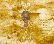
True, there is nothing out of the already known.Map of New Spain (Nvova Spagna) by Ignazio Danti for @HELLBOY. You're not gonna find anything remarkable though, imo.
Mexico - Egnazio Danti - Google Arts & Culture
The country of new Spain is similar to the old except for its harsher mountains, which are not as easy to climb and some of them extend for more than 500 miles. In this province there are great rivers, beautiful springs of fresh water and rich woods of Pines, Cypresses, Cedars, Oaks and other types of trees in the mountains and plains. In said province are many mines of Gold, Silver, Tin, Copper and Iron. There are very pleasant Hills and countrysides, and they are always covered with green grass, in all the seasons* of the year and in many places they gather from … …*, to be …* during the Equinox.
Among the biggest and major cities of this province the chief city is the great city of Mexico, which floats in water as Venice (Vin...ia) but in a lake whose Southern (Ostro) side, where big ships** enter, is composed of fresh water, while the Northern (Tramontana) half where the city is located is composed of salt water. This lake is surrounded by mountains on all sides except between North-East (Greco) and North and its circumference is about 120 miles. The inhabitants of such city are today all christians. Men of scarse acumen*** but peaceful, they learn with great ease everything is taught to them, thing I can tell by personal experience … friar Alfonso fr. Dis. Domenico**** (born in said city by mexican father) who came in Spain and Italy (Italia) and in a short time made great improvements not only in languages but also in philosophy and Theology. And as the aforementioned has told me, it’s already many years that the King (Re) of Spain ordered the construction of a university where are more than 4000 students. In this city there are 100025 houses as some write and how the aforementioned friar Alfonso confirmed me, who, having seen Venice, said it was two-thirds smaller than Mexico, even though Cortes (Cortese) said there were only 70000 souls, unless the printing***** is wrong and means 700000.
This map was made using the coastlines drawn by the Castilians (Castigliani) in their nautical Charts while the remaining interior was taken from the reports of Cortes and others who went there, and from some maps of said province.
* can't read what is written
** not sure he is talking of ships, because the term is unreadable. So I’m just saying ‘ships’ based on what I already know and what is logic for the context.
*** Don't shoot the messenger!!! The text uses the word ‘invetion’, with a trait upon the ‘e’ probably indicating a following ‘n’. Therefore we have ‘invention’, possibly meaning ‘acumen’… but hey, translate it as you want!
**** can’t tell why he repeats ‘fr.’ two times and what ‘dis.’ means
***** it’s not very clear what is written. I think ‘unless the printing’ is the best fitting scenario, possibly hinting at a mistake done in various books of that time reporting wrong datas.
Danti's maps are quite meager in terms of historical informations, when compared to those by Bonsignori. They are hard to translate mostly due to the worse condition of the maps and the use of lines in the captions probably to write sentences without going up and down with words and letters (problem is that the ink of those lines covers the letters making it difficult to understand sometimes).
Overall the history contained in these maps is more in line with that taught in the XVII century, after the 'new wave' of historical matters started by Scaliger at the end of the XVI century. It seems a little weird to see how both the history told and the language used by Danti seem more modern than those used by Bonsignori!
When it comes to this map I can't add anything. Maybe you @HELLBOY can say something, although I think we are dealing with details...

- What I was noticing, is the fact that it depicts Tenochtitlan as Mexico 1565 only 43 years after the fall of Tenochtitlan and in fact places a Tenochtitlan city below Mexico City.
- If you align the map of Cortes 1521, the map of Upsala 1550 in this placement, they coincide with the Temix - Titan of Cortes. They all have Chapultepec in the lower left corner.
https://www.loc.gov/resource/gdcwdl...wpTz06S1cNjGZ2A0&r=-0.541,0.101,1.669,0.657,0
https://www.loc.gov/resource/gdcwdl...L0Es7Dcmk5b8Gmg&r=-0.035,-0.026,1.075,0.423,0
- I have a current timeline of the city and I believe it did not grow at all for centuries. I also placed the images in the same perspective, the difference is that in this one the lake of Texcoco is present on the right.
- You can see how what is now the historic center was kept at bay and the city did not begin to grow until after 1850. 1810 Independence of Mexico, 1910 Mexican Revolution.
- I see how in the ancient maps they do know the size of Lake Chapala but not the size of Lake Texcoco, only the small area of Tenochtitlan is shown.
- I remember that in Ogilby's engravings of old and new Mexico you can see a lake already drying up in 1671 and the transformation of the city with architecture out of the ordinary.
The rapid transformation from one city to another.
The absence of pyramids that crowned the center of the city.
Although today there are quite a few around the city. Tlatelolco Google Maps b1!8m2!3d19.4523693!4d-99.1384147!3m4!1s0x85d1f92383c87ca7:0x179e8c60050933eb!8m2!3d19.4512852!4d-99.1375018
There in the Parish of Santiago Apostol, I think it is old enough to have some alternative history, it has murals of San Cristobal el Cinocéfalo, no more, there I leave related links of mine. They also have the eagle ridden by someone, which reminds me of Vishnu riding Garuda and Zeus riding the Eagle. I think this may be related to Preste Juan - San Cristobal - Cristobal Colon.
Sixteenth century maps from Tuscany
The secret of the twins Quetzalcoatl and Xolotl
Attachments
Last edited:
