I am an adherent of Heinsohn, viz New Chronology. Yeah, the shortening of modern chronology and displaced identities of nations is what we're here to research. Thanks!here a link to Heinsohn research. He shows how according to stratigraphy the 'Roman Empire' ended in the 10th century AD, so in a time very close to the authors mentioned in the article ascribed to the 11th century (https://www.q-mag.org/_search.html?req=Heinsohn). Maybe they were not crazy.
You are using an out of date browser. It may not display this or other websites correctly.
You should upgrade or use an alternative browser.
You should upgrade or use an alternative browser.
D
Deleted member 37
Guest
I'm not sure about the displacement of geographical features. I'm more inclined to think it's the imprecision of the author of the maps. Look at the Niger river. It is shown linked to the Senegal river as if it is its mouth, which should be down in the South near the Benin Reign, as shown in a previous map. And Bonsignori also says that its source is in the same mountains from which the Nile comes out, which is false, as we know. Yes maybe the river cahanged its course too, but isn't it too much?
Interesting point. Apparently (if the map is to be believed), these islands (in modern form) appeared relatively recently. It is unlikely that they would not have noticed the missing (on the old map) islands (if these islands had them; those who provided data for the map), given that some islands are marked (perhaps the water level was higher in that area; only the high part of the islands was visible). Which suggests that someone was in those areas. And they would, unlikely, not have noticed other islands nearby (which are in the present tense).
Or, someone deliberately created such a marker to distract attention (which also cannot be ruled out).
But overall, this map looks very similar to what should be under the sand and at a higher water level (which was provided by water runoff from the mountains that are now under the sand; as a matter of conjecture). The mountains (which provided the water flow) were backfilled with sand. Therefore, there was a drop in the water level in the area.
Unlike Scythia, there is little distortion here, as the proximity to the equator (and distance from the poles) reduces distortion on a flat map by Mercator projection (and similar analogs).
That is why the map of Scythia (and other circumpolar areas) is so difficult to parse. Ideally (in my opinion) you need a detailed (modern) map with the azimuth projection, to be able to see the contours (as old cartographers saw them) and the outlines of the rivers and mountains. Then, there would be a better chance of seeing something.
D
Deleted member 37
Guest
Nineteenth map (part 2) titled ‘Nubia’ by Stefano Bonsignori. I didn’t notice an interesting text on the right top of the map.

The ancient Egyptians (Egizzij) did not know where the sources of the Nile (Nilo) were, nor the Ethiopians (Etiopi) knew about the effect its waters have, that is the floods those waters cause in Egypt (Egitto). But they found out it during the reign of the Sultans (Sultani), when the Egyptians were forced to pay a substantial tribute to the Emperor (Impatore) of the Ethiopians in order to prevent him from diverging the Nile into the Red (Rosso) sea, and they still pay it.
I’ve never heard about such a thing before. The Ethiopians and their dear Prester John were threatening an entire nation with the promise to kill all of them if they were not paid. Imagine what disaster that would be for the Mediterranean too, I suppose. So in the previous post I talked about the Niger river modern path and its difference in comparison to that imagined by Bonsignori. I’m not sure anymore of what I said. In fact there’s a chance that the knowledge of diverting a river’s path and using it as a weapon against an enemy could be at the origin of the Sahara desert, where it’s shown that once upon a time various rivers and lakes were present.
I’ve never heard about such a thing before. The Ethiopians and their dear Prester John were threatening an entire nation with the promise to kill all of them if they were not paid. Imagine what disaster that would be for the Mediterranean too, I suppose. So in the previous post I talked about the Niger river modern path and its difference in comparison to that imagined by Bonsignori. I’m not sure anymore of what I said. In fact there’s a chance that the knowledge of diverting a river’s path and using it as a weapon against an enemy could be at the origin of the Sahara desert, where it’s shown that once upon a time various rivers and lakes were present.
Last edited by a moderator:
Safranek
Core Member
- Joined
- Sep 16, 2020
- Messages
- 477
- Reaction score
- 1,572
Imagine the execution of such a feat. Either they had some heavy machinery to accomplish something like this or, if done without machinery, the scope of human labor involved would be hard to imagine. Can one Emperor be able to plan and execute such a task in a lifetime? Just how many miles of fresh riverbed are we talking about?the Egyptians were forced to pay a substantial tribute to the Emperor (Impatore) of the Ethiopians in order to prevent him from diverging the Nile into the Red (Rosso) sea
Additionally, what is the city of Mensuria (dangerously close to Manchuria) doing in Nubia? And the river Fiume, which is the old name of Trieste.
D
Deleted member 37
Guest
The word 'fiume' is the Italian for 'river'.And the river Fiume, which is the old name of Trieste.
I've searched for info here and there about this threat posed by the Ethiopians some centuries ago. It doesn't seem historians are taking this story in consideration as much as they are not taking into consideration the Ethiopian Empire composed of fifteen reigns. It had to be very powerful and rich (maybe through extorsion) to complete such feats.Imagine the execution of such a feat. Either they had some heavy machinery to accomplish something like this or, if done without machinery, the scope of human labor involved would be hard to imagine. Can one Emperor be able to plan and execute such a task in a lifetime? Just how many miles of fresh riverbed are we talking about?
edit: I'm still wondering about their capital being moved to the South. It seems the Portuguese were the ones putting an end to their empire. Today they show it was confined more or less on the region of modern Ethiopia, but the evidence of these maps shows it was originally centered around modern Sudan and in any case on the Nile river.
Last edited by a moderator:
Safranek
Core Member
- Joined
- Sep 16, 2020
- Messages
- 477
- Reaction score
- 1,572
I found a city seemingly corresponding with Dangala at the top of your map, closely named Dongola in Sudan. Could it have kept the name through all this time?
Dongola · Sudan
and...
Old Dongola - Wikipedia
Coincidentally (or not according to the book in my above post), Dangala is located in the province of Makuria and their Royal Standard according to the Book of Knowledge of All Kingdoms just happens to be the same as the Kingdom of Hungary.


I'm going to try and get through more of that book.
Dongola · Sudan
and...
Old Dongola - Wikipedia
Coincidentally (or not according to the book in my above post), Dangala is located in the province of Makuria and their Royal Standard according to the Book of Knowledge of All Kingdoms just happens to be the same as the Kingdom of Hungary.
I'm going to try and get through more of that book.
I
iseidon
Guest
Speaking of the Hungarian trail in Africa. About two years ago, I was looking through towns in the bays. And in Madagascar, I found an interesting story about the town of Maroantsetra. It was founded by an 18th century Hungarian military officer, Maurice Benyovszky. According to Wikipedia, he was captured by Russia during the war between Russia and the Bar Confederation in 1769. He was exiled to Kamchatka. Escaped via Macau and Mauritius to France. Later, in 1773, he went to Madagascar on a trade mission. Faced with serious problems with the climate, terrain, and local Sakalawa people, he left the faction in 1776. This sounds very much like a description of an exploration of the island or an unsuccessful war effort. It is possible that there was no exile. But there was a reconnaissance of the territory around the conditional Turkestan-Siberia. Where it was impossible to sneak in. Pay attention to the dates, if they can be trusted. At the same time, there was Pugachev's rebellion and the War of Independence. From 1781 to 1783 he was in the United States on the recommendation of Benjamin Franklin. And had contact with George Washington.I found a city seemingly corresponding with Dangala at the top of your map, closely named Dongola in Sudan. Could it have kept the name through all this time?
Dongola · Sudan
and...
Old Dongola - Wikipedia
Coincidentally (or not according to the book in my above post), Dangala is located in the province of Makuria and their Royal Standard according to the Book of Knowledge of All Kingdoms just happens to be the same as the Kingdom of Hungary.
I'm going to try and get through more of that book.
There are many other interesting (very interesting) points about his life.
Even the wikipedia expresses doubts about his biography:
Much of what Benyovszky claimed to have done in Poland, Kamchatka, Japan, Formosa, and Madagascar is questionable at best, but in any case has left no lasting traces in the history of war, exploration, or colonialism.
By the way, the etymology of the word Madagascar is not clear. For example, I clearly see the root "kar" ("black" in Turkic languages) at the end. Which is not unreasonable, in my opinion.
So perhaps there is a Hungarian trail in Africa. I attribute this to the fact that each culture was given its own heroes, composers, writers, artists, etc. These heroes are collective images of real people from the old world (or generated from streams of information about the ancient world + added elements from the new world). According to its position in the new hierarchy, each group-nation received a corresponding number of heroes and cultural layers. Perhaps somewhere there was an interaction between the old world and the new world, which gave birth to new unique cultural layers. In my opinion, this well explains the regression in culture and architecture at the beginning of the 20th century (which was covered up by the words "avant-garde" and "constructivism").
Last edited by a moderator:
D
Deleted member 37
Guest
Translating the new maps by Ignazio Danti is a pain in the $$!
The problem with this new maps is the fact that words are intertwined with the lines upon which sentences were written. And here I can already see something really peculiar and deserving a reflection.
They say Danti (Ignazio Danti - Wikipedia) was exiled by his patrons in Florence and substituted by Bonsignori (Stefano Bonsignori (cartographer) - Wikipedia), but unreadable texts apart (for the reasons I told before), it is absolutely fascinating to see how the grammar, the lettering and the contents proposed by Bonsignori already 'feel' older.
Danti's content I've read until now seems concerned more with 'recent' history or in any case he is not going to touch the same 'mythological' aspects proposed by Bonsignori. His narrative feels more in line with our own, as if the cut with the 'mythological' part was already happened.
Not only that but the Italian used by Danti is far more understandable and modern compared to the one used by Bonsignori. I'm not going in detail on this subject because I fear to give incorrect informations though.
When it comes to the lettering, Danti is almost modern, while Bonsignori used plenty of those abbreviations very popular in Latin writings from the middle-ages. No trace of it in Danti. Here below an example from Bonsignori:

iqli no pò stands for i qUAli noN pERò
In modern Italian it would be written in a different order, the same used by Danti, as "i quali però non...". It may seem an insignificant change but it's not. Just observe how many times I mess up the order of the sentence with my English, sometimes making it difficult for you to understand what I'm saying .
.
The problem with this new maps is the fact that words are intertwined with the lines upon which sentences were written. And here I can already see something really peculiar and deserving a reflection.
They say Danti (Ignazio Danti - Wikipedia) was exiled by his patrons in Florence and substituted by Bonsignori (Stefano Bonsignori (cartographer) - Wikipedia), but unreadable texts apart (for the reasons I told before), it is absolutely fascinating to see how the grammar, the lettering and the contents proposed by Bonsignori already 'feel' older.
Danti's content I've read until now seems concerned more with 'recent' history or in any case he is not going to touch the same 'mythological' aspects proposed by Bonsignori. His narrative feels more in line with our own, as if the cut with the 'mythological' part was already happened.
Not only that but the Italian used by Danti is far more understandable and modern compared to the one used by Bonsignori. I'm not going in detail on this subject because I fear to give incorrect informations though.
When it comes to the lettering, Danti is almost modern, while Bonsignori used plenty of those abbreviations very popular in Latin writings from the middle-ages. No trace of it in Danti. Here below an example from Bonsignori:
iqli no pò stands for i qUAli noN pERò
.- Joined
- Aug 26, 2020
- Messages
- 243
- Reaction score
- 217
I did not read all the thread, but René Guenon once wrote that Ethiopia was just another name for Atlantis.
Knowing the city-state of Atlantis is the Eye of the Sahara, and that the Sahara desert was once green, and that Fomenko said Alexandria was the previous capital of the Roman Empire (Constantinople being the second), we can assume that Egypt (Aegyptus, from where comes the word "gypsy") was originally Rome, maybe a part of Atlantis, and later they migrated to the balkans, creating a new Rome there.
Knowing the city-state of Atlantis is the Eye of the Sahara, and that the Sahara desert was once green, and that Fomenko said Alexandria was the previous capital of the Roman Empire (Constantinople being the second), we can assume that Egypt (Aegyptus, from where comes the word "gypsy") was originally Rome, maybe a part of Atlantis, and later they migrated to the balkans, creating a new Rome there.
This has been a very intriguing thread. I will make several posts that could help answer questions posed in the thread.
I believe it was during the discussion about the map of Sicily/Sardinia/Corsica that the Hun conquest of the Roman Empire from the south came up. The thread and comments below address that:
I read the transcript of an excellent lecture posted by dreamtime. A Hungarian writer/researcher named Toth Gyula uses Hungarian national chronicles to reexamine the reasons for and timing of Attila the Huns' conquest. It turns out that a portion of his army was sent to Spain, conquered through North Africa as the Vandals, ruled Carthage for 100 years and conquered Italy and the Mediterranean islands from the south. I have included a quote, but it is worth your time to read the whole transcript. He dives deep into numerous chronologies and calendar systems to understand the Hungarian timeline he is suggesting. He shows a phantom period of over 300 years. He puts together a pretty convincing thesis that Attila was a Christian ruler and two of his sons were Constantine and Charlemagne, who were contemporaries of each other and ruled the eastern and western halves of the Christian Holy Roman Empire.
From Scythia to Maghreb: Beyond the Phantom Middle Ages
"...Morocco, Algeria, and Tunisia has a collective name. This area is called “Maghreb".... it seems that the Hungar captains had settled in North-Western Africa, the ones that Atilla sent against Sultan Miramammona, the ones who didn't dare return before the eyes of Atilla, because they were late for the Battle of the Catalaunian plains. Now then, there these Hungar captains founded this 100 year long Alan-Vandal blooming empire, and starting from there, from North Africa, they went on to attack the Roman colonies, Rome itself, and occupied many Mediterranean islands."
A topic that came up in the narrative of several maps was Noah, his son Ham and Ham's son Canaan. It was interesting to read about them as active people throughout the history of Europe. It seems like Ham and Canaan just ran from place to place causing trouble, with Noah chasing them down and setting them straight. The Albanian parallels to language and geography were strong, thank you to that poster.
Someone brought up the Curse of Canaan/Curse of Ham. Here is my recent find regarding that:
Here's a link and quote from Judah, a writer/researcher on wordpress. He writes a lot regarding Hebrews and Black Hebrew Israelites, delving into dna haplogroup research, apocryphal Bibical books (especially Book of Jubilees) and Jewish writings. He has a great series of articles on the Lost Tribes of Israel. He has some strong opinions and is quite religious, but has some well researched alternative viewpoints.
Anyway, he puts forth a pretty strong argument that Ham had sex with Noah's wife/his own mother when Noah was passed out drunk and Ham walked in and saw her naked. Cannan was the product of that incest, and that's why he is referred to the way he is and why he is cursed by Noah.
Caucasian Canaanites: Understanding Europe and the LGBTQ Era - Condir
"And the sons of Noah, that went forth of the ark, were Shem, and Ham, and Japheth: and Ham is the father of Canaan. These are the three sons of Noah: and of them was the whole earth overspread. – Genesis 9:18-19"
"And Ham, the father of Canaan, saw the nakedness of his father, and told his two brethren without. – Genesis 9:22"
Ham came into his father’s tent and saw Noah’s nakedness. Why is that even a problem? Is it so bad for a full-grown man to see another man naked? Is that enough reason to curse a man’s descendant to perpetual servitude? After all, it was a crime committed by Ham, not Canaan.
"The nakedness of thy father’s wife shalt thou not uncover: it is thy father’s nakedness. – Leviticus 18:8"
This text is simply saying a man’s nakedness is having sex with his wife. Leviticus 18 was talking about incestuous relationships, not looking at unclothed bodies of close relatives. To uncover nakedness is to remove clothes with a sexual goal in mind....Putting this in the context of Genesis 9, Ham must have had sex with his father’s wife....The incest incident resulted in a pregnancy and the offspring was Canaan. This is why the Bible lists Canaan along with Noah’s son because he is technically his stepson from his wife with Ham....To make matters worse, Ham went out and bragged about his ‘conquest’ to his brothers....Fortunately, Ham’s brothers were wiser than he. Take a look at what his brothers did.
"And Shem and Japheth took a garment, and laid it upon both their shoulders, and went backward, and covered the nakedness of their father; and their faces were backward, and they saw not their father’s nakedness. – Genesis 9:23"
Noah finding [out] at birth....would explain how Noah knew the child’s name and gender. It would also explain the other meaning of Canaan which people don’t talk about – humiliate."
***I had an odd thought as I was composing this post***
Canaan really seems to get away with a lot more than he should! He's moving into other people's lands and tents and being really disrespectful in general. What if this privilege is related to his parentage/ bloodline percentages? Because Canaan's mother was Noah's wife and not Ham's wife, Canaan would have been one step closer to Adam than the other sons of Ham, Shem and Japheth (so more pure blood). Ham may have purposely impregnated Noah's wife as a power play to make his child more special than the other children!!! Make HIS child the designated heir of Noah. But it backfired...
This suggestion is based on Sumerian stories regarding Annunaki traditions of siblings and half-siblings having children with each other to concentrate their bloodlines and position the child as the strongest heir.
I know this is a radical post (among radical posts). When I first read Jonah's supposition about Canaan's parentage it made a lot of sense. It finally explained a couple of confusing things about that whole passage in Genesis 9 and in the Book of Jubilees (which includes a lot more details about the whole Noah/Ham/Canaan fiasco and everything else too).
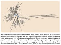
One more thing, I will look for the graphic of it. When mitochondrial dna (passed from mothers) is traced back, there is a point where it narrows down to four women. If it were just the wives of Shem, Ham and Japheth having kids, then it should narrow to three women. But there's four. This means Noah's wife kept having kids, either with Noah or Ham. This helps explain why it was important to mention Canaan with the three sons in Genesis9:18, because together they represented four bloodlines from four women. I'm pretty sure that Judaism is traced on the mother's side, that you are not a Jew unless your mother is a Jew.
I believe it was during the discussion about the map of Sicily/Sardinia/Corsica that the Hun conquest of the Roman Empire from the south came up. The thread and comments below address that:
I read the transcript of an excellent lecture posted by dreamtime. A Hungarian writer/researcher named Toth Gyula uses Hungarian national chronicles to reexamine the reasons for and timing of Attila the Huns' conquest. It turns out that a portion of his army was sent to Spain, conquered through North Africa as the Vandals, ruled Carthage for 100 years and conquered Italy and the Mediterranean islands from the south. I have included a quote, but it is worth your time to read the whole transcript. He dives deep into numerous chronologies and calendar systems to understand the Hungarian timeline he is suggesting. He shows a phantom period of over 300 years. He puts together a pretty convincing thesis that Attila was a Christian ruler and two of his sons were Constantine and Charlemagne, who were contemporaries of each other and ruled the eastern and western halves of the Christian Holy Roman Empire.
From Scythia to Maghreb: Beyond the Phantom Middle Ages
"...Morocco, Algeria, and Tunisia has a collective name. This area is called “Maghreb".... it seems that the Hungar captains had settled in North-Western Africa, the ones that Atilla sent against Sultan Miramammona, the ones who didn't dare return before the eyes of Atilla, because they were late for the Battle of the Catalaunian plains. Now then, there these Hungar captains founded this 100 year long Alan-Vandal blooming empire, and starting from there, from North Africa, they went on to attack the Roman colonies, Rome itself, and occupied many Mediterranean islands."
A topic that came up in the narrative of several maps was Noah, his son Ham and Ham's son Canaan. It was interesting to read about them as active people throughout the history of Europe. It seems like Ham and Canaan just ran from place to place causing trouble, with Noah chasing them down and setting them straight. The Albanian parallels to language and geography were strong, thank you to that poster.
Someone brought up the Curse of Canaan/Curse of Ham. Here is my recent find regarding that:
Here's a link and quote from Judah, a writer/researcher on wordpress. He writes a lot regarding Hebrews and Black Hebrew Israelites, delving into dna haplogroup research, apocryphal Bibical books (especially Book of Jubilees) and Jewish writings. He has a great series of articles on the Lost Tribes of Israel. He has some strong opinions and is quite religious, but has some well researched alternative viewpoints.
Anyway, he puts forth a pretty strong argument that Ham had sex with Noah's wife/his own mother when Noah was passed out drunk and Ham walked in and saw her naked. Cannan was the product of that incest, and that's why he is referred to the way he is and why he is cursed by Noah.
Caucasian Canaanites: Understanding Europe and the LGBTQ Era - Condir
"And the sons of Noah, that went forth of the ark, were Shem, and Ham, and Japheth: and Ham is the father of Canaan. These are the three sons of Noah: and of them was the whole earth overspread. – Genesis 9:18-19"
"And Ham, the father of Canaan, saw the nakedness of his father, and told his two brethren without. – Genesis 9:22"
Ham came into his father’s tent and saw Noah’s nakedness. Why is that even a problem? Is it so bad for a full-grown man to see another man naked? Is that enough reason to curse a man’s descendant to perpetual servitude? After all, it was a crime committed by Ham, not Canaan.
"The nakedness of thy father’s wife shalt thou not uncover: it is thy father’s nakedness. – Leviticus 18:8"
This text is simply saying a man’s nakedness is having sex with his wife. Leviticus 18 was talking about incestuous relationships, not looking at unclothed bodies of close relatives. To uncover nakedness is to remove clothes with a sexual goal in mind....Putting this in the context of Genesis 9, Ham must have had sex with his father’s wife....The incest incident resulted in a pregnancy and the offspring was Canaan. This is why the Bible lists Canaan along with Noah’s son because he is technically his stepson from his wife with Ham....To make matters worse, Ham went out and bragged about his ‘conquest’ to his brothers....Fortunately, Ham’s brothers were wiser than he. Take a look at what his brothers did.
"And Shem and Japheth took a garment, and laid it upon both their shoulders, and went backward, and covered the nakedness of their father; and their faces were backward, and they saw not their father’s nakedness. – Genesis 9:23"
Noah finding [out] at birth....would explain how Noah knew the child’s name and gender. It would also explain the other meaning of Canaan which people don’t talk about – humiliate."
***I had an odd thought as I was composing this post***
Canaan really seems to get away with a lot more than he should! He's moving into other people's lands and tents and being really disrespectful in general. What if this privilege is related to his parentage/ bloodline percentages? Because Canaan's mother was Noah's wife and not Ham's wife, Canaan would have been one step closer to Adam than the other sons of Ham, Shem and Japheth (so more pure blood). Ham may have purposely impregnated Noah's wife as a power play to make his child more special than the other children!!! Make HIS child the designated heir of Noah. But it backfired...
This suggestion is based on Sumerian stories regarding Annunaki traditions of siblings and half-siblings having children with each other to concentrate their bloodlines and position the child as the strongest heir.
I know this is a radical post (among radical posts). When I first read Jonah's supposition about Canaan's parentage it made a lot of sense. It finally explained a couple of confusing things about that whole passage in Genesis 9 and in the Book of Jubilees (which includes a lot more details about the whole Noah/Ham/Canaan fiasco and everything else too).
One more thing, I will look for the graphic of it. When mitochondrial dna (passed from mothers) is traced back, there is a point where it narrows down to four women. If it were just the wives of Shem, Ham and Japheth having kids, then it should narrow to three women. But there's four. This means Noah's wife kept having kids, either with Noah or Ham. This helps explain why it was important to mention Canaan with the three sons in Genesis9:18, because together they represented four bloodlines from four women. I'm pretty sure that Judaism is traced on the mother's side, that you are not a Jew unless your mother is a Jew.
Last edited:
Here is a diagram representing the mitochondrial DNA bottleneck that occurred because of the flood. This is from creationist Dr. Nathaniel Jeanson, he only points out the three branches he is interested in. But I see a clear fourth branch which would be Noah's wife.
Attachments
The Chichimecs who remained in the mountains (they lived in deep caves) left the new people in quiet possession of their lands, and learned some of their customs, to the extent that they began to build huts, elect governors and live according to their laws.
Deuteronomy 32:21
They have moved me to jealousy with that which is not God; they have provoked me to anger with their vanities: and I will move them to jealousy with those which are not a people; I will provoke them to anger with a foolish [#H5036 nabal: stupid ; wicked, vile person] nation.
Attachments
Code For Faith
Member
We are all the offspring of Noah since only him, his wife, his three sons and their wives -- and a lot of animals -- made it on the ark.1. were deutch people really descended from Noah?
"And Noah was six hundred years old when the flood of waters was upon the earth. And Noah went in, and his sons, and his wife, and his sons' wives with him, into the ark, because of the waters of the flood." [Genesis 7:6-7]
- Joined
- Aug 25, 2020
- Messages
- 340
- Reaction score
- 956
I find it fascinating that maps from a century later [ca. 1680] (link below) still have the same town/city names that sound like they belong in fantasy books but seemingly existed and we still have no idea what really happened to them.. Amazing...Seventh map titled ‘Trogloditica’ by Stefano Bonsignori.
Accuratissima totius Asiæ tabula in omnes partes divisa (click Advanced Zoom to see details)
(A hand colored map of Asia covering Saudi Arabia, Russia, India, China, Japan to Southeast Asia.)
Code For Faith
Member
Interesting, I just saw the story of the Gauls being called this way because of the floods on an old French map: Mappe Monde Celeste Terrestre et Historique 1787It took the name Gaul from Celtus (Galate) son of Egyptian Hercules (Ercole Egizzio), or from the Gauls (Galli) first inhabitants of that land, so called by the Arameans (Aramei) and the Hebrews (Ebrei), because they ran into danger due to the waters of the flood.
But they also name a different founder called "Pharamond". May a question of who settled there first VS who was the first political leader? Or is it the same man under two different names?
Anyway, it's nice to see some matching information from unrelated material!
Last edited:
- Joined
- Oct 5, 2020
- Messages
- 194
- Reaction score
- 875
Do you have the translation of the map that talks about Mexico? Mexico - Egnazio Danti - Google Arts & Culture
D
Deleted member 37
Guest
yessir, waitDo you have the translation of the map that talks about Mexico? Mexico - Egnazio Danti - Google Arts & Culture
- Joined
- Oct 3, 2020
- Messages
- 291
- Reaction score
- 239
looking at this map... is that an unlabelled Pompei?!?!
(also seems like a lot of plotting was done from Napoli!!)
D
Deleted member 37
Guest
Map of New Spain (Nvova Spagna) by Ignazio Danti for @HELLBOY. You're not gonna find anything remarkable though, imo.
Mexico - Egnazio Danti - Google Arts & Culture

The country of new Spain is similar to the old except for its harsher mountains, which are not as easy to climb and some of them extend for more than 500 miles. In this province there are great rivers, beautiful springs of fresh water and rich woods of Pines, Cypresses, Cedars, Oaks and other types of trees in the mountains and plains. In said province are many mines of Gold, Silver, Tin, Copper and Iron. There are very pleasant Hills and countrysides, and they are always covered with green grass, in all the seasons* of the year and in many places they gather from … …*, to be …* during the Equinox.
Among the biggest and major cities of this province the chief city is the great city of Mexico, which floats in water as Venice (Vin...ia) but in a lake whose Southern (Ostro) side, where big ships** enter, is composed of fresh water, while the Northern (Tramontana) half where the city is located is composed of salt water. This lake is surrounded by mountains on all sides except between North-East (Greco) and North and its circumference is about 120 miles. The inhabitants of such city are today all christians. Men of scarse acumen*** but peaceful, they learn with great ease everything is taught to them, thing I can tell by personal experience … friar Alfonso fr. Dis. Domenico**** (born in said city by mexican father) who came in Spain and Italy (Italia) and in a short time made great improvements not only in languages but also in philosophy and Theology. And as the aforementioned has told me, it’s already many years that the King (Re) of Spain ordered the construction of a university where are more than 4000 students. In this city there are 100025 houses as some write and how the aforementioned friar Alfonso confirmed me, who, having seen Venice, said it was two-thirds smaller than Mexico, even though Cortes (Cortese) said there were only 70000 souls, unless the printing***** is wrong and means 700000.
This map was made using the coastlines drawn by the Castilians (Castigliani) in their nautical Charts while the remaining interior was taken from the reports of Cortes and others who went there, and from some maps of said province.
* can't read what is written
** not sure he is talking of ships, because the term is unreadable. So I’m just saying ‘ships’ based on what I already know and what is logic for the context.
*** Don't shoot the messenger!!! The text uses the word ‘invetion’, with a trait upon the ‘e’ probably indicating a following ‘n’. Therefore we have ‘invention’, possibly meaning ‘acumen’… but hey, translate it as you want!
**** can’t tell why he repeats ‘fr.’ two times and what ‘dis.’ means
***** it’s not very clear what is written. I think ‘unless the printing’ is the best fitting scenario, possibly hinting at a mistake done in various books of that time reporting wrong datas.
Danti's maps are quite meager in terms of historical informations, when compared to those by Bonsignori. They are hard to translate mostly due to the worse condition of the maps and the use of lines in the captions probably to write sentences without going up and down with words and letters (problem is that the ink of those lines covers the letters making it difficult to understand sometimes).
Overall the history contained in these maps is more in line with that taught in the XVII century, after the 'new wave' of historical matters started by Scaliger at the end of the XVI century. It seems a little weird to see how both the history told and the language used by Danti seem more modern than those used by Bonsignori!
When it comes to this map I can't add anything. Maybe you @HELLBOY can say something, although I think we are dealing with details...
Mexico - Egnazio Danti - Google Arts & Culture
Among the biggest and major cities of this province the chief city is the great city of Mexico, which floats in water as Venice (Vin...ia) but in a lake whose Southern (Ostro) side, where big ships** enter, is composed of fresh water, while the Northern (Tramontana) half where the city is located is composed of salt water. This lake is surrounded by mountains on all sides except between North-East (Greco) and North and its circumference is about 120 miles. The inhabitants of such city are today all christians. Men of scarse acumen*** but peaceful, they learn with great ease everything is taught to them, thing I can tell by personal experience … friar Alfonso fr. Dis. Domenico**** (born in said city by mexican father) who came in Spain and Italy (Italia) and in a short time made great improvements not only in languages but also in philosophy and Theology. And as the aforementioned has told me, it’s already many years that the King (Re) of Spain ordered the construction of a university where are more than 4000 students. In this city there are 100025 houses as some write and how the aforementioned friar Alfonso confirmed me, who, having seen Venice, said it was two-thirds smaller than Mexico, even though Cortes (Cortese) said there were only 70000 souls, unless the printing***** is wrong and means 700000.
This map was made using the coastlines drawn by the Castilians (Castigliani) in their nautical Charts while the remaining interior was taken from the reports of Cortes and others who went there, and from some maps of said province.
* can't read what is written
** not sure he is talking of ships, because the term is unreadable. So I’m just saying ‘ships’ based on what I already know and what is logic for the context.
*** Don't shoot the messenger!!! The text uses the word ‘invetion’, with a trait upon the ‘e’ probably indicating a following ‘n’. Therefore we have ‘invention’, possibly meaning ‘acumen’… but hey, translate it as you want!
**** can’t tell why he repeats ‘fr.’ two times and what ‘dis.’ means
***** it’s not very clear what is written. I think ‘unless the printing’ is the best fitting scenario, possibly hinting at a mistake done in various books of that time reporting wrong datas.
Danti's maps are quite meager in terms of historical informations, when compared to those by Bonsignori. They are hard to translate mostly due to the worse condition of the maps and the use of lines in the captions probably to write sentences without going up and down with words and letters (problem is that the ink of those lines covers the letters making it difficult to understand sometimes).
Overall the history contained in these maps is more in line with that taught in the XVII century, after the 'new wave' of historical matters started by Scaliger at the end of the XVI century. It seems a little weird to see how both the history told and the language used by Danti seem more modern than those used by Bonsignori!
When it comes to this map I can't add anything. Maybe you @HELLBOY can say something, although I think we are dealing with details...
Last edited by a moderator:
D
Deleted member 37
Guest
Well, here they say the Nile river was sometimes called 'Ocean', so...I did not read all the thread, but René Guenon once wrote that Ethiopia was just another name for Atlantis.
Pharamond was considered to be the first King of the Franks, who are nowadays considered to be a different entity from the Gauls. It seems that France took its name from the Ile-de-France, where Paris is located, only during the XVII century according to the maps we have. Before that century the country was called Gaul and it inhabitants the Gauls. Even the Kings were referred to as the Kings of Gaul...Interesting, I just saw the story of the Gauls being called this way because of the floods on an old French map: Mappe Monde Celeste Terrestre et Historique 1787
But they also name a different founder called "Pharamond". May a question of who settled there first VS who was the first political leader? Or is it the same man under two different names?
I think it's more probable it is Torre del Greco by its position, the city where the stele talking about Pompeii and Herculaneum buried in 1631 is located.looking at this map... is that an unlabelled Pompei?!?!
(also seems like a lot of plotting was done from Napoli!!)
(You're preaching to the choir, @_harris
 )
)
Similar threads
- Replies
- 1
- Views
- 551
- Replies
- 4
- Views
- 11K
- Replies
- 130
- Views
- 16K