Archive
Old SH Archive
- Joined
- Sep 8, 2020
- Messages
- 17,737
- Reaction score
- 3,168
Exeter is a cathedral city in Devon, England, with a population of 130,428 (mid-2018 est.). The city is located on the River Exe approximately 36 miles (58 km) northeast of Plymouth and 65 miles (105 km) southwest of Bristol.
Exeter - Wikipedia


This city is old. So old, that Wikipedia doesn't even list a date for the founding, listing it as "time immemorial".
This site attributes most of the settlement to the Romans:
The wall made it though. Behold, a nearly 2,000 year old wall!

Unfortunately, a lot of the other historic remnants of this ageless city have not fared so well... and wouldn't you know it, it's the relatively recent past to blame! From the blog Demolition Exeter:
The reason I started this blog was because of an argument I had recently with someone who claimed that Exeter was a lovely city with 'lots of historic buildings'. I was surprised as I didn't see how anyone could think that Exeter had 'lots of historic buildings' when so many of them have been destroyed within the last century.
It's true that the ancient heart of Exeter has a number of exceptionally fine and historically important buildings, and you can almost count them on the fingers of two hands: the Cathedral, the Castle at Rougemont, the Guildhall, a number of medieval properties in the Cathedral Close, three superb terraces of Georgian townhouses, St Nicholas's Priory, about a dozen surviving timber-frame merchant houses, a few interesting 15th century parish churches and one street of good Victorian public buildings, including the remains of the Higher Market and the neo-Gothic museum. Around 70% of the City Wall also survives, although this is largely overlooked...
...Another widely-believed fallacy is that Exeter was destroyed during World War Two. It was not. It has been said to me more than once, and by more than one person, that the city council merely finished what the Germans started. But even this is untrue in some aspects, as the damage inflicted on the city in 1942 didn't even set a precedent. The city authorities had been pulling vast areas of the city down from the end of the 19th century onwards.

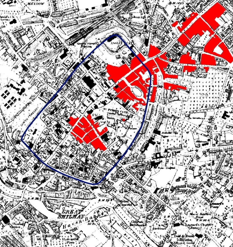
The map illustrates the immediate damage from the aftermath of the Baedeker Raid of 4 May 1942 transposed onto a map of 1890. These are the areas that were severely or partially damaged by high explosive bombs, incendiaries and the resulting fires. The outline of the city wall is shown in blue. The city wall area contained the city's oldest buildings and its most important buildings. As can be seen, the damage was extensive and there's no doubt that the damage to Exeter's architectural heritage was immense, including such landmark buildings as Bampfylde House, Bedford Circus, the Chevalier Inn, the Hall of the Vicars Choral, St Lawrence's church and St Catherine's Almshouses. Half of the High Street was severely damaged along with significant portions of the medieval suburb of St Sidwell to the north-east and, in the centre of the city, the area at the top of Fore Street and parts of South Street.
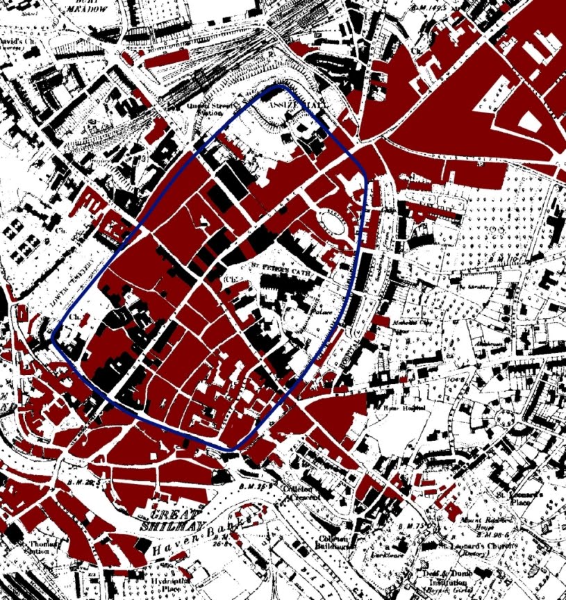
The image right is the same 1890 map. Incredibly, the areas coloured in red show property that appears on the 1890 map but which has been destroyed over the course of the 20th century. Everything in red are entire blocks of buildings that have either been destroyed in war or bulldozed by the city authorities themselves...
... Not just streets but entire districts have been flattened and rebuilt. Like a snake with its own tail in its mouth, the city has consumed itself almost totally, and it is no exaggeration to say that almost nothing remains. Half of Paul Street was demolished early in the 20th century, along with half of Catherine Street. The West Quarter, including Preston Street, Smythen Street, Coombe Street and Stepcote Hill, and which contained most of the city's surviving medieval and Tudor townhouses, was razed during the 1930s. The air-raid of 1942 accounted for half of South Street and the High Street as well as half of Southernhay, Paris Street and Sidwell Street and numerous small streets and alleys. The 1950s saw the demolition of most standing buildings in the war-damaged area as well as the remains of those which could've been salvaged. Exe Island and the Edwardian Exe Bridge were bulldozed in the 1950s and 1960s along with much of Cowick Street, Alphington Street, Mary Arches Street, Magdalen Street and a whole complex of 17th and 18th century buildings at Southgate for the construction of the Western Way inner bypass. The eastern side of North Street, the remaining half of Paul Street, and nearly all of Goldsmith Street and Waterbeer Street came down in the 1970s to build the Guildhall Shopping Centre. Many roads have simply ceased to exist, like Bampfylde Street, George Street, Musgrave Alley, St Stephen Street, Sun Street, etc. etc. It terms of Exeter's historical architecture, it has been nothing but a disaster.
The Destruction of Exeter in the 20th Century
This shouldn't understate the damage done by WW2, however:
"Exeter is the Jewel of the West, and We Have Destroyed It"
So boasted German radio the day after the city was attacked by bombers in the early hours of 4 May 1942. In many ways the statement was entirely accurate as, despite the demolition of so much in the 1930s, the attack of 1942 initiated a process of destruction that wasn't halted until the late 1970s, a period during which Exeter lost vast amounts of its historic architecture. The image left © Express & Echo, shows ruins in Catherine Street...

The architectural casualties included the Lower Market, Bedford Circus, Southernhay West, Dix's Field, Paragon House, the Hall of the Vicars Choral, St Catherine's Almshouses, the Country House Inn, the New Inn, the medieval church of St Lawrence, the Eastgate Arcade, Bampfylde House, the Abbots' Lodge, the Choristers' School, the Regency Subscription Rooms, Higher Summerlands, Deller's Cafe, the 'Norman House', the Chevalier Inn, the Globe Hotel, the former townhouse of the Earls of Morley, Nos. 226 & 227 on the High Street, the West of England Insurance building, and large areas of the West Quarter, Catherine Street, Sidwell Street, Paris Street, South Street and the High Street.
"Exeter is the Jewel of the West, and We Have Destroyed It"
Exeter Cathedral, properly known as the Cathedral Church of Saint Peter in Exeter, is an Anglican cathedral, and the seat of the Bishop of Exeter, in the city of Exeter, Devon, in South West England. The present building was complete by about 1400, and has several notable features, including an early set of misericords, an astronomical clock and the longest uninterrupted vaulted ceiling in England.
Exeter Cathedral - Wikipedia

The misericords definitely deserve some more attention:
Why the hubbub? I would think moving houses by the 1960s would be easy, considering we could raise whole cities a century earlier. But I know where that kind of thinking gets me!
Exeter - Wikipedia
Pshaw, physical evidence doesn't really matter when anything you date is basically "educated" speculation anyway.Exeter began as settlements on a dry ridge ending in a spur overlooking a navigable river teeming with fish, with fertile land nearby. Although there have been no major prehistoric finds, these advantages suggest the site was occupied early. Coins have been discovered from the Hellenistic kingdoms, suggesting the existence of a settlement trading with the Mediterranean as early as 250 bc. Such early towns had been a feature of pre-Roman Gaul as described by Julius Caesar in his Commentaries and it is possible that they existed in Britannia as well.
This site attributes most of the settlement to the Romans:
A History of ExeterExeter began as a Roman town. The Romans arrived in the Southwest about 50 AD they built a wooden fort on a hill near the river Exe at the lowest point where it could be easily crossed. (Exe is derived from a Celtic word meaning 'the water'). However, the local Celtic tribe put up little resistance to Roman rule and about 75 AD the soldiers moved on. A town was then created on the site of the fort. The Romans called it Isca.
Like all Roman towns Exeter or Isca had a rectangular space called the forum. This was the market place. It was also lined with shops and the basilica, a kind of town hall. There were also public baths in Roman Exeter. In Roman times people went to the baths not just to get clean but also to socialize. It was the Roman equivalent of going down the pub.
The Romans made Exeter the administrative center of Southwest England. However Roman civilization was skin deep in this part of the country. Further west it faded away altogether. In Roman Exeter, rich people lived in houses of stone with mosaic floors and even a form of central heating but poor people lived in simple wooden huts. Roman Exeter does not seem to have been a particularly prosperous town.
In the 2nd century the Romans built a sturdy wall around Exeter, which lasted for centuries. However, in the 4th century Roman civilization began to decline. The populations of the towns fell. The last Roman soldiers left Britain in 407 AD and the Roman way of life slowly disappeared. People drifted away from the towns to the countryside and returned to a simpler way of life.
The wall made it though. Behold, a nearly 2,000 year old wall!
It's a good thing we "know" how old things are because from just looking at this, I would have no idea. Also, this must be one of those self-maintaining walls, that held up for centuries after people "returned to a simple life."It has withstood sieges and assaults, bombings and demolition, and you can easily miss it, but buried behind Exeter's 20th century redevelopment is one of the most complete, well-preserved circuits of defensive city wall in England. About 72% of the circuit survives and both its layout and much of its fabric is nearly two thousand years old.
Unfortunately, a lot of the other historic remnants of this ageless city have not fared so well... and wouldn't you know it, it's the relatively recent past to blame! From the blog Demolition Exeter:
The reason I started this blog was because of an argument I had recently with someone who claimed that Exeter was a lovely city with 'lots of historic buildings'. I was surprised as I didn't see how anyone could think that Exeter had 'lots of historic buildings' when so many of them have been destroyed within the last century.
It's true that the ancient heart of Exeter has a number of exceptionally fine and historically important buildings, and you can almost count them on the fingers of two hands: the Cathedral, the Castle at Rougemont, the Guildhall, a number of medieval properties in the Cathedral Close, three superb terraces of Georgian townhouses, St Nicholas's Priory, about a dozen surviving timber-frame merchant houses, a few interesting 15th century parish churches and one street of good Victorian public buildings, including the remains of the Higher Market and the neo-Gothic museum. Around 70% of the City Wall also survives, although this is largely overlooked...
...Another widely-believed fallacy is that Exeter was destroyed during World War Two. It was not. It has been said to me more than once, and by more than one person, that the city council merely finished what the Germans started. But even this is untrue in some aspects, as the damage inflicted on the city in 1942 didn't even set a precedent. The city authorities had been pulling vast areas of the city down from the end of the 19th century onwards.
... Not just streets but entire districts have been flattened and rebuilt. Like a snake with its own tail in its mouth, the city has consumed itself almost totally, and it is no exaggeration to say that almost nothing remains. Half of Paul Street was demolished early in the 20th century, along with half of Catherine Street. The West Quarter, including Preston Street, Smythen Street, Coombe Street and Stepcote Hill, and which contained most of the city's surviving medieval and Tudor townhouses, was razed during the 1930s. The air-raid of 1942 accounted for half of South Street and the High Street as well as half of Southernhay, Paris Street and Sidwell Street and numerous small streets and alleys. The 1950s saw the demolition of most standing buildings in the war-damaged area as well as the remains of those which could've been salvaged. Exe Island and the Edwardian Exe Bridge were bulldozed in the 1950s and 1960s along with much of Cowick Street, Alphington Street, Mary Arches Street, Magdalen Street and a whole complex of 17th and 18th century buildings at Southgate for the construction of the Western Way inner bypass. The eastern side of North Street, the remaining half of Paul Street, and nearly all of Goldsmith Street and Waterbeer Street came down in the 1970s to build the Guildhall Shopping Centre. Many roads have simply ceased to exist, like Bampfylde Street, George Street, Musgrave Alley, St Stephen Street, Sun Street, etc. etc. It terms of Exeter's historical architecture, it has been nothing but a disaster.
The Destruction of Exeter in the 20th Century
This shouldn't understate the damage done by WW2, however:

So boasted German radio the day after the city was attacked by bombers in the early hours of 4 May 1942. In many ways the statement was entirely accurate as, despite the demolition of so much in the 1930s, the attack of 1942 initiated a process of destruction that wasn't halted until the late 1970s, a period during which Exeter lost vast amounts of its historic architecture. The image left © Express & Echo, shows ruins in Catherine Street...
The architectural casualties included the Lower Market, Bedford Circus, Southernhay West, Dix's Field, Paragon House, the Hall of the Vicars Choral, St Catherine's Almshouses, the Country House Inn, the New Inn, the medieval church of St Lawrence, the Eastgate Arcade, Bampfylde House, the Abbots' Lodge, the Choristers' School, the Regency Subscription Rooms, Higher Summerlands, Deller's Cafe, the 'Norman House', the Chevalier Inn, the Globe Hotel, the former townhouse of the Earls of Morley, Nos. 226 & 227 on the High Street, the West of England Insurance building, and large areas of the West Quarter, Catherine Street, Sidwell Street, Paris Street, South Street and the High Street.
"Exeter is the Jewel of the West, and We Have Destroyed It"
The Cathedral
Exeter Cathedral, properly known as the Cathedral Church of Saint Peter in Exeter, is an Anglican cathedral, and the seat of the Bishop of Exeter, in the city of Exeter, Devon, in South West England. The present building was complete by about 1400, and has several notable features, including an early set of misericords, an astronomical clock and the longest uninterrupted vaulted ceiling in England.
Exeter Cathedral - Wikipedia
The misericords definitely deserve some more attention:
WikiAmongst other things, they depict the earliest known wooden representation of an elephant in the UK.
So, out of 50, only TWO contain Biblical imagery, and at least one of those was carved AFTER the rest. Hmm...The tip-up seats in the back row of the choir stalls (occupied in medieval times by the dean and other officers, the vicars and the canons) were called misericordiæ because they "compassionately" alleviated the strain of unsupported standing through long services....
...The misericords of Exeter cathedral are the oldest existing set in England, started as early as 1230 and finished before 1279. (There is no record of them in the Fabric Accounts.) ...
The carvings under the seats have many themes. Many depict ‘stiff-leaved' foliage or grotesque creatures bursting into leaf. Some show inventions of the medieval bestiary or mythological creatures (centaurs, mermaids, a cockatrice and asp, wyverns and bird figures); others depict living creatures such as lions, leopards, fish and birds, others legends; human forms are found in all sorts of poses and there are two which directly refer to Biblical characters. Of the total of 50 misericords, 48 were carved in the 13th century one in the early 14th and one far cruder carving (depicting Herod), in the 15th century.


The House that Moved, ExeterTo move the entire house was a major project. The building was stripped to its frame, windows removed, then protected by a timber casing. The entire building was jacked up and set on metal wheels. To avoid damage to the historic timbers no iron screws or bolts were used. A framework of timbers was installed to strengthen the building against sideways slippage during the move. The house itself weighed 21 tons and the timber frame another 10 tons.
Starting on 9 December 1961 the building was moved on rails to its new home, a process that took 6 days and was watched by newsreel cameras and a horde of newspaper reporters.
Why the hubbub? I would think moving houses by the 1960s would be easy, considering we could raise whole cities a century earlier. But I know where that kind of thinking gets me!
Note: This OP was recovered from the Sh.org archive.
Note: Archived Sh.org replies to this OP are included in this thread.


