Quinsay was in Russia? TPTB says it was in China.

KD Archive

Not actually KorbenDallas
Active Member
Joined
Sep 22, 2020
Messages
4,691
Reaction score
1,500
If anything, this thread is an additional tribute to how messed up our history is, as far as locations and times go. As a food for thought, think about why the maps attributed to the 16th, 17th and 18th centuries used to display Scythia. Scythia kicked the bucket around 100 BC. Naturally, why 1,800 years later we can still see it mentioned the maps? Our contemporary cartographers do not mix in some ancient Roman Empire, or ancient Greece into our contemporary maps. These are just a few, but we have quite a lot out there.
Could Scythia be much closer on the time table than we are lead to believe? The reason I mentioned Scythia in this manner is due to me questioning the timing of the existence of Marco Polo, and Niccolo de Conti. Allegedly they lived in the 13th-15th centuries. I think the timing should be closer to the 1600s. That is if they even existed, for we have Jesuits in the mix, and this fact is a wild card of sorts. Anyways, Marco Polo and Niccolo de Conti are the primary sources for the information related to the city of Quinsay. There are other ones out there, but these two guys are special.

The City of Quinsay
12,000 bridges & 100 miles across
daniel_keller_asiae_nova_descriptio_antwerpen_1590.jpg

I will post a few cut outs from various books, but, in reality, you have to do some research/reading of your own. This topic has people like Columbus and Toscanelli in the mix. In general, the info is out there, and for those interested there will be a way to find some. Marco Polo was accused of exaggerating the observed in the city of Quinsay. 1,200 Quinsay bridges were reduced to 10, and some other things... what else is new? Here is an example of poor Polo being ridiculed. And this here is an example of TPTB moving the city of Quinsay to China.

About 45 degrees North
quinsay_23.jpg
Source

Quinsay_13.jpg
Source

Quinsay_11.jpg
Source

quinsay_12.jpg
Source

For those interested in the Columbus connection, please consider visiting the source of the cutout below.

Quinsay_14.jpg
Source

With Quinsay being arguably one of the greatest city this world has ever known, it is not surprising that the Powers That Be want us to know nothing about it. I should probably make two corrections here. Of course, it is not this world, but the previous one, and it was not in Russia but rather in the area currently occupied by Russia. We could say that the city of Quinsay was located in the eastern Tartaria. Yet, I'm inclined to think that these legs grow from Scythia, which allegedly predated Tartaria. Here are a few links to the images attributed to Quinsay:
  • QVINZAY: highly zoomable + backside
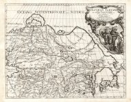
    • An aerial view of the city of Hangzhou, showing its buildings, canals and bridges, and junks in the surrounding water. This unusual plan perpetuates the description of Hangzhou given by Marco Polo in the late 12th century: its 12000 bridges, its massive network of canals, its paved roads and its large lake with island pavilions and palaces upon it. Jansson reproduced this information with fanciful embellishment. This is the only plan of China and the Far East to appear in Jansson's "Theatrum Urbium Celebriorum" (Amsterdam, 1657).
  • La cosmographie universelle d'André Thevet. Vol. 1
  • Daniel Keller. Asiae nova descriptio.
quinsay_12.jpg
quinsay_567.jpg

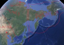
Judging by where the Wiki supported narrative wants to redirect us, we are required to think that Quinsay was in the area currently occupied by the Chinese city of Hangzhou.

Hangzhou North-South Coordinates:
  • 30°15′N
Hangzhou.jpg

I think that the city of Quinsay North-South coordinates were indeed:
  • ~44 to 45°N
These 15° degrees would mean an approximate difference of 1,000 miles, if we go straight up North from Hangzhou. This distance escalates to approximately 1,250 miles, when we account for the outline of the continent of Asia. Of course, this location would also mean that Marco Polo traveled to some places the knowledge of which TPTB chose to keep to themselves.

Polo had never visited Russia, right?
Map-1270s-MarcoPolo.jpg

Quinsay on the Maps
With the Straight of Anian, aka Bering Straight to the right, and Japan just below, it is hard to imagine how TPTB managed to move the city of Quinsay all the way to 30° N.
You are welcome to play with this progression yourself. In the process you will see the floating island of Korea approaching its place of rest where it eventually turns into a peninsular.

Prester John
Somehow, we have Prester John in the mix here. Go figure why 17th century maps would have this important historical figure mentioned at all. I've seen quite a few of them maps mentioning the guy.


Interesting enough, but one of the allegedly earliest depictions of the Three Wisemen, or Three Magi (with one claimed to be Prester John) has all three wearing Scythian Hats. Those little coincidences...

kd_separator.jpg
KD: This info is just for an FYI. Do with this what you will. Whether Marco Polo went there or not appears to be fairly obvious. The narrative says otherwise. So many cities can be observed in that area. Whatever happened...
Note: This OP was recovered from the Sh.org archive.
Note: Archived Sh.org replies to this OP are included in this thread.
 
Note: This post was recovered from the Sh.org archive.
Username: dreamtime
Date: 2019-12-08 11:53:02
Reaction Score: 1
I came to the same conclusion some time ago when I tried to locate the mysterious city on the maps.

Quinsay was in the north east, and i think the area where it was is submerged into the sea nowadays, that’s how it looked to me at least.

Marco Polo indicates that it was the most glorious city in the world, so I was fascinated by its description.

The Hanghzou connection doesn’t make any sense.
 
Note: This post was recovered from the Sh.org archive.
Username: KorbenDallas
Date: 2019-12-08 22:18:22
Reaction Score: 1
It sounds like it was one amazing city. I wish we had more images of the place. Whatever happened to it...
 
Note: This post was recovered from the Sh.org archive.
Username: mythstifieD
Date: 2019-12-12 03:01:35
Reaction Score: 3
*a wild mythstified appears!*

Fomenko dedicates an entire volume to Marco Polo and how he never went all the way to Asia. In fact he makes a compelling case that he went to visit the Khans and Tsars of Tartaria in what's now Russia.

Most intriguingly he explains the vast tents of the Mongols is a mistranslation and indeed they were actually describing magnificent stone castles.
I'm struck by these water cities. Venice, Mexico City, and now Quincy? So strange.
Is there anything to perhaps show Quincy moreso in Russia?
 
Note: This post was recovered from the Sh.org archive.
Username: dreamtime
Date: 2019-12-12 08:34:39
Reaction Score: 3
The question with Polo for me is mostly the time frame in question. When you think about it, its one of the oldest coherent sources in human history - 13th Century. That rings alarm bells for me.

I read the book and the way it is written sounds more like 17th or 18th century to me.

The history of how his writings showed up, and the uncertainty around the existence of the author itself, makes me think someone republished a censored version of some kind of mundane travel report around 150-200 years ago.
 
Note: This post was recovered from the Sh.org archive.
Username: mythstifieD
Date: 2019-12-14 17:12:33
Reaction Score: 2
This manuscript from about 1350 is one of the oldest extant copies of Les voyages de Marco Polo (The travels of Marco Polo), the account by the Venetian merchant Marco Polo (circa 1254−1324) of his adventures in Central Asia and the Far East during the latter part of the 13th century. It is possibly one of five manuscripts relating to Marco Polo’s journey that belonged to King Charles V of France (reigned 1364−80). Later it was part of the library of the French book collector Alexandre Petau. It was sold to Queen Christina of Sweden (1626−89) in 1650.

The Travels of Marco Polo

1650? Sounds more like it. Isn't this always the case?

BTW did you check out the document I linked to? If you've actually read Marco Polo you'll find it very interesting!
 
I have been studying this area and I think I have enough data about it.

I will focus on the mythical kingdom called Serica which seems to be related to the Tocario people, Caucasian people.

  • First of all, Pliny the Elder tells of the expedition of Annius Plocamo to Taprobane (perhaps Ceylon, Indonesia or even Tacloban in the Philippines). He tells that the father of a certain Raquias, an ambassador of Taprobane, had visited the country of the beings:

(...) Beyond the Emodio Mountains, there was the people of the beings, who were known for trade. The father of Rachias had come there and upon his arrival the beings had come to meet him. They were tall, blond-haired, blue-eyed individuals, they had a raucous voice and their language was not very suitable for trade.
Serica - Wikipedia

FRA MAURO SERICA2.png

It should not be forgotten that beyond the Emodios Mountains (i.e. the Himalayas), in the region of western China known as Uighur, there were two Indo-European peoples, the Tocharians and the Indo-Iranian Sakas and Sogdians.

The identification of the beings with an Indo-European people and not with the Han Chinese seems necessary considering the fact that many mummified bodies with North European characteristics (Tarim mummies) have been found in Uyghur. In the rest of the region, according to Chinese chronicles, lived peoples such as the Wusun, whose description coincides with that of Pliny.

It seems therefore clear that in the Roman Empire, the name of beings was not known to the Chinese themselves, but to Indo-Europeans who still survived in the city-states that were the passage of the caravans from the oases of the Taklamakan desert on the Silk Road.


3 - copia.png

Between the 4th millennium B.C. and the beginning of the 2nd millennium B.C. there was a Caucasian-looking population in this extensive territory, many of whose individuals had blond or red hair and light eyes.
On the other hand, Chinese history begins to be such from Sima Qian, so that before that historian, just as Chinese written history does not exist as such, even less can there be from Chinese sources a history of the tokars.
The Silk Road ran along the Tarim Basin to the ancient Chinese western boundary at the Lulan Gates. The oases in which the Tocaryans lived were milestones or obligatory stages of this route, so that the Tocaryan peoples, while cultivating their fertile lands, benefited from the trade that developed along it.
In the year 400 A.D., a Chinese traveler, Zhimeng, relates that in "the city of Kucha there are high towers and palaces of several floors decorated with gold and silver". The Chinese were enraptured by the magnificent royal palace of such a city, where the halls were richly decorated with gold, jade and langgan. The langgan would be a red variety of jade that the populations of the Tarim Basin sold to China.

The fodder tokens have been thrown far back in time, millennia before Christ. This is how their encounter with the Greeks in Bactria happened.

1280px-Asia_001ad.jpg

Around 176 B.C. Mongol peoples attacked the kingdoms of the Tarim Basin, refugees from these kingdoms marched en masse towards Bactria and the present territories of Kyrgyzstan, and Afghanistan, it is for this reason that in the 2nd century B.C. the Greeks found them and gave them the name τóχαροι (tokharoi), hence the Latin tocharii (singular tocharius). Some testimonies of such a Greek appellation are documented by Strabo (11.8.2) and later by Ptolemy (6.11.6); the latter called them tagouraioi). Now, Thagurus was the name given in antiquity by the Latins to Serindia (i.e. the main territory traversed by the Silk Road). This same territory was called Tukaras or Tusharas (in Sanskrit) and Tu-hu-lo (in Chinese). The settlement of these people in Bactria caused this territory to be called Tojaristan by the Persians, and also as it was known as Tokaristan or Tokaria throughout the first millennium of the Christian era.
Tocharians - Wikipedia

  • REMARK: The Greeks found them and gave them the name τóχαροι (tokharoi), hence the Latin tocharii (singular tocharius). Now, Thagurus was the name given in antiquity by the Latins to Serindia (i.e. the main territory traversed by the Silk Road). This same territory was called Tukaras or Tusharas (in Sanskrit) and Tu-hu-lo (in Chinese).
  • The kingdom of Serica has just been linked to the Tocaries.
  • According to some researchers, the Tocharians or part of them called themselves arcia and seras, for this reason it is said that their ancestral territory was called Serica, and then, by metonymy, this name was applied by the Europeans to China with the meaning of 'country of silk'.

But let's see one more map: Fra Mauro 1450, if we focus on all the sites, as well as the river with the name of serica, sea of sericus, where even the mythical Quinsay that Marcopolo talked about is its course.

2.png
Composite map: Mappemonde Pl. 1-6

3.png

4.png
Abbozzo Del Mappamondo Di F: Mauro Camaldolese

In the map of Urbano Monte 1587, we see that the region where Serica was is now the province of Mangi.
Mangi reminds me of one of Genjiskan's grandsons:

Temüdyin's wife, Bourtai, had a name meaning "gray eyes". Temüdyin's relatives and descendants had distinct features: Temüdyin's son and successor, Ogadei (1229-41), had gray eyes and red hair; Temüdyin's grandson, Mangu who is the one I am referring to (1251-9) had reddish eyebrows and a reddish-brown beard; the one who followed him Subatei, conquered China, had a long beard and red hair. In fact, it is said that people were surprised that Kubilai Khan had dark hair and eyes, as most of Genghis Khan's descendants had reddish hair and blue eyes.

When Marco Polo arrived with Kublai Khan, the part of Serica and China already belonged to the Mongols, funny that Urbano Monte puts the Chinese walls and Marcopolo does not mention them, Fra mauro puts Alexander the Great in the Caucasus and talks about the walls to enclose Gog and Magog.

1587 urbano monte2.png
Composite: Tavola 1-60. (Map of the World) (with additional spheres and labels in the four corners).

If I use the KD maps we get similar views, only that some of these maps do name Serica right in the Mangi area.

1560 SERICA.png

1570 SERICA.png

  • About Prester John I want to add that Marcopolo tells us about his fall at the hands of Genghis Khan when he gathers all the Tatar tribes, wiki speaks of a Prester John reigning over Kara Kitay (perhaps Cataio as it appears on the maps) although the Portuguese later claimed to have found him in Ethiopia.
Prester John - Wikipedia
One of the KD maps says that the apostle Thomas founded the city of Argon next to Arsaret. That Prester John is its custodian.
This city Argon also appears written as Aragon in other maps, like the one of Urbano Monte.

1587 urbano monte3.png

  • It is precisely in Aragon in Spain that a marriage union is formed with Ethiophia, where we are shown the coat of arms of Preste Juan (ruler of the three Indies). For more information, see my threads on the subject.

"Tartaria" is a myth and didn't exist
Is Mexico-Tenochtitlan in reality the mythic Quinsay as described by Marco Polo?
The secret of the twins Quetzalcoatl and Xolotl

  • These data seem to me to be important for the subject as well:

Quetzalcoatl was a white, blue-eyed individual. The friars of the XVI century tried to find the reason for the presence of the indigenous people in these lands by looking for the answer in the Bible, concluding that they were part of the dispersed tribes of Israel.
On the other hand, the image of Quetzalcoatl, a character who did not accept human sacrifices and who was chaste, came to hand so that the friars began to consider that he was some kind of apostle. Fray Diego Durán says: "That venerable man, whom they call Topiltzin [...] was according to indigenous traditions a chaste and penitent priest, of whom apparently miraculous episodes are remembered [...] this holy man was some apostle that God brought to this land".
Don Carlos de Sigüenza y Góngora wrote in the second half of the 17th century (Sigüenza y Góngora, 1959) that Quetzalcóatl was the apostle Saint Thomas, who had come to preach the Gospel"...that Saint Thomas, one of the Twelve Apostles, had migrated to this land, whom they called Quetzalcóatl, finding the coincidence of both names by the Apostle's clothing, doctrine and prophecies..."
1794, Fray Servando Teresa de Mier was invited to give the sermon in honor of the Virgin of Guadalupe. Based on data from José Ignacio Borunda, who had written his Clave general de interpretación de los jeroglíficos mexicanos, in which he established that the tilma of Juan Diego where the Guadalupana was represented was none other than the garment of Santo Tomás/Quetzalcóatl, he lashed out against the Spaniards denying that they were the first to evangelize in New Spain, since that had been done centuries before by the apostle in the figure of Quetzalcóatl. Quetzalcoatl


3.png

  • Even this could give us an idea of why in Asia and America the snake (Dragon) seems to be very important, if you read this thread about the Cathars and the reason for their persecution, for them the snake did not have an evil notion.
Is Mexico-Tenochtitlan in reality the mythic Quinsay as described by Marco Polo?

Considering that Prester John ruled in Kara Kitay or Cataio as in the maps, would they be Cathars?

  • Ah! by the way.... Great Kan would be a great serpent if we consider that...

Precisely the twin brother of the serpent Quetzalcoatl was Xolotl, the dog-god of the underworld. And it is curious because Marco Polo named the Tartar King of Kings, either "Great Can", in Latin "Great Dog" as Xolotl; or Great Kaaan, in Mayan "Great Serpent" as Quetzalcoalt.

YaxchilanDivineSerpent.jpg
Yaxchilan Divine Serpent Maya

 
Last edited:
If I'm reading everything correctly, and I may not be, but after comparing landmarks on Urbano Monte, Ortelius' maps of Tartary, and Cantelli da Vignola, on Urbano Monte the Great Wall of China seems to be present, which ends a bit north of Beijing. Tazata Island of Scythian Myth may be Wrangel Island or the Anzhu Isles, while Bargu/Bargo may be the bit of land jutting out nearby, but for these maps to be correct unless our current "satellite" maps are entirely fake and distorted....
Pretty much the entire northeast chunk of Siberia would've have to have been America

Karacatay is present on the Cantelli map as well. Maybe I'm a moron but it's hard to ignore how you'd have to have significant continental creep of America into Siberia for Japan to be sandwiched like that. But all other landmarks like Nova Zemla and Japan are consistent. Even Greenland and Nova Zemla on Urbano Monte, the only thing different is the Anian Strait can't possibly be the Bering Strait because the Bering Strait is way further east.

The other explanation is that there's not a massive swathe of ocean between the two continents like on the globe model.
 

Attachments

  • america.jpg
    america.jpg
    407.6 KB · Views: 74
  • Tartaria-cantellirossi-1693.jpg
    Tartaria-cantellirossi-1693.jpg
    716.8 KB · Views: 111
Tips
Tips
Please respect our Posting Rules.
Back
Top